Contents
- Setup and Infrastructure
- Processing Speed and Quality
- Device Compatibility
- Accuracy and Measurement
- Support and Reliability
- Compliance and Security
- True Cost of Ownership
- The Bottom Line
- Related Comparisons
- Get a SkyeBrowse Recommendation
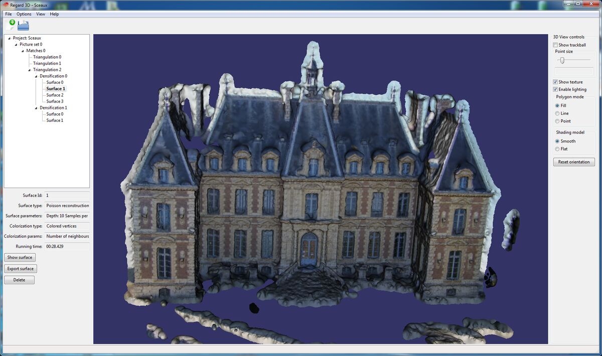
Regard3D is a free, MIT-licensed desktop photogrammetry application maintained by a single developer that converts photographs into basic 3D meshes using CPU-only processing. SkyeBrowse is a managed cloud platform that converts video from any camera into production-grade, measurable 3D models using patented videogrammetry. The gap between these two tools is the widest in the open-source category.
Setup and Infrastructure
Regard3D is easy to install. Download the application, run the installer, and the wizard-based interface is ready on Windows, macOS, or Linux. That simplicity is its strongest feature. No Docker, no command line, no dependencies. The footprint is small (a few hundred megabytes), and it runs on consumer-grade hardware without a dedicated GPU. The tradeoff is that everything runs on your local CPU, which means processing is slow, and the software struggles with datasets beyond a few dozen photographs.
SkyeBrowse runs entirely in the cloud. No local installation, no hardware dependency, no storage management. A user on any device with a web browser uploads video and receives a finished model processed on AWS GovCloud infrastructure. While Regard3D's lightweight install is appealing for a first experiment, SkyeBrowse's cloud architecture means zero infrastructure decisions, zero maintenance, and zero performance ceiling tied to local hardware. The platform handles one model or a thousand without any change to the user's setup.
Processing Speed and Quality
Regard3D's CPU-only pipeline is slow by any standard. A set of 50-80 photographs takes 15-30 minutes on consumer hardware. Larger datasets take considerably longer, and the software frequently struggles or crashes beyond a few hundred images. Output quality is acceptable for small-scale visualization, but it falls a step below other open-source tools like Meshroom or ODM for complex scenes. Reflective surfaces, large-scale environments, and intricate geometry consistently challenge the algorithms.
SkyeBrowse processes video at a roughly 1:1 ratio: ten minutes of video produces a finished model in about ten minutes, regardless of scene complexity. Premium Advanced delivers 16K resolution with AI-powered moving object removal. Premium delivers 8K resolution. Lite produces rapid reference models. Where Regard3D slows to a crawl on a 100-photo dataset, SkyeBrowse processes a 30-minute capture in 30 minutes with consistent, production-grade output. The quality gap is not incremental; it is generational.
Device Compatibility
Regard3D accepts photographs only. No video, no body-worn camera footage, no 360-degree captures. Every input must be a set of individual photos loaded from the local filesystem. The software was designed for DSLR and compact camera photos of objects and small scenes. Large-scale site documentation and multi-device workflows are outside its design scope entirely.
SkyeBrowse accepts any .MP4 or .MOV video through Universal Upload. Drones, smartphones, body-worn cameras, GoPros, and 360-degree cameras all feed the same pipeline. An agency can document a crash scene with a drone, capture a building interior with a phone, and record a tactical pre-plan with a 360 camera, all processed through one platform. Regard3D limits you to one input type from one camera at a time. SkyeBrowse accepts anything that records video from any source.

Accuracy and Measurement
Regard3D produces 3D meshes and point clouds with no measurement capability and no georeferencing. The output is a visual representation of a scene with no spatial calibration. You cannot extract distances, areas, or volumes. You cannot place the model on a map. You cannot export coordinates. For any workflow requiring defensible dimensions (court evidence, engineering analysis, insurance documentation, construction monitoring), Regard3D's output is unusable.
SkyeBrowse is purpose-built for measurement. Premium Advanced delivers 0.1-inch accuracy at 16K resolution with calibrated tools built into the platform. Premium provides 0.25-inch accuracy at 8K resolution. Even Lite, at 2-6 inch accuracy, delivers more spatial utility than Regard3D can provide at any setting. Exports include LAZ point clouds for forensic reconstruction and CAD integration, GLB meshes for interactive courtroom walkthroughs, and GeoTIFF orthomosaics for GIS analysis. The difference is categorical: Regard3D creates pictures of things. SkyeBrowse creates spatial data you can measure, analyze, and defend.
Support and Reliability
Regard3D is a single-developer project. Roman Hiestand maintains it when time allows, but releases are infrequent (separated by months or years), and there is no dedicated support channel. Documentation consists of a user manual and tutorials on the project website. The community is very small compared to ODM or Meshroom. When something breaks or produces unexpected results, you are essentially on your own.
SkyeBrowse provides commercial support with defined response times, structured onboarding tailored to your vertical, and a team that understands public safety, fire department, and construction workflows. When an agency needs help during an active incident, there is a team to call. The difference between a single hobbyist developer and a commercial support operation is the difference between best-effort and guaranteed.
Compliance and Security
Regard3D has no compliance certifications. Data stays on your local hard drive with whatever security your operating system provides. There is no audit trail, no access control, no sharing mechanism, no data retention policy, and no chain-of-custody support. For any government, law enforcement, or regulated organization, Regard3D cannot be part of a compliant workflow without building an entire security framework around a desktop application that was never designed for it.
SkyeBrowse runs on AWS GovCloud (US) with FedRAMP Moderate authorization and CJIS-compliant workflows. Every action is logged in audit trails. Controlled sharing ensures evidence reaches only authorized parties. Role-based access controls govern who can view, edit, and export. Premium and Premium Advanced tiers include 5-year guaranteed data retention. Regard3D offers nothing in this dimension. SkyeBrowse treats compliance as a core platform feature.
True Cost of Ownership
Regard3D is free under the MIT license and runs on hardware most people already own. For a student learning photogrammetry basics or a hobbyist digitizing small objects, the cost of ownership is genuinely close to zero. That is a real advantage for casual, non-critical use.
The cost equation changes the moment you need operational output. No measurement tools means you need additional software to extract dimensions. No georeferencing means you need additional tools for spatial context. No compliance means you need IT infrastructure to secure and manage outputs. No support means your team absorbs troubleshooting time internally. No scalability means large projects require different software entirely. The "free" tool becomes a patchwork of workarounds that cost more in labor than a managed platform costs in subscription fees. SkyeBrowse's subscription includes processing, calibrated measurement, compliance, support, 5-year data retention, and continuous updates. When scene documentation drops from 3 hours with 4 officers ($360) to 10 minutes with 1 operator ($25), the business case is not close.
| Regard3D | SkyeBrowse | |
|---|---|---|
| Infrastructure | Local desktop application | Managed cloud (AWS GovCloud) |
| Input | Photographs only | Any .MP4/.MOV (drones, phones, BWC, 360) |
| Processing | CPU-only, slow, struggles beyond ~100 photos | ~1:1 ratio, scales to any capture length |
| Measurement Tools | None | Calibrated, built-in |
| Georeferencing | Not supported | Built-in, GeoTIFF export |
| Accuracy | No calibrated measurement | 0.1" (Advanced), 0.25" (Premium), 2-6" (Lite) |
| Exports | PLY, OBJ meshes | LAZ, GLB, GeoTIFF |
| Compliance | None | CJIS, FedRAMP Moderate |
| Support | Single developer, no SLA | Commercial SLA |
| Data Retention | Local only | 5-year guaranteed |
| Development Status | Infrequent updates, single maintainer | Continuous development, commercial team |
| True Cost | Free + labor for workarounds | Predictable subscription |
The Bottom Line
Regard3D is the simplest path to a first 3D model from photos. Install it, load some images, click through the wizard. For that narrow use case (learning, hobbyist experimentation, small object digitization), it works. For everything else, SkyeBrowse is in a different category entirely. It accepts video from any device, processes in minutes instead of tens of minutes, delivers calibrated measurements instead of visual-only output, runs on CJIS-compliant infrastructure with guaranteed retention, and provides commercial support instead of a single developer's availability. No operational team should evaluate Regard3D and SkyeBrowse as alternatives. They solve different problems at different scales for different users.
Get a SkyeBrowse Recommendation
If your 3D models need to withstand scrutiny in court, in a boardroom, or on a construction site, SkyeBrowse delivers the accuracy, compliance, and support that free tools cannot.