Digital twin technology — the practice of building a precise, navigable virtual replica of a physical object or location — has transformed how engineers, contractors, and public safety agencies document and analyze the built environment. By pairing consumer drones with cloud-based videogrammetry (the process of extracting 3D geometry from video footage), teams can now create digital twins of buildings, infrastructure, and job sites in minutes rather than months, without specialized surveying hardware.
Key Takeaways
- Digital twin technology for the built environment has shifted from expensive LiDAR and manual survey workflows to drone-captured 3D models that cost a fraction of traditional methods and deliver results the same day.
- Drone-based digital twins achieve sub-inch accuracy (as low as 0.1 inch with SkyeBrowse Premium Advanced processing), meeting documentation standards for engineering, legal discovery, and insurance claims.
- Construction teams use digital twin technology to track progress against design, catch clashes before they become rework, and produce as-built records without pulling survey crews off other tasks.
- Public safety agencies — police, fire, and search-and-rescue teams — use drone-generated digital twins for scene documentation, pre-incident planning, and post-incident review across more than 1,200 agencies worldwide.
- SkyeBrowse accepts standard drone video (.MP4, .MOV) and returns exportable 3D formats (GLB mesh, LAZ point cloud, GeoTIFF orthomosaic) within minutes of upload — no desktop processing hardware required.
Contents
- What is digital twin technology?
- How does drone-based digital twin technology work?
- What are the best digital twin technology examples in construction and infrastructure?
- How does digital twin technology serve public safety and inspection?
- What accuracy and outputs does drone digital twin technology produce?
- FAQ
What is digital twin technology?
Digital twin technology is a method of creating a precise virtual replica — a "twin" — of a physical asset, site, or system that can be analyzed, updated, and shared without revisiting the physical location. NIST defines a digital twin as a set of virtual information constructs that fully describe a physical manufactured product. For the built environment, this means a 3D model accurate enough to take measurements, identify defects, and make engineering decisions from a desktop or mobile device.
The concept originated in aerospace and manufacturing, where NASA used asset mirroring techniques to simulate spacecraft conditions during the Apollo program. Over the past decade, the combination of affordable drones, photogrammetry software, and cloud computing has made the technology accessible to construction, infrastructure, and public safety teams without requiring million-dollar LiDAR systems or weeks of field survey work.
A built-environment digital twin typically consists of a georeferenced 3D mesh (or point cloud), an orthomosaic (a geometrically corrected 2D aerial map), and associated metadata such as timestamps and GPS coordinates. These outputs feed directly into BIM (Building Information Modeling) workflows, GIS platforms, and project management tools. For a deeper look at what a digital twin actually contains, see what is a digital twin.
How does drone-based digital twin technology work?
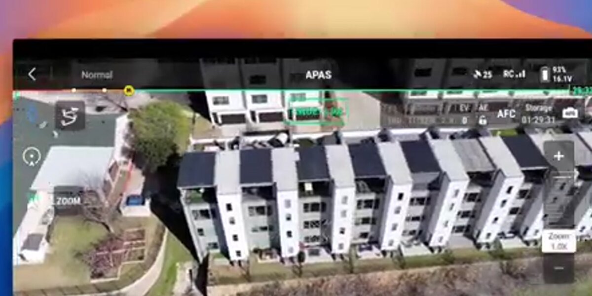
Drone-based digital twin technology uses photogrammetry or videogrammetry to reconstruct 3D geometry from overlapping images or video frames. A drone orbits or flies a grid pattern over the target site, capturing footage from multiple angles. The software then identifies common features across frames, calculates the relative position and orientation of each frame, and triangulates a dense point cloud that becomes the digital twin. The entire capture-to-model pipeline takes under two hours for most sites.
Traditional photogrammetry workflows require pilots to plan precise grid missions, capture thousands of individual still images, and process them on high-powered desktop workstations — often overnight. Videogrammetry, the approach used by SkyeBrowse, removes those constraints by processing standard video footage (.MP4 or .MOV) from any supported drone directly in the cloud. Pilots fly any flight pattern, upload footage to app.skyebrowse.com, and receive a navigable 3D model within minutes.
Telemetry files — .SRT from DJI drones, .ASS from Autel — improve georeferencing accuracy by embedding GPS and altitude data into the footage. For sites requiring survey-grade accuracy, teams add ground control points (GCPs) to anchor the model to known coordinates. The result is a digital twin that can be measured, annotated, and exported without any additional field time. For a full walkthrough of the process, see the drone digital twin guide.

What are the best digital twin technology examples in construction and infrastructure?
In construction, digital twin technology is used for progress monitoring, clash detection, as-built documentation, earthwork volume calculations, and handover records. A project team flies the site weekly, comparing the current 3D model against the design BIM to catch deviations before they require expensive rework. Infrastructure owners use digital twins to document bridge decks, retaining walls, and utility corridors for ongoing maintenance planning and regulatory reporting.
Digital twin technology in construction addresses one of the industry's most persistent problems: the gap between what was designed and what was built. Traditional as-built documentation relies on manual measurements taken by survey crews — a process that is slow, expensive, and prone to gaps. A drone-generated digital twin captures the entire site geometry in one flight, producing a permanent record that project managers, inspectors, and legal teams can access and interrogate for years.
Specific digital twin examples from the built environment include:
- Progress monitoring: Weekly drone flights compared against BIM design files to flag schedule deviations — see the construction progress monitoring guide for recurring-capture cadence.
- Earthwork and grading: Cut-and-fill volume calculations from orthomosaic layers, updated after each grading pass.
- Bridge and infrastructure inspection: Photogrammetric models of bridge decks, piers, and abutments that replace rope-access inspections for routine condition assessments.
- Utility corridor mapping: Linear infrastructure documented in a single corridor flight, georeferenced to GIS layers.
- Pre-purchase due diligence: 3D models of buildings and sites used by buyers, insurers, and lenders to assess condition before closing.
For detailed guidance on applying these workflows in construction, see digital twin technology in construction and digital twin building.
According to a McKinsey Global Institute report on construction productivity, the construction sector has historically been one of the least digitized industries, but digital twin adoption is now accelerating as drone capture costs fall below the rework costs they prevent. The American Institute of Architects' research shows that digital documentation reduces change orders by identifying design-reality conflicts early in the build cycle.
How does digital twin technology serve public safety and inspection?
Public safety agencies use drone-generated digital twins for three core missions: pre-incident planning (scanning buildings and venues before events), scene documentation (capturing crash scenes, crime scenes, and fire scenes as permanent 3D records), and post-incident analysis (reviewing 3D reconstructions for investigation and training). Digital twins created for safety purposes must meet evidentiary standards for chain of custody and accuracy, which is why platforms hosting sensitive scene data use FedRAMP-authorized cloud infrastructure with CJIS-focused access controls.
For law enforcement, a drone digital twin of a crash or crime scene can be captured before the roadway is reopened or the scene is cleared, preserving geometry and spatial relationships that would otherwise be lost. The 3D model can be shared with prosecutors, defense teams, and accident reconstruction experts without requiring physical site revisits. SkyeBrowse serves more than 1,200 agencies worldwide and is hosted on AWS GovCloud with FedRAMP Moderate Authorization, meeting the infrastructure requirements for law enforcement data handling.
For fire departments, pre-incident digital twins of commercial buildings, warehouses, and large venues give commanders a navigable 3D model to study during planning — identifying entry points, stairwells, and hazardous storage areas before a fire event. Post-incident, the same workflow documents fire spread patterns and structural damage for insurance adjusters, fire marshals, and litigation support.
Infrastructure inspection agencies use digital twins to replace or supplement rope-access and bucket-truck inspections. A single drone flight over a bridge or cell tower produces a 3D model with sufficient resolution for defect identification, cost estimation, and regulatory reporting — without closing lanes or putting inspectors at height. For teams focused on bridge and roadway inspections, drone-generated twins reduce the need for lane closures and rope-access crews. IEEE and NIST have both published frameworks for using digital twins in infrastructure asset management, citing reduced inspection costs and improved maintenance scheduling as primary benefits.
What accuracy and outputs does drone digital twin technology produce?
Drone digital twin technology produces three primary output types: a 3D mesh (GLB format, suitable for web viewers and BIM workflows), a point cloud (LAZ format, compatible with GIS and CAD tools), and an orthomosaic (GeoTIFF format, georeferenced 2D aerial map). Accuracy ranges from 2–6 inches for standard consumer drone captures to 0.1 inch for high-resolution 16K processing with AI moving-object removal — the latter suitable for legal, engineering, and insurance documentation.
Accuracy in drone-based digital twins depends on four variables: drone sensor resolution, flight altitude and overlap, presence of ground control points, and processing tier. Lower-altitude flights with higher frame overlap produce denser point clouds and sharper meshes. GCPs — surveyed markers placed on the ground before flight — anchor the model to real-world coordinates, eliminating the GPS drift that affects consumer drone telemetry.
SkyeBrowse offers three accuracy tiers directly accessible from app.skyebrowse.com:
| Tier | Resolution | Accuracy | Best For |
|---|---|---|---|
| Lite | Standard | 2–6 inches | Scene overview, progress tracking |
| Premium | 8K | 0.25 inch | Engineering review, insurance documentation |
| Premium Advanced | 16K + AI | 0.1 inch | Legal discovery, forensic reconstruction |
For teams evaluating digital twin software options across these accuracy tiers, see best digital twin software for a platform comparison. SkyeBrowse pricing starts at $99 per Premium model credit and $199 per Premium Advanced credit, available at skyebrowse.com/pricing-premium.
FAQ
What is digital twin technology?
Digital twin technology is the practice of creating a virtual replica of a physical asset or location — accurate enough to take measurements, run simulations, and make engineering or operational decisions remotely. For the built environment, drone-based photogrammetry and videogrammetry are the most practical capture methods, producing georeferenced 3D models from a single flight. Learn more at what is a digital twin.
What are real-world digital twin technology examples?
Common examples include construction progress monitoring (weekly drone flights compared against BIM design files), bridge and infrastructure inspection (photogrammetric models replacing rope-access surveys), crash and crime scene documentation (law enforcement 3D records for legal proceedings), and pre-incident building scans for fire department planning. Each of these applications uses the same core capture-and-process pipeline, differing mainly in accuracy tier and output format required.
How does digital twin technology in construction differ from BIM?
BIM (Building Information Modeling) is a design-side workflow: it models how a building should be built. Digital twin technology, in the construction context, captures how the building is actually being built — or how it exists post-construction. The two are complementary: drone-generated digital twins are compared against BIM design models to identify deviations, and as-built digital twins serve as the permanent record after a project closes. See digital twin technology in construction for a detailed breakdown of how these workflows integrate.