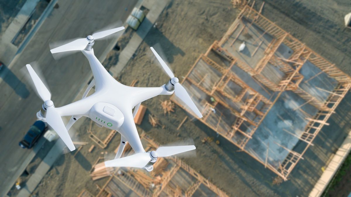
Drone surveying — also called aerial drone surveying — is now one of the fastest-growing methods for collecting topographic, planimetric, and site condition data across dozens of industries. A 3D drone survey captures millions of surface points from the air, producing the same deliverables as traditional ground methods in a fraction of the time. Where a ground crew once needed days to produce a site topo, a single operator with a UAV survey setup can cover the same area in hours and generate deliverables that plug directly into CAD and GIS workflows. But the technology is only as useful as the workflow behind it. This guide covers everything you need to know: how drone surveying works, what accuracy is realistic, what it costs, what equipment you need, and what the regulations require.

Contents
- Drone Surveying in 2026: Workflow Snapshot
- What Is Drone Surveying?
- What Is Aerial Drone Surveying?
- How Does a UAV Survey Work? The Full Workflow
- What Accuracy Can You Expect from Drone Land Surveying?
- What Does Drone Survey Cost?
- What Equipment Do You Need for Drone Surveying?
- What Are the Best Drones for Surveying and Mapping?
- What Are the Regulatory Requirements for UAV Surveys?
- Which Industries Use Drone Surveying?
- Drone Surveying Case Examples
- What Deliverables Does a Drone Survey Produce?
Drone Surveying in 2026: Workflow Snapshot
Drone surveying in 2026 follows a tighter, faster pipeline than even a few years ago — primarily because cloud processing and RTK hardware have converged into a near-seamless loop. Here is what a typical professional engagement looks like from wheels-up to deliverable hand-off.
Capture (30–90 minutes on site). A Part 107 pilot pre-programs a grid or corridor flight, places 5–8 RTK-verified GCPs, and executes the mission. A 50-acre site at 150 ft AGL with 80/70 overlap takes roughly 45 minutes of flight time. A 5-mile linear corridor — say, a utility right-of-way — runs 60–90 minutes split across two battery sets, with a fixed-wing or hybrid VTOL platform covering ground faster than a multi-rotor. The raw output is 800–2,000 frames (still-image capture) or 15–40 minutes of 4K video (video-based capture).
Cloud upload and processing (1–4 hours). Files go straight from the field to cloud infrastructure — no desktop transfer queue. Processing time scales with data volume: a typical 50-acre photogrammetry job returns initial results in 1.5–2 hours. Video-based platforms running on dedicated GPU infrastructure can process faster for comparable coverage. Point cloud density runs 50–200 points per square meter at standard altitude settings.
3D model QA (15–30 minutes). The operator checks model-to-GCP residuals, spot-checks elevation values against independent check shots, and flags any low-confidence areas (dense tree canopy, standing water, highly reflective surfaces) for field supplementation.
CAD/GIS export (10–20 minutes). Compliant outputs export as GeoTIFF orthomosaics (GIS), LAZ point clouds (Civil 3D, Trimble Business Center), DXF contour sets (engineering drawings), and GLB meshes (3D visualization or courtroom use). Most platforms support direct Esri or Autodesk integration.
Total elapsed time — concept to client deliverable: 4–8 hours for a standard construction or land development site. Compare that to a traditional ground survey of similar scope: 2–4 days of field work plus 1–2 days of office processing. The efficiency gap is largest on sites above 10 acres where ground crews would otherwise need to leapfrog setups across the day.
What Is Drone Surveying?
Drone surveying is the process of using unmanned aerial vehicles (UAVs) equipped with cameras or sensors to capture overlapping aerial images or video of a site, then processing that data into georeferenced maps, 3D models, point clouds, and measurements. It is a field application of photogrammetry — the science of deriving geometry and measurements from photographs — combined with GPS positioning to place outputs in real-world coordinates.
Unlike traditional ground surveying, which collects point-by-point measurements using total stations and GPS receivers, drone surveying collects millions of data points simultaneously from the air. The result is dense, spatially continuous coverage of large areas in a fraction of the time that conventional methods require. For teams focused specifically on building 3D site reconstructions, see our drone 3D mapping guide. A well-executed UAV survey can match or approach the accuracy of ground survey methods for many common project types, while cutting field time by 60-80 percent according to industry productivity studies.
What Is Aerial Drone Surveying?
Aerial drone surveying is the practice of measuring and mapping land or structures from the air using a drone, then converting the captured imagery or video into georeferenced 3D models, orthomosaics, and survey-grade measurements. "Aerial drone surveying," "drone surveying," and "UAV surveying" all describe the same workflow — the word aerial simply emphasizes that data is collected from above rather than with ground-based total stations or GPS rovers.
The aerial vantage is what makes the method efficient. A single overhead pass captures continuous, overlapping coverage of an entire site, so one operator can map dozens of acres in a single flight instead of walking a grid of individual shots. Aerial drone surveying is most valuable in three situations:
- Large or open sites — quarries, solar farms, subdivisions, and agricultural tracts where ground crews would otherwise leapfrog setups across multiple days.
- Hazardous or hard-to-reach terrain — active construction zones, steep slopes, post-disaster scenes, and infrastructure that is unsafe or slow to traverse on foot.
- High-frequency monitoring — sites that need weekly or monthly resurveys, such as construction progress tracking or stockpile reconciliation, where repeat aerial flights are far cheaper than repeat ground crews.
Because the deliverables are identical to those of any drone survey, everything in this guide — the workflow, accuracy expectations, cost ranges, and regulations below — applies directly to aerial drone surveying.
How Does a UAV Survey Work? The Full Workflow
A drone survey follows a repeatable five-stage workflow from site preparation through deliverable generation.
1. Flight planning. The operator defines the project area boundary, sets target ground sample distance (GSD — the size of one pixel in the final output, measured in centimeters or inches per pixel), and configures the flight path. Automated flight planning apps generate grid or orbit patterns that achieve the required overlap between frames. Typical configurations use 75-85% forward overlap and 60-70% sidelap to give the photogrammetric processing engine enough shared visual content to reconstruct geometry reliably.
2. Ground control point (GCP) placement. GCPs are surveyed reference targets placed across the project area before the flight. Each GCP is marked with a visually distinctive target (commonly a 12-inch checkerboard pattern) and its coordinates are measured using RTK GPS at higher accuracy than the required survey output. GCPs constrain the 3D model to real-world coordinates and are the primary mechanism for achieving and verifying absolute accuracy. A typical project uses 5-10 GCPs distributed to cover the site perimeter and interior.
3. Flight execution. The drone flies the planned path, capturing overlapping frames at the configured altitude. Consistent altitude, adequate lighting, and minimal wind improve reconstruction quality. A 40-acre site at 200 ft AGL typically takes 20–40 minutes depending on platform speed and overlap settings.
4. Photogrammetric or videogrammetric processing. Raw images or video upload to the processing platform. Photogrammetry detects matching features across thousands of frames to reconstruct 3D geometry. Videogrammetry — the approach used by SkyeBrowse — extracts frames from continuous video through the same reconstruction pipeline, enabling faster capture and upload. Output: a dense point cloud, a textured mesh, and an orthomosaic.
5. QA, measurement, and deliverable export. The operator checks model accuracy by comparing model-derived elevations at independent field check points against RTK-measured values. Compliant outputs are exported in the formats the project requires: GeoTIFF orthomosaics for GIS, LAZ point clouds for CAD and BIM platforms, GLB meshes for 3D visualization, and PDF or CAD drawings for engineering design.
What Accuracy Can You Expect from Drone Land Surveying?
Drone land surveying can achieve horizontal accuracy of 1-3 cm (0.03-0.1 ft) and vertical accuracy of 2-5 cm (0.07-0.16 ft) under optimal conditions with RTK GPS-based GCPs, according to published benchmarks from the American Society for Photogrammetry and Remote Sensing (ASPRS). Without GCPs, GPS-only positioning typically yields 1-3 meter accuracy, which is reference-grade but not suitable for certified survey deliverables.
Several variables drive where in that range a project lands:
- GCP density and distribution. More GCPs, better distributed, tighten absolute accuracy. Poorly distributed control concentrates error at site edges.
- Flying altitude and GSD. Lower altitude produces smaller GSD (finer resolution) and higher potential accuracy. A common rule of thumb: 1-2 cm GSD (flying at 50-100 m) supports centimeter-level outputs; 3-5 cm GSD (100-150 m) supports engineering-grade but not survey-grade outputs.
- Camera quality. Mechanical shutter cameras eliminate rolling shutter distortion that degrades accuracy in fast-moving platforms.
- RTK/PPK integration. RTK drones record precise GPS positions for each frame at the moment of capture, reducing or eliminating the need for ground control. PPK (post-processed kinematic) achieves similar results by logging raw GNSS data for post-flight computation.
For construction progress monitoring and rapid topo work, relative accuracy — how consistently the model measures internal distances and elevations — is often more important than absolute accuracy. Videogrammetry-based platforms emphasize high relative accuracy with fast turnaround, making them well-suited for change detection and volumetric analysis workflows where the primary reference is a prior model rather than a surveyed datum.
What Does Drone Survey Cost?
Drone survey cost varies widely depending on project size, required accuracy, equipment tier, and whether the work is done in-house or contracted to a service provider.
Hardware costs:
- Consumer-grade mapping drone (e.g., DJI Mavic 3 Pro): $2,000-$4,000
- Professional mapping drone with mechanical shutter: $5,000-$15,000
- RTK-enabled enterprise drone: $15,000-$25,000
- RTK/PPK drone with survey-grade camera: $25,000-$60,000
Software costs:
- Cloud-based platforms (subscription): $300-$1,200/year for professional tiers
- Per-model processing credits: $99-$199 per model on platforms like SkyeBrowse Premium and Premium Advanced
- Desktop photogrammetry suites: $3,500-$8,000/year
Service provider rates (per acre):
- Basic orthomosaic mapping: $10-$30/acre
- Engineering topo with GCPs: $50-$150/acre
- Survey-grade deliverables with field verification: $100-$300/acre
Project example — 40-acre commercial site topo: Traditional ground survey: $25,000-$35,000, 3-4 weeks field time. UAV survey equivalent: $10,000-$18,000, 1-2 days field time. The cost and time savings are most pronounced on large continuous areas; small urban sites with dense obstructions may not see the same efficiency gains.
Drone survey cost also includes recurring expenses: Part 107 certification renewal (every 24 months), drone maintenance and battery replacement, insurance ($500-$2,000/year for commercial operators), and cloud storage or processing credits.
What Equipment Do You Need for Drone Surveying?
A complete drone surveying kit includes the UAV platform, positioning hardware, ground control materials, and processing software.
Core hardware:
- UAV platform: Multi-rotor drones dominate sub-200-acre projects due to maneuverability and ease of deployment. Fixed-wing platforms extend range for large corridors (pipelines, roads, large agricultural tracts) but require takeoff and landing space.
- Camera: RGB cameras on most mapping drones capture the imagery needed for photogrammetry. Mechanical or global shutter cameras reduce motion blur and rolling shutter distortion. Multispectral cameras add vegetation index analysis for agricultural surveys. For canopy penetration and bare-earth terrain under foliage, see our drone LiDAR guide for when that sensor is worth adding to the payload.
- RTK/PPK module: An onboard RTK receiver records precise GPS coordinates for each image. Combined with a local RTK base station or a network RTK correction service (NTRIP), it enables centimeter-level positioning without GCPs on many projects.
- RTK GPS rover: Required for establishing and verifying GCP coordinates in the field.
Ground control materials:
- Pre-printed or painted GCP targets (12-18 inch contrasting checkerboard patterns)
- Surveyed control points tied to a known datum (NAD83, WGS84, or state plane coordinates)
Software stack:
- Flight planning app for automated path generation
- UAV mapping software for point cloud and orthomosaic generation
- GIS or CAD software for deliverable review, annotation, and export
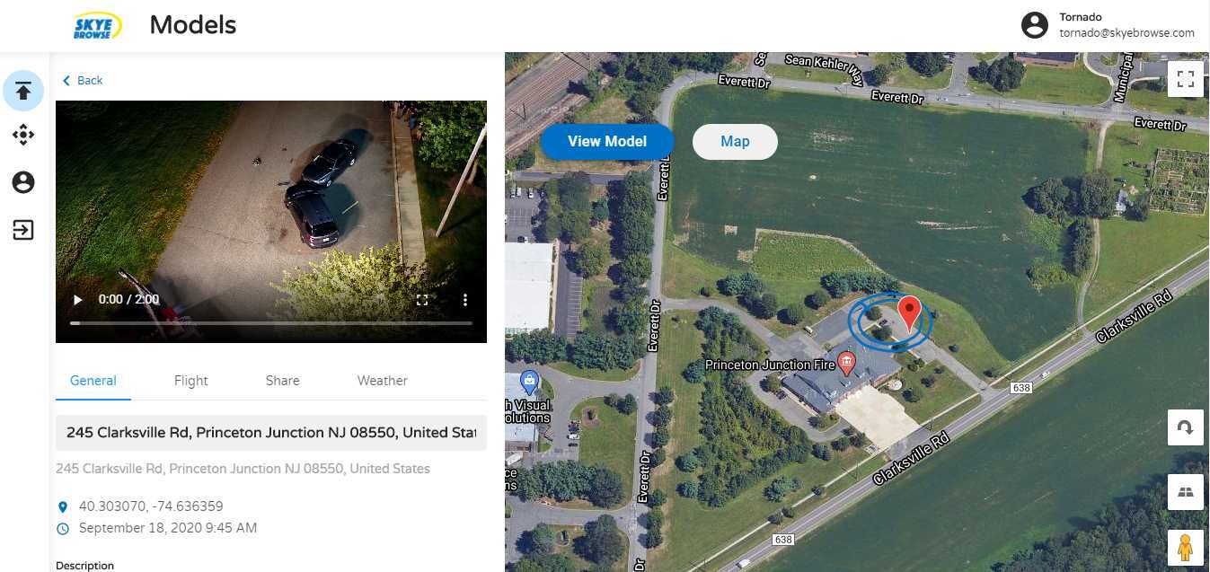
SkyeBrowse's Universal Upload feature accepts .MP4 and .MOV video files from any compatible mapping drone, processes them through the videogrammetry pipeline on US-based AWS Cloud (FedRAMP Impact Level 2) infrastructure, and returns orthomosaics, 3D models, and measurement tools through the browser-based viewer at app.skyebrowse.com — no desktop installation required. Telemetry subtitle files (.SRT from DJI drones, .ASS from Autel) improve georeferencing accuracy when uploaded alongside the video.
What Are the Best Drones for Surveying and Mapping?
The best drone for surveying and mapping is the one that matches your site size, accuracy requirement, and budget — there is no single winner across every project. Most professional survey programs standardize on one of three platform classes:
- RTK-enabled professional multi-rotors — the workhorse tier for most engineering and construction sites. Models such as the DJI Matrice 350 RTK, Matrice 4E/4T, and the DJI Phantom 4 RTK class pair onboard RTK with mechanical or mapping-grade cameras, delivering centimeter-level positioning on sites up to a few hundred acres.
- Prosumer mapping drones — the DJI Mavic 3 Enterprise and Mavic 3 Pro hit a strong price-to-capability ratio for smaller sites, progress monitoring, and teams capturing video for videogrammetry. They lack survey-grade RTK on every variant but pair well with ground control points.
- Fixed-wing and VTOL platforms — for large linear corridors (pipelines, roads, transmission lines) and tracts above roughly 200 acres, fixed-wing and hybrid VTOL aircraft cover far more ground per battery than a multi-rotor, at the cost of needing takeoff and landing space.
A capture drone is only half the equation — the processing software determines how fast the imagery becomes a usable deliverable and which drones you can actually use. SkyeBrowse is drone-agnostic: its Universal Upload accepts video (.MP4, .MOV) from any of these platforms, including consumer drones the Flight App does not automate, so survey teams are not locked into a single manufacturer. Uploading the drone's GPS subtitle file (.SRT for DJI, .ASS for Autel) alongside the video automatically georeferences the resulting model. For a deeper comparison of platforms, see our guide to the best drone mapping software for surveyors.
What Are the Regulatory Requirements for UAV Surveys?
In the United States, commercial drone surveying requires FAA Part 107 Remote Pilot certification. Part 107 governs all commercial UAS operations and sets baseline rules for operating below 400 feet AGL, within visual line of sight, during daylight hours, and away from controlled airspace without authorization per FAA Part 107 regulations.
Key Part 107 compliance requirements for surveying operations:
- Remote Pilot Certificate (sUAS): required for any pilot compensated for drone survey work
- Airspace authorization: operations within controlled airspace (Class B, C, D, E) require LAANC approval or a waiver
- Waivers: beyond visual line of sight (BVLOS) operations require a separate FAA waiver and are uncommon for typical survey work
- Registration: all drones over 0.55 lbs must be registered with the FAA
Beyond federal rules, state licensing boards in most states require that topographic surveys and boundary surveys used for legal or engineering purposes be certified by a Licensed Professional Land Surveyor (PLS or RPLS), regardless of the data collection method. A drone operator without a survey license can collect data; only a licensed surveyor can certify the deliverable. This regulatory distinction shapes how drone survey firms structure their teams — many pair a certified drone pilot with a licensed surveyor who reviews the outputs and stamps the deliverables.
The USGS and state DOTs maintain their own accuracy standards for survey data used in infrastructure projects. Federal highway projects, for example, often require compliance with ASPRS Positional Accuracy Standards for Digital Geospatial Data, which define accuracy classes for orthoimagery and elevation products used in government mapping.
Which Industries Use Drone Surveying?
Drone surveying has displaced traditional ground methods across a wide range of industries wherever large-area, high-frequency, or rapid-response data collection provides a competitive or safety advantage.
- Construction: Site topo, grading verification, volume calculations, progress monitoring against design surfaces. Monthly or weekly flights catch deviations before they compound into expensive rework.
- Civil engineering and land development: ALTA improvement surveys, floodplain analysis, corridor mapping for roads and utilities. Drone data reduces field time for preliminary design by 50-70%.
- Mining and aggregates: Stockpile volume measurement, pit progression mapping, haul road condition monitoring. Accurate volume data tightens reconciliation between production and sales.
- Agriculture: Field boundary mapping, drainage analysis, soil variability mapping with multispectral sensors. The USDA's Farm Service Agency uses aerial imagery for crop acreage reporting, and drone surveys complement that program with higher-resolution field-level data.
- Emergency response and public safety: Rapid scene documentation after accidents, fires, disasters, and criminal incidents. Drone survey of a crash scene can reopen a highway in 30-60 minutes versus 2-4 hours with traditional survey methods.
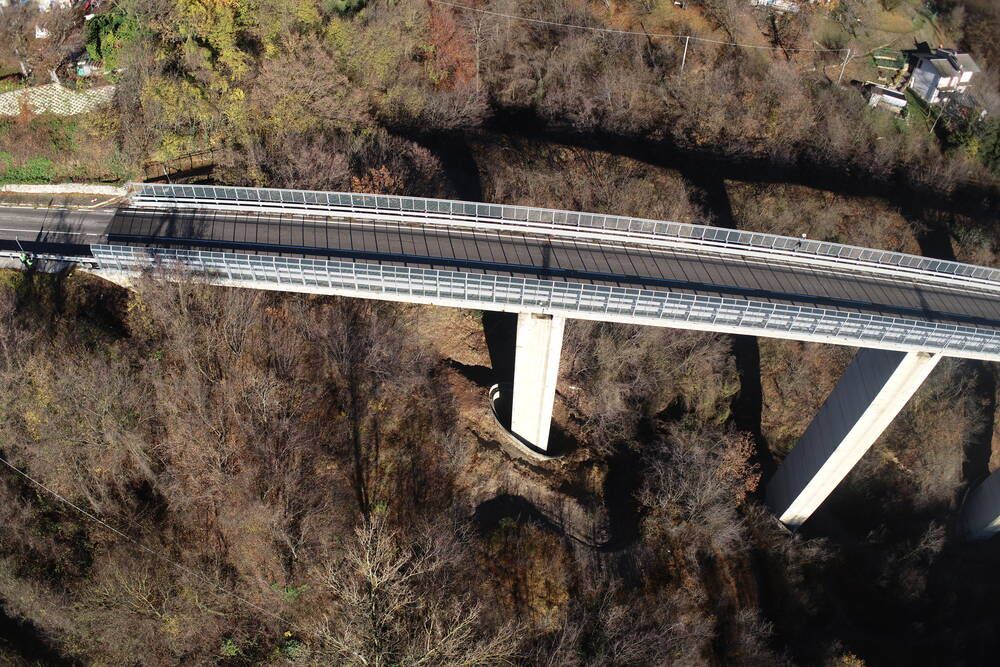
- Infrastructure inspection: Bridge deck surveys, pipeline corridor mapping, utility right-of-way inspection. Drones reach difficult-access locations without scaffolding or boat crews.
- Insurance and risk: Property damage assessment after storms, wildfires, and floods. Drone-derived orthomosaics provide defensible, timestamped condition documentation for claims adjustment.
Drone Surveying Case Examples
These anonymized project summaries reflect typical scope, results, and turnaround times reported across commercial drone survey engagements.
Construction stockpile volume — 50-acre aggregate facility. A regional quarry operator needed monthly volume reconciliation across 12 stockpiles totaling roughly 50 acres. A single pilot flying a multi-rotor with mechanical shutter camera covered the full site in two battery cycles (approximately 70 minutes of flight time). Processing returned a georeferenced orthomosaic and per-pile volume report within 3 hours of data upload. Horizontal accuracy held to 2.5 cm RMSE against RTK check points; vertical accuracy was 3.8 cm RMSE — well within Class 1 tolerances for volumetric reporting. Total deliverables: DEM, stockpile-by-stockpile volume CSV, and a comparison overlay against the prior month's model showing net gain/loss per pile. Field-to-deliverable elapsed time: one workday.
Linear utility right-of-way — 5-mile transmission corridor. A utility contractor needed a topographic base for a transmission line realignment study crossing mixed farmland and light woodland. A hybrid VTOL platform flew two 2.5-mile strips at 180 ft AGL, completing the corridor in 90 minutes across three battery sets. GCPs were placed at 600 m intervals using an RTK rover referenced to the state plane network. The point cloud returned 80–120 points per square meter in open areas; canopy gaps in the wooded sections required a supplemental ground shot along the center-line for accurate terrain modeling below tree cover. Final deliverables: 1 ft contour DXF, LAZ point cloud, GeoTIFF orthomosaic at 4 cm GSD, and a cross-section series at 100 m stations. Accuracy class: ASPRS Class 2 vertical. Total elapsed time: two field days (flight plus GCP survey) plus a half-day of office processing.
Residential subdivision lot survey — 35-lot plat. A civil engineering firm supporting a 35-lot residential subdivision used a drone survey to generate the topographic base for grading and drainage design. The 22-acre site flew in 35 minutes with 8 GCPs. Output resolution was 2.8 cm GSD at 120 ft AGL. Elevation data was used to model detention basin sizing and inlet spacing, replacing what would have been two days of total-station grid shots. The drone-derived 1 ft contours matched traditional survey spot shots to within 0.08 ft at 18 of 20 independent check points — within the project's specified tolerance. Deliverables: contour DXF, grading surface TIN, and a georeferenced PDF base map for the site plan submittal.
What Deliverables Does a Drone Survey Produce?
A standard drone survey workflow produces several output types, each serving a different downstream use — see our orthomosaic vs 3D model guide for how to match the deliverable to the end use.
- Orthomosaic (GeoTIFF): A geometrically corrected, georeferenced aerial image mosaic with consistent scale. Importable into any GIS platform. Used for planimetric mapping, boundary documentation, and base map creation.
- Digital Elevation Model (DEM): A rasterized surface representing ground elevation at each pixel. Used for contour generation, drainage analysis, cut/fill calculations, and floodplain modeling.
- Point Cloud (LAZ/LAS): A dense 3D dataset of millions of measured points, each with X, Y, Z coordinates and RGB color values. Imports into Civil 3D, Revit, Trimble Business Center, and most CAD/BIM platforms. Used for surface modeling, volume calculation, and as-built documentation.
- 3D Mesh (GLB/OBJ): A textured 3D model of the site surface. Used for visualization, courtroom presentations, insurance claims, and public communication of project scope.
- 2D Drawings (PDF/DXF): Site plans, contour maps, and cross-section drawings extracted from processed data and prepared in CAD. Required format for engineering submissions and building permits.
- Measurements and annotations: Distance, area, angle, and elevation measurements extracted directly from the processed model. Platforms like SkyeBrowse provide browser-based measurement tools at app.skyebrowse.com, enabling teams to review and annotate models without desktop software.
The right export format depends on the project deliverable requirement. Survey firms submitting to a state DOT need GeoTIFF orthomosaics and LAZ point clouds. A construction contractor verifying earthwork volumes needs DEM-based cut/fill reports. An insurance adjuster documenting storm damage needs a georeferenced orthomosaic and timestamped 3D model. Match the export tier and format to the end use.
Ready to see how SkyeBrowse's videogrammetry platform fits into your drone surveying workflow? Request a quote to discuss your project requirements.