Warehouse mapping — producing accurate, measurable 3D documentation of a facility's interior — traditionally required professional surveyors, weeks of scheduling, and thousands of dollars per building. Videogrammetry (the process of reconstructing 3D geometry directly from video footage) has changed that calculus entirely. With SkyeBrowse, a facilities manager can walk a distribution center during an off-shift, upload the footage from a smartphone, and review a navigable 3D model with real-world dimensions before the next morning's standup.
Key Takeaways
- A warehouse walkthrough captured on a smartphone processes into a measurable 3D model in roughly the same time it took to film — no survey crew, no shutdown.
- Premium-tier accuracy of approximately 0.25 inch is sufficient for rack spacing verification, forklift clearance documentation, and OSHA aisle-width compliance records.
- Traditional facility surveys cost $2,000–$5,000 per building with 1–2 week turnaround; in-house videogrammetry compresses that to under $100 and same-day results.
- Exported LAZ point clouds and GLB mesh files load directly into AutoCAD, Revit, and leading warehouse management systems for layout planning and equipment procurement.
- Archived models stored on AWS-hosted cloud infrastructure provide time-stamped evidence of facility conditions for lease disputes, insurance claims, and safety audits.
Contents
- Why does traditional warehouse documentation fall short?
- How does videogrammetry work for interior facility mapping?
- What accuracy tier do logistics facilities actually need?
- How does 3D warehouse documentation support OSHA and lease compliance?
- Where else in the logistics operation does spatial documentation pay off?
- FAQ
Why does traditional warehouse documentation fall short?
Traditional warehouse surveys rely on laser rangefinders, tape measures, and manual sketching — a process that takes 1–2 days per building, disrupts operations, and produces static 2D floor plans. Those plans go out of date the moment rack configurations change, and they contain no vertical dimension data for ceiling clearances or mezzanine heights.
Most logistics operators work from floor plans that are years old, hand-annotated with lease amendments, and missing the forklift clearance dimensions that matter most. When a new tenant inherits a building or an operations team inherits a new DC, they often discover that the "as-built" drawings don't match reality by several feet.
The problem compounds at scale. A regional 3PL managing a dozen distribution centers must schedule survey crews across inbound shifts and peak seasons — a coordination effort that pushes most multi-site operators into making rack procurement and layout decisions based on incomplete spatial data, resulting in change orders, wasted cubic capacity, and OSHA citations.
The OSHA General Industry Walking-Working Surfaces standard sets specific dimensional requirements for aisles, exits, and egress paths. Demonstrating compliance requires documented measurements, not employee recollection.
How does videogrammetry work for interior facility mapping?
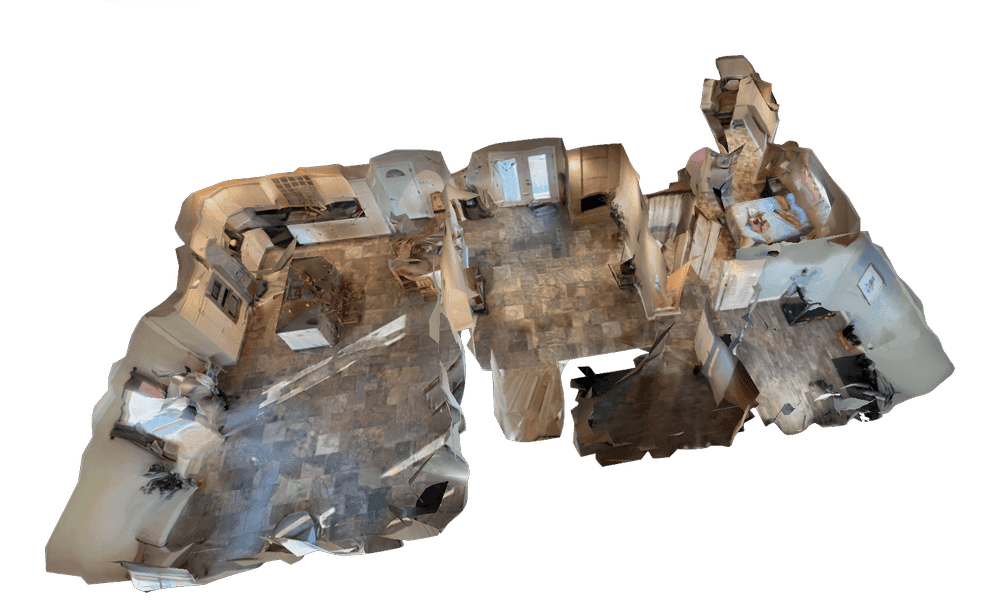
Videogrammetry reconstructs 3D geometry by analyzing overlapping frames from a continuous video stream. As the camera moves through a space, the platform identifies matching features across frames, calculates the geometry between viewpoints, and assembles those calculations into a dense, measurable point cloud and mesh. The result is a navigable 3D model where any two points can be measured directly.
For warehouse documentation, the capture workflow is straightforward: walk main aisles at a consistent pace while filming continuously with a smartphone, action camera, or 360-degree camera. No tripod setups, no static photo stations, no mission planning. Cover primary aisles first, then cross-aisles, dock doors, and any mezzanine levels. A 100,000-square-foot distribution center typically takes 20–30 minutes to capture.
Upload the footage to app.skyebrowse.com via the Universal Upload portal. Processing returns a complete 3D model — point cloud and mesh — in roughly the time it took to walk the facility. The facilities manager can measure aisle widths, verify ceiling heights, check dock door dimensions, and confirm rack depths from the browser before lunchtime.
The GLB mesh model and LAZ point cloud export directly into AutoCAD, Revit, SketchUp, and most warehouse management platforms. Planners overlay proposed rack configurations on actual facility geometry, test aisle modifications against forklift turning radii, and calculate cubic storage capacity from verified dimensions — not from a hand-annotated sketch. For a deeper look at how this workflow compares to photogrammetry-based approaches, see the videogrammetry vs photogrammetry comparison.

What accuracy tier do logistics facilities actually need?
For most rack layout and clearance verification work, Premium-tier accuracy of approximately 0.25 inch (8K processing) is more than adequate. Lease disputes and legal documentation requiring tighter tolerances can use Premium Advanced at approximately 0.1 inch (16K), while preliminary site assessments and vacancy documentation work well at the Lite tier with 2–6 inch relative accuracy.
Matching the accuracy tier to the task matters both for output quality and processing cost. Here is how logistics teams typically map requirements to tiers:
Lite (approximately 2–6 inch accuracy): Best for initial feasibility surveys of candidate buildings, documenting move-out conditions before lease expiration, or generating a visual reference model for stakeholder presentations. At this tier, the model communicates layout and configuration but shouldn't be used for precise equipment procurement.
Premium (approximately 0.25 inch at 8K): The workhorse tier for active operations. Verifies rack spacing against fire code and OSHA aisle requirements, confirms forklift clearances for equipment procurement, calculates cubic storage capacity, and documents conditions for insurance purposes. At $99 per model credit, a single Premium model covers a facility comprehensively.
Premium Advanced (approximately 0.1 inch at 16K): Used when dimensions carry legal or contractual weight. Landlord disputes over rentable versus usable square footage, property acquisition due diligence, and post-incident reconstruction for liability investigations all benefit from this level of fidelity.
For multi-building campuses, capture each warehouse separately to keep model sizes manageable. The drone as-built documentation guide covers how to annotate and link separate building models for a unified campus reference.
How does 3D warehouse documentation support OSHA and lease compliance?
A time-stamped 3D model functions as objective, spatial evidence of facility conditions on a specific date. When an OSHA inspector questions aisle widths or a landlord disputes damage at lease end, the archived model shows actual dimensions — not a tenant's estimate or a landlord's recollection. That evidence base reduces citation disputes and supports lease negotiations with verifiable data.
OSHA's 29 CFR 1910.22 requires that aisles used for material handling be at least 3 feet wider than the largest equipment used. Proving compliance with a tape measure recorded in a spreadsheet is defensible in theory, but fragile in practice. A georeferenced 3D model showing measured aisle widths, annotated with equipment dimensions, is a substantially stronger compliance record — one that holds up when personnel change and institutional memory fades.
On the lease side, the gap between "rentable area" and "usable area" commonly runs 10–20% in industrial real estate. When landlords calculate rent on rentable area that includes common spaces a tenant can't actually rack, the difference on a 200,000-square-foot lease can represent $50,000 or more annually. A Premium Advanced model documents the actual usable cubic footage of a facility, giving tenants objective grounds to challenge inflated rentable-area claims.
Multi-tenant logistics parks benefit from controlled model sharing. Property managers grant insurance adjusters, prospective tenants, and maintenance contractors access to specific building models via secure links — eliminating the need to coordinate site visits for every stakeholder review. Cloud storage on AWS-hosted infrastructure ensures models remain accessible for the duration of a 5–10 year commercial lease term.
For incidents — forklift collisions, rack failures, slip-and-fall events — the pre-existing facility model serves as baseline evidence for root cause analysis. Investigators measure actual aisle widths, sight-line obstructions, and equipment positions against the as-documented facility conditions at the time of the incident. See how this pairs with formal drone forensic engineering workflows for incident documentation.
Where else in the logistics operation does spatial documentation pay off?
Beyond compliance, 3D warehouse documentation accelerates equipment procurement, reactive capacity planning, property acquisition due diligence, and safety training — any workflow that depends on knowing the exact geometry of a facility before committing time or capital.
Equipment procurement: Rack manufacturers, conveyor installers, and forklift vendors need accurate facility constraints to quote and specify equipment correctly. Providing a GLB model instead of a hand-drawn sketch eliminates the dimensional surprises that generate change orders and installation delays.
Reactive capacity planning: When customer demand spikes unexpectedly, a current 3D model lets the operations team identify available floor positions, verify clearances for temporary racking, and place equipment orders based on confirmed geometry — all within the same day. This pairs naturally with disaster response mapping workflows where pre-incident spatial data informs rapid response planning.
Property acquisition: Buyers evaluating warehouse acquisitions can capture multiple candidate buildings rapidly, compare cubic storage efficiency across properties, and make offers informed by verified operational fit rather than broker-provided floor plans.
Material handling optimization: Warehouse planners use the point cloud to model putaway strategies, calculate travel distances between storage zones, and simulate throughput scenarios based on actual geometry. For construction teams adding logistics space to an existing facility, the 3D mapping for construction guide covers combining interior and exterior models for full-site documentation.

FAQ
Can I use SkyeBrowse inside a warehouse without a drone?
Yes. SkyeBrowse accepts video from any smartphone, action camera, or 360-degree camera. Walk the aisles at a steady pace while filming continuously, upload the footage to app.skyebrowse.com, and the platform returns a navigable 3D model. No drone, no tripod, no professional survey crew required.
How accurate is warehouse videogrammetry for measuring rack clearances?
At the Premium tier, SkyeBrowse delivers approximately 0.25-inch accuracy at 8K resolution — sufficient for verifying rack spacing, aisle widths, and forklift clearance requirements. For lease negotiations or legal documentation requiring tighter tolerances, Premium Advanced achieves approximately 0.1-inch accuracy at 16K resolution.
How long does it take to document a 100,000-square-foot warehouse?
A typical 100,000-square-foot warehouse can be walked and filmed in roughly 20–30 minutes. Cloud processing returns a complete 3D model in approximately the same time. Most facilities are fully documented — from walkthrough to model-in-hand — within a single work session, compared to 1–2 weeks for a traditional survey.
What file formats does SkyeBrowse export for warehouse planning software?
SkyeBrowse exports LAZ (point cloud) for import into AutoCAD, Revit, and warehouse management systems, GLB (3D mesh) for browser-based viewing and CAD overlays, and GeoTIFF (orthomosaic) for 2D floor plan derivation. These formats cover the most common facility planning and BIM workflows.