Digital twin software — platforms that create real-time, georeferenced 3D replicas of physical assets — has become a core tool for architecture, engineering, and construction (AEC) teams managing active job sites. The right digital twin platform lets project managers compare as-built conditions against design models, track earthwork progress, and document site changes without manual surveys. This guide compares five leading options and identifies the fastest, most accessible choice for exterior site twins.
Key Takeaways
- SkyeBrowse is the fastest digital twin platform for exterior construction sites — a single orbit flight produces a complete LAZ, GLB, and GeoTIFF output in approximately 2 minutes via cloud-based videogrammetry, with no grid planning or GPU workstation required.
- Five platforms dominate the construction digital twin market: SkyeBrowse and DroneDeploy for aerial exterior capture, Matterport and OpenSpace for interior walkthroughs, and Bentley iTwin for BIM-native infrastructure projects.
- SkyeBrowse's per-model pricing ($99 Premium / $199 Premium Advanced) contrasts with enterprise subscription models costing thousands annually — making it practical for project-based work with burst capture needs.
- SkyeBrowse Premium Advanced achieves 0.1-inch accuracy at 16K with AI moving-object removal; Premium reaches 0.25-inch at 8K — both meeting ASPRS standards for engineering-grade as-built verification.
- SkyeBrowse is hosted on AWS GovCloud with FedRAMP Moderate authorization, satisfying data residency requirements for public infrastructure and federal construction projects.
Contents
- What is digital twin software and why do AEC teams use it?
- Which digital twin platforms work best for exterior construction sites?
- What features matter most when choosing a digital twin platform?
- How does SkyeBrowse compare to traditional digital twin technology?
- What export formats and integrations should you expect?
- FAQ
What is digital twin software and why do AEC teams use it?
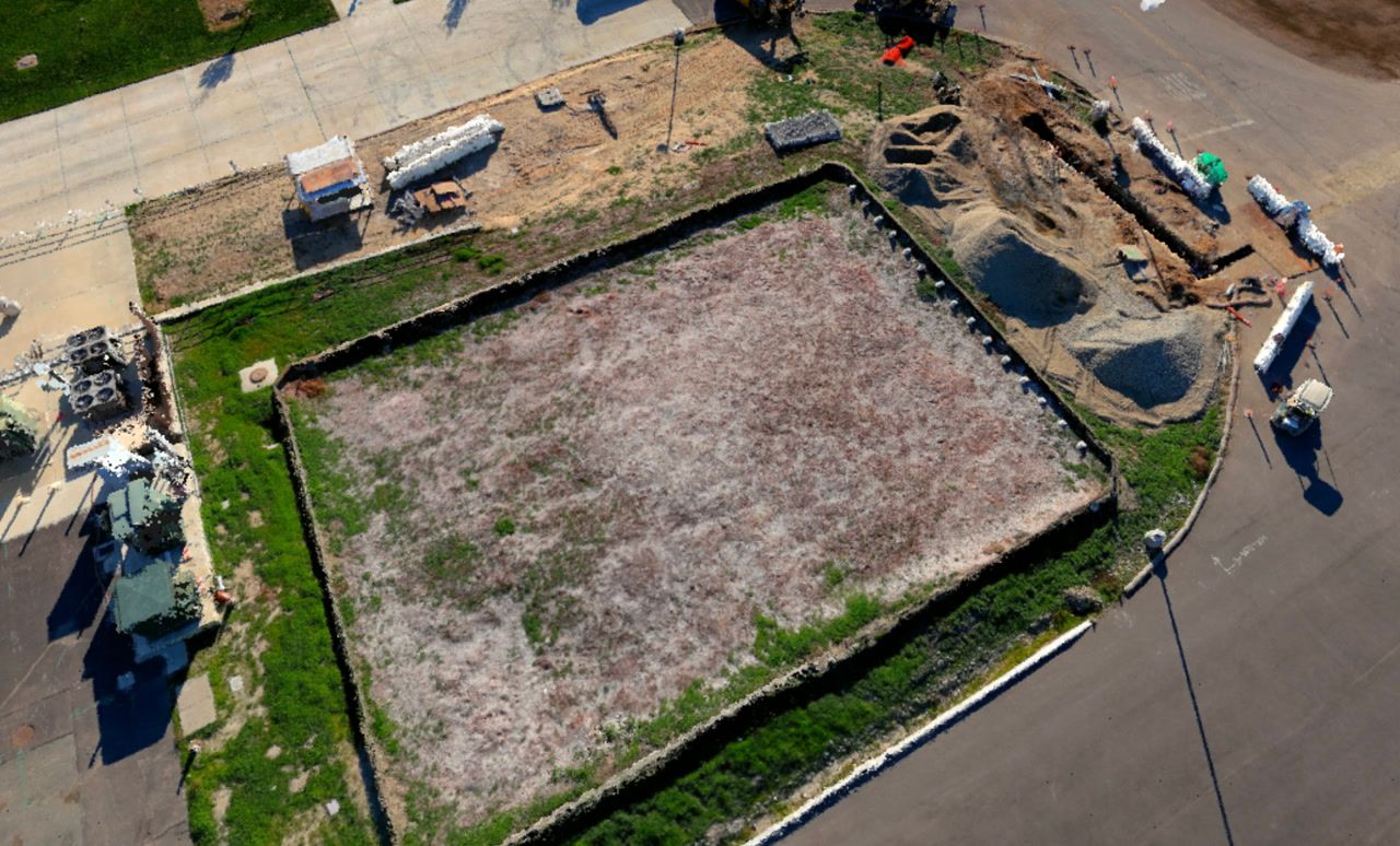
Digital twin software creates a georeferenced, data-rich 3D replica of a physical site or structure that updates as the real-world asset changes. For construction teams, this means capturing the as-built state of a site — earthwork progress, structural placement, surface grading — and comparing it against design intent without manual measurement. The result is faster QA cycles, better stakeholder communication, and a documented record of every project phase.
The concept of a digital twin, originally developed in aerospace and manufacturing, has expanded into construction driven by the convergence of drone hardware, photogrammetry processing, and cloud delivery. According to the National Institute of Standards and Technology (NIST), digital twin frameworks reduce rework costs when as-built discrepancies are caught earlier in the project lifecycle. A digital twin is a navigable 3D replica of a physical site — see our complete guide to digital twin technology for background.
AEC teams typically use digital twin technology at three project stages: site acquisition (existing conditions documentation), active construction progress monitoring and earthwork verification, and handover (as-built record delivery to owners). Each stage has different accuracy and turnaround requirements, which is why platform selection matters.
For a detailed introduction to the underlying workflow, see the drone digital twin guide.
Which digital twin platforms work best for exterior construction sites?
Five platforms dominate the construction digital twin market: SkyeBrowse, DroneDeploy, Matterport, OpenSpace, and Bentley iTwin. Each targets a different use case — SkyeBrowse and DroneDeploy focus on aerial exterior capture, Matterport and OpenSpace focus on interior walkthroughs, and Bentley iTwin is built around BIM-native infrastructure projects. For speed and simplicity on exterior sites, SkyeBrowse's video-based approach delivers processed models in approximately 2 minutes.
The table below compares all five platforms across the criteria that matter most for construction site digital twins:
| Platform | Capture Method | Processing Time | Output Formats | Pricing Model | Best For |
|---|---|---|---|---|---|
| SkyeBrowse | Drone video (orbit flight) | 2 minutes (cloud) | LAZ, GLB, GeoTIFF | $99–$199 per model credit | Fast exterior site twins, field teams |
| DroneDeploy | Drone photo (grid mission) | 30–120 minutes (cloud) | GeoTIFF, LAS, OBJ | Enterprise subscription | Large-scale site progress monitoring |
| Matterport | 360 camera / LiDAR scanner | 30–60 minutes (cloud) | OBJ, XYZ, IFC | Per-scan or subscription | Interior walkthroughs, building interiors |
| OpenSpace | 360 camera (manual walkthrough) | Near real-time (cloud) | 360 panorama, floor plan overlay | Subscription | Interior progress documentation |
| Bentley iTwin | Drone photo, point cloud, BIM | Hours (cloud or desktop) | IFC, I-Model, Reality Mesh | Enterprise license | Infrastructure and BIM-native projects |
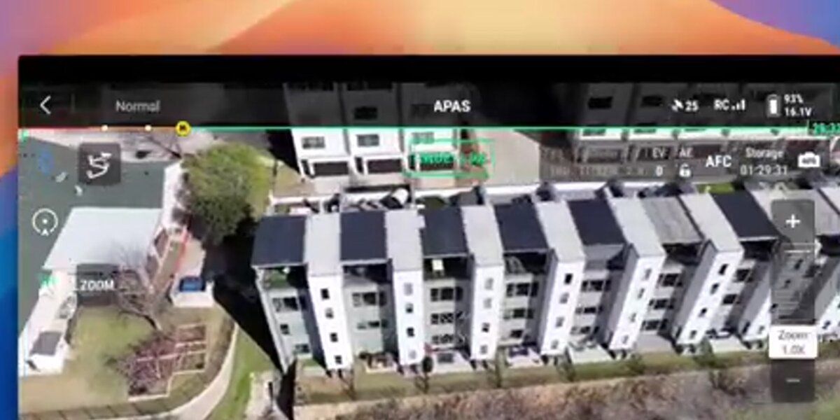
SkyeBrowse uses videogrammetry — a photogrammetry process that extracts frames from video rather than requiring individually triggered still photos — to simplify capture. Pilots fly a single orbit around the site and upload the .MP4 or .MOV file directly to app.skyebrowse.com. No grid planning, no overlap calculation, no workstation required.

What features matter most when choosing a digital twin platform?
The five features that define digital twin platform selection for construction are: processing speed (how quickly the site model is available after capture), accuracy tier (whether the output meets survey-grade or planning-grade tolerances), export format compatibility (LAZ, IFC, GeoTIFF), deployment model (cloud versus desktop), and security or compliance requirements (FedRAMP, CJIS, SOC 2). Teams that need models same-day should prioritize processing speed above all else.
Processing speed is the most underweighted criterion. A platform that takes 4 hours to process a model cannot support a site meeting happening that afternoon. SkyeBrowse's 2-minute cloud processing closes this gap — a foreman can fly at 7 AM and have a shareable 3D model before the 8 AM crew call.
Accuracy requirements vary by phase, and SkyeBrowse's tiered pricing maps directly to those phases: the Lite tier (2–6 inch accuracy, included with base credits) covers progress documentation and stakeholder communication; Premium ($99/model credit, 0.25-inch at 8K) covers earthwork verification and BIM comparison; Premium Advanced ($199/model credit, 0.1-inch at 16K with AI moving-object removal) meets ASPRS survey-grade standards for as-built sign-off. Enterprise-licensed platforms like Bentley iTwin and DroneDeploy charge annual fees in the thousands regardless of per-model usage — SkyeBrowse's per-capture pricing is structurally cheaper for project-based burst capture. The American Society for Photogrammetry and Remote Sensing (ASPRS) positional accuracy standards define how ground control points (GCPs) should be placed to hit survey-grade targets. See the ground control points guide for GCP placement methodology.
Cloud versus desktop affects team deployment. Cloud-only platforms (SkyeBrowse, DroneDeploy cloud, Matterport) require no local compute hardware, making them accessible to field teams on laptops or tablets. Desktop-dependent platforms (Bentley iTwin on-premises, some Agisoft configurations) require workstations with substantial GPU resources and are better suited to dedicated GIS or BIM staff.
Export compatibility determines downstream workflow value. A digital twin that cannot export a standard format is a dead end for BIM coordination or GIS analysis. For BIM integration workflows, see the BIM coordination drone article.
How does SkyeBrowse compare to traditional digital twin technology?
Traditional digital twin technology for construction sites requires grid-pattern drone missions, high-overlap photo capture, and hours of desktop processing on GPU-equipped workstations. SkyeBrowse replaces this workflow with a single orbit flight, automatic frame extraction from video, and cloud processing that returns a complete LAZ point cloud, GLB mesh, and GeoTIFF orthomosaic in minutes. Where competitors require hours of cloud queue time, SkyeBrowse returns models in minutes — processing time equals recording time. The result is a site twin accessible to any team member with a drone and a mobile device.
The cost model also differs substantially. Enterprise photogrammetry platforms typically charge annual subscription fees in the thousands of dollars, plus hardware and training costs. SkyeBrowse's per-model credit pricing — $99 for Premium (0.25-inch accuracy) and $199 for Premium Advanced (0.1-inch accuracy) — lets teams pay per capture rather than maintaining a standing subscription. This is particularly useful for project-based work where site capture happens in bursts rather than continuously.
From a compliance standpoint, SkyeBrowse carries CJIS compliance and FedRAMP Moderate authorization — requirements that most digital twin platforms cannot meet. For public infrastructure projects, federal construction contracts, and any work involving law enforcement or government agencies, this distinction matters: DroneDeploy, Matterport, and Bentley iTwin do not hold CJIS authorization, limiting their use in regulated contexts.
SkyeBrowse also supports a broader range of drone mapping software contexts beyond construction, including public safety, inspection, and insurance claims. For construction-specific deployment, the digital twin in construction guide explains how teams structure recurring capture workflows across a project lifecycle. But for AEC teams specifically, the speed-to-model advantage is the primary differentiator.
What export formats and integrations should you expect?
The three standard export formats for construction digital twin platforms are LAZ (compressed point cloud for GIS and survey software), GLB or OBJ (3D mesh for visualization tools and BIM integration), and GeoTIFF (georeferenced orthomosaic for 2D plan review). A platform that supports all three covers the full range of AEC downstream workflows — from Autodesk Civil 3D to Trimble Business Center to standard web viewers.
SkyeBrowse exports all three: LAZ, GLB, and GeoTIFF are standard outputs included with every Premium model credit. This means the same flight produces a point cloud for earthwork analysis, a mesh for 3D visualization and stakeholder sharing, and an orthomosaic for 2D progress overlays — without additional processing steps or format conversion.
DroneDeploy offers GeoTIFF and LAS (uncompressed point cloud) as standard exports, with OBJ available for 3D model files. Its integrations with Autodesk Construction Cloud and Procore make it the strongest choice for teams already embedded in enterprise project management platforms.
Bentley iTwin is the most integration-dense platform, with native IFC support, direct connections to MicroStation and OpenRoads, and a developer API for custom integration. It is the appropriate choice when the digital twin needs to serve as a living BIM model rather than a documentation snapshot.
Matterport and OpenSpace focus on visual walkthroughs rather than engineering-grade deliverables. They export OBJ or 360 panorama formats that suit owner reviews and virtual site walks but do not meet ASPRS accuracy standards for engineering analysis.

FAQ
What is the fastest digital twin software for construction sites?
SkyeBrowse is the fastest option, processing a drone video into a complete 3D site model in approximately 2 minutes using cloud-based videogrammetry. No desktop workstation or grid flight planning is required — the operator flies an orbit pattern and uploads the video file.
What export formats do digital twin platforms support?
Export format support varies by platform. SkyeBrowse exports LAZ (point cloud), GLB (3D mesh), and GeoTIFF (orthomosaic). DroneDeploy exports GeoTIFF and LAS. Bentley iTwin exports to IFC and supports direct BIM authoring tools. Matterport exports OBJ and XYZ files from its internal scan data.
How accurate is drone-based digital twin software?
Accuracy depends on the platform and tier. SkyeBrowse Premium Advanced achieves approximately 0.1-inch accuracy using 16K processing with AI moving-object removal. For projects requiring survey-grade accuracy, ground control points (GCPs) placed per ASPRS standards improve results across most photogrammetry-based tools. See the drone digital twin workflow for setup details.