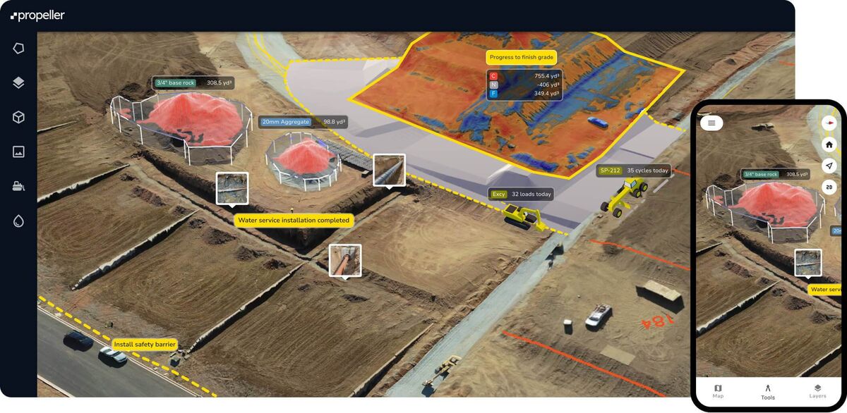
Propeller Aero is an Australian construction and mining drone mapping platform built around recurring site surveys using proprietary AeroPoint GNSS ground control hardware. It requires DJI drones, $10,000-$21,000 in AeroPoint hardware per site, and hours of processing time. SkyeBrowse takes the opposite approach to drone mapping: patented videogrammetry that turns video from any camera into a 3D model in minutes, with zero proprietary hardware.
Contents
- Which Devices Work with Propeller Aero vs SkyeBrowse?
- How Fast Does Propeller Aero Process Compared to SkyeBrowse?
- What Site Preparation Does Propeller Aero Require vs SkyeBrowse?
- How Accurate Is Propeller Aero Compared to SkyeBrowse?
- How Much Does Propeller Aero Cost vs SkyeBrowse?
- Is Propeller Aero CJIS Compliant?
- What Formats Does Propeller Aero Export vs SkyeBrowse?
- Drone Mapping Platform Comparison
- The Bottom Line
- Related Comparisons
- Get a SkyeBrowse Recommendation
Propeller Aero vs SkyeBrowse: Pricing & Features at a Glance
Propeller Aero does not publish list pricing. Subscription and hardware figures below are estimates compiled from publicly reported customer accounts and historical AeroPoint retail prices — confirm directly with Propeller for current quotes.
| Feature | Propeller Aero | SkyeBrowse |
|---|---|---|
| Hardware required | DJI drone + 5-7 AeroPoint GNSS markers per site | None — any drone, phone, GoPro, or BWC |
| Site prep time | 30-60 min to deploy ground control before each capture | Zero — record and go |
| Processing speed | 4-12 hours (overnight cloud pipeline) | ~1:1 real-time (10-min video → 10-min model) |
| Per-site subscription | $5,000-$10,000/site/year | No per-site fee; usage-based credits or flat subscription |
| Hardware cost per site | $10,000-$21,000 (AeroPoint units) | $0 (leverages existing cameras) |
| Annual cost — 3 sites | $45,000-$93,000 (subscriptions + hardware) | Scales with model volume, not site count |
| Drone compatibility | DJI only | Any drone brand (.MP4/.MOV) |
| Output formats | GeoTIFF, LAS (proprietary dashboard) | LAZ, GLB, GeoTIFF — open formats, browser sharing |
| Accuracy class | Centimeter (AeroPoints required) | 0.1 in (Premium Advanced, no GCP hardware) |
| Best fit | Fixed construction/quarry recurring surveys | Multi-site, unplanned, or public-safety capture |
Which Devices Work with Propeller Aero vs SkyeBrowse?
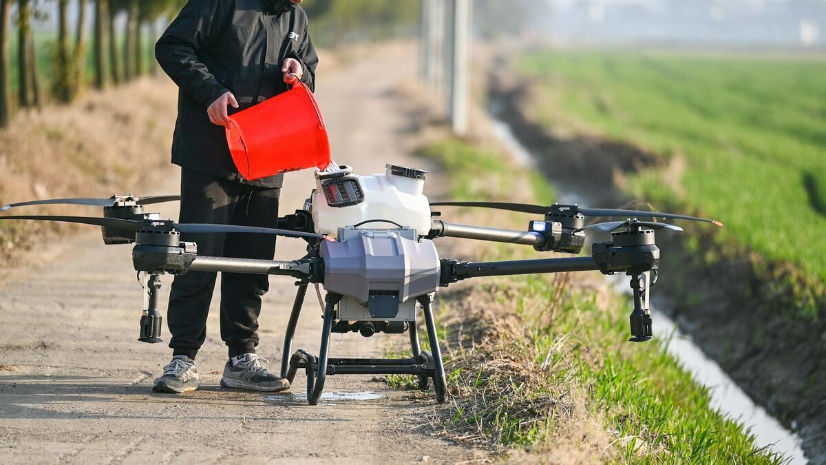
Propeller Aero only processes photos from DJI drones flown over its proprietary AeroPoint ground control markers. SkyeBrowse accepts any .MP4 or .MOV video from any device through Universal Upload, including drones, smartphones, GoPros, body-worn cameras, and 360 cameras. The hardware requirement gap is the widest of any competitor comparison in the drone mapping platform category.
Propeller Aero processes drone photos captured during grid flights over AeroPoint ground control markers. Operators use DJI drones with DJI's native apps or third-party flight tools. There is no support for handheld cameras, smartphones, body-worn cameras, or 360 cameras. If you are not flying a drone over pre-deployed AeroPoints, Propeller cannot generate a model.
SkyeBrowse accepts any .MP4 or .MOV video file from any device. Drone orbits, smartphone walkarounds, GoPro recordings, body-worn camera footage, and 360 camera captures all process through the same videogrammetry engine. No proprietary ground control hardware, no specific drone brand, no flight app dependency. Your team documents with whatever equipment is on hand.
How Fast Does Propeller Aero Process Compared to SkyeBrowse?
Propeller Aero's cloud pipeline takes 4 to 12 hours to deliver a finished map, designed for overnight turnaround on recurring construction surveys. SkyeBrowse processes video at a 1:1 ratio, so a 10-minute capture yields a 3D model in approximately 10 minutes. Teams that need same-visit results cannot afford Propeller's overnight wait.
Propeller's cloud processing takes 4-12 hours depending on dataset size and resolution settings. The platform is designed for recurring surveys where results are reviewed the next morning in an office, not in the field the same hour. A flight captured Monday afternoon may not be available for measurement until Tuesday morning.
SkyeBrowse processes video at a 1:1 ratio. A 10-minute video yields a 3D model in approximately 10 minutes. A site manager captures a volume measurement and reviews results during the same visit. An officer documents a crash scene and has a shareable model before leaving the area. Propeller's processing timeline assumes you can wait overnight. SkyeBrowse's timeline assumes you cannot.
What Site Preparation Does Propeller Aero Require vs SkyeBrowse?
Propeller Aero requires deploying 5 to 7 AeroPoint GNSS markers at surveyed positions before every capture, adding 30 to 60 minutes of setup per survey. SkyeBrowse requires zero site preparation: an operator presses record on any camera and the videogrammetry engine builds the model from the video alone. This makes Propeller impractical for unplanned scenes like crash sites, fires, or ad-hoc insurance inspections.
Propeller requires deploying AeroPoint ground control markers before every capture. A typical site needs 5-7 AeroPoints, each placed at surveyed positions around the perimeter. Setup, flight, and collection takes 30-60 minutes per survey. This works for planned, recurring visits to the same construction site or quarry. It is completely impractical for unplanned drone surveying and mapping: you cannot pre-deploy ground control hardware at a crash scene, fire, or insurance inspection you did not know about yesterday.
SkyeBrowse requires only that someone press record. No ground control deployment, no pre-planned survey, no site preparation. An operator flies a drone orbit, walks with a phone, or clips on a body-worn camera. The videogrammetry engine builds the model from the video alone. Propeller demands 30-60 minutes of site preparation before a single photo is captured. SkyeBrowse is ready the moment the operator arrives.
Need help deciding whether Propeller Aero or SkyeBrowse best fits your field operations? Reach out and we can map the right workflow to your mission, staffing model, and timeline.
How Accurate Is Propeller Aero Compared to SkyeBrowse?
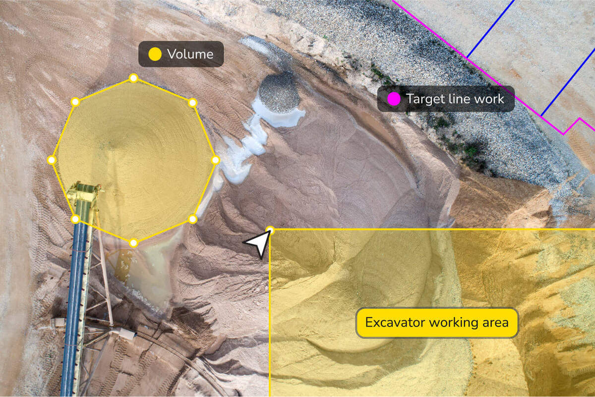
Propeller Aero delivers centimeter-level accuracy, but only when AeroPoint hardware ($10,000-$21,000) is deployed at every capture. SkyeBrowse achieves comparable or better precision through software tiers alone: Lite at 2-6 inch accuracy, Premium at 0.25 inch accuracy with 8K resolution, and Premium Advanced at 0.1 inch accuracy with 16K resolution and AI moving object removal. No proprietary ground control hardware is required at any SkyeBrowse tier.
Propeller achieves centimeter-level accuracy through AeroPoint GNSS corrections. This is genuine survey-grade precision, but it requires the full AeroPoint deployment at every capture. Without AeroPoints, Propeller cannot deliver its accuracy claims. The accuracy is tied to the hardware, not the software.
SkyeBrowse delivers documented accuracy through software tiers, independent of ground control hardware. Lite provides 2-6 inch accuracy for operational documentation. Premium delivers 8K resolution at 0.25 inch accuracy. Premium Advanced delivers 16K resolution at 0.1 inch accuracy with AI moving object removal that strips pedestrians, vehicles, and transient objects from the final model. Propeller's centimeter accuracy requires $10,000-$21,000 in ground control hardware deployed at every site. SkyeBrowse's 0.1 inch accuracy requires uploading a video. For construction volume measurement, SkyeBrowse's SaltBrowse feature calculates volumes from a simple video walkaround, eliminating the AeroPoint cycle entirely.
How Much Does Propeller Aero Cost vs SkyeBrowse?
Propeller Aero charges $5,000 to $10,000 per site per year in subscriptions, plus $10,000 to $21,000 in AeroPoint hardware per site. SkyeBrowse uses per-model credit packs and subscription tiers with no per-site fees and no proprietary hardware investment. A team documenting 20 different locations per month pays a fraction of what Propeller charges for a single fixed site.
Propeller charges per-site subscriptions at $5,000-$10,000 per year per location. AeroPoint hardware is purchased separately at $2,000-$3,000 per unit, and each site requires 5-7 units for proper coverage. A construction company monitoring three active sites faces $15,000-$30,000 per year in subscriptions plus $10,000-$21,000 in AeroPoint hardware. The economics assume recurring surveys at fixed locations where the alternative is hiring survey crews at $1,500-$3,000 per visit. For teams working across many locations, costs multiply fast.
SkyeBrowse pricing scales with usage, not with the number of sites. Per-model credit packs and subscription tiers let teams pay for what they process. There is no per-site fee, no proprietary hardware investment, and no minimum commitment per location. Traditional scene documentation costs roughly $360 in personnel and time. SkyeBrowse reduces that to approximately $25, cutting the process from 3 hours with 4 staff to 10 minutes with 1 operator. A team that documents 20 different locations per month pays a fraction of what Propeller charges for a single site.
Is Propeller Aero CJIS Compliant?
Propeller Aero does not advertise CJIS compliance, FedRAMP authorization, or government-specific cloud hosting. SkyeBrowse runs on AWS GovCloud (US) with FedRAMP Moderate alignment and full CJIS compliance, including audit trails, chain-of-custody controls, and 5-year guaranteed data retention on Premium and Premium Advanced tiers. Agencies handling criminal evidence or crash reconstruction data cannot rely on Propeller's security posture.
Propeller Aero offers standard cloud security appropriate for commercial construction and mining data. It does not advertise CJIS compliance, FedRAMP authorization, or government-specific cloud hosting. Agencies handling criminal evidence, crash reconstruction data, or sensitive law enforcement records cannot rely on Propeller's security posture for chain-of-custody requirements.
SkyeBrowse runs on AWS GovCloud (US) with FedRAMP Moderate alignment and full CJIS compliance. Audit trails, controlled sharing permissions, and chain-of-custody controls come standard. Data retention is guaranteed for 5 years on Premium and Premium Advanced tiers. Propeller was built for commercial construction data. SkyeBrowse was built for data that goes to court.
What Formats Does Propeller Aero Export vs SkyeBrowse?
Propeller Aero exports GeoTIFF and LAS files but keeps most analysis inside its proprietary Propeller Platform dashboard, requiring an account to view data. SkyeBrowse exports LAZ point clouds, GLB meshes, and GeoTIFF orthomosaics in open formats that import into any GIS, CAD, or forensic reconstruction tool. SkyeBrowse also provides a browser-based 3D viewer at app.skyebrowse.com where anyone can review and measure models through a shared link without software or an account.
Propeller produces orthomosaics, point clouds (LAS), and digital surface models within its proprietary web platform. The analytical layer includes volume measurement, cross-section profiles, design surface overlays, and survey-over-survey comparison timelines. Data exports in GeoTIFF and LAS for CAD and GIS tools, but the primary experience is the Propeller Platform dashboard. Integration with Procore feeds progress data into construction project management. Sharing outside the platform requires export.
SkyeBrowse exports LAZ point clouds, GLB meshes, and GeoTIFF orthomosaics. These open formats import into any GIS, CAD, or forensic reconstruction tool. The browser-based 3D viewer lets project managers, prosecutors, adjusters, and partner agencies review and measure models through a shared link without installing software or creating an account. Propeller keeps data in its platform. SkyeBrowse puts data wherever your workflow demands.
Drone Mapping Platform Comparison
| Propeller Aero | SkyeBrowse | |
|---|---|---|
| Device Compatibility | DJI drones over AeroPoints only | Any .MP4/.MOV device |
| Capture Method | Grid flight over pre-deployed ground control | Any video: drone, phone, BWC, 360 camera |
| Site Preparation | 30-60 min AeroPoint deployment per survey | None |
| Processing Time | 4-12 hours | ~1:1 ratio (minutes) |
| Accuracy | Centimeter (requires AeroPoints) | Lite: 2-6 in, Premium: 0.25 in, Advanced: 0.1 in |
| Hardware Cost | $10,000-$21,000 in AeroPoints per site | None (uses existing cameras) |
| Pricing | $5,000-$10,000/site/year + hardware | Per-model credits or subscription (no per-site fee) |
| Compliance | Standard cloud security | CJIS, FedRAMP Moderate, AWS GovCloud |
| Outputs | GeoTIFF, LAS (proprietary dashboard) | LAZ, GLB, GeoTIFF (open formats, browser sharing) |
| Volume Measurement | Design surface overlay, cut/fill tracking | SaltBrowse from video walkaround |
| Data Retention | Platform-dependent | 5-year guaranteed (Premium/Advanced) |
The Bottom Line
Propeller Aero is purpose-built for a single workflow: recurring drone surveys at the same construction site or quarry, tracked over weeks and months with proprietary ground control hardware. If your entire operation is fixed-site earthworks monitoring and you can absorb $10,000-$21,000 in AeroPoint hardware plus $5,000-$10,000 per site per year, Propeller delivers that specific capability.
As drone mapping software, SkyeBrowse wins everywhere else. Any camera instead of DJI drones over AeroPoints. Zero site preparation instead of 30-60 minutes deploying ground control. Minutes of processing instead of hours. Documented accuracy tiers without proprietary hardware dependencies. CJIS compliance and GovCloud hosting that Propeller does not offer. Open export formats and browser-based sharing instead of a proprietary dashboard. Usage-based pricing that does not multiply by the number of locations. Teams running utility infrastructure inspections or bridge inspections benefit from that zero-setup workflow. For public safety, insurance, multi-site construction, and any team that works at a different location each day, SkyeBrowse is the faster, more flexible, more cost-effective platform.
Get a SkyeBrowse Recommendation
If your work takes you to a different site every shift and you need a 3D model from whatever camera is available, SkyeBrowse fits that operational tempo. Public safety, insurance, and multi-site construction teams use it to eliminate hardware dependencies and produce court-ready or field-ready models in minutes.