Property and casualty adjusters balance competing demands — carriers expect fast claim closure controlling loss adjustment expense, while claimants and legal counsel demand thorough documentation justifying settlement values. The adjuster toolkit determines whether field staff document losses comprehensively on first visits or face supplement requests and desk review challenges that delay closure and increase costs. This guide covers the core tool categories, workflow efficiency strategies, and ROI benchmarks for modern adjusting operations.
Contents
- What tools do insurance adjusters need for property claims?
- How does video-based documentation improve adjuster efficiency?
- What is the ROI of upgrading adjuster documentation tools?
- What equipment do adjusters need by claim type?
- How does SkyeBrowse fit into adjuster workflows?
What tools do insurance adjusters need for property claims?
Insurance adjusters need tools across three categories: measurement and estimation (roof estimating platforms, smartphone apps, drone-derived measurements), documentation and evidence (high-resolution photo/video capture, 3D spatial documentation), and communication and coordination (cloud-based sharing platforms for contractor, engineer, and desk review collaboration). The most effective toolkits combine rapid capture with measurement-grade output that feeds directly into estimating software like Xactimate.
Measurement and estimation: Roof estimating platforms (EagleView, HoverConnect) provide rapid square footage calculations but use dated satellite imagery that misses current damage. Smartphone apps (Xactimate mobile, ClaimXperience) support on-site estimating but require manual measurements. Drones add current-condition documentation — processing generates accurate measurements that bridge the gap between rapid satellite estimates and time-intensive manual surveys.
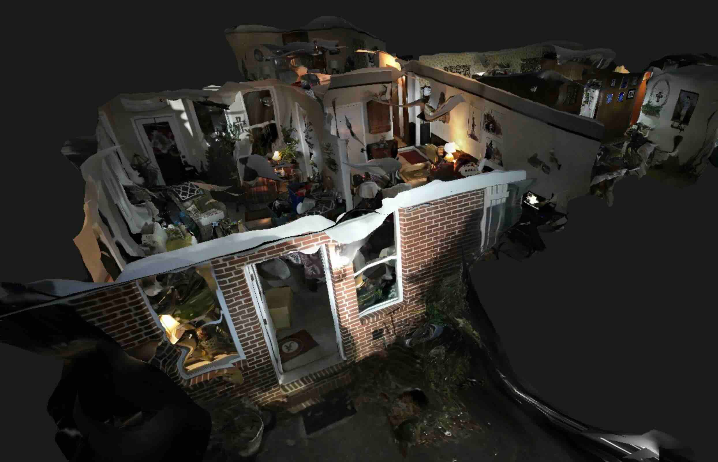
Documentation and evidence: High-resolution photo documentation remains universal, but photos miss spatial context. Video documentation captures how rooms connect, damage relationships, and access constraints. 3D documentation — built from videogrammetry — combines visual completeness with measurement capability, letting adjusters capture once and measure repeatedly rather than returning for missed dimensions.
Communication and coordination: Cloud-based documentation sharing accelerates collaboration. Upload models once, share access with all stakeholders. Contractors bid from comprehensive documentation, engineers assess structural adequacy remotely, and desk review evaluates estimates without field visits. According to NAIC data, carriers that reduce claim cycle time through technology adoption see measurable improvements in policyholder retention.
How does video-based documentation improve adjuster efficiency?
Video-based comprehensive documentation compresses traditional 2-3 site visit workflows into single 45-minute visits — capturing roof and interior damage simultaneously, uploading for cloud processing, and providing desk review with measurement-capable 3D models. This reduces supplement frequency by 40-50% through first-visit documentation completeness and accelerates claim closure by 7-10 days on average.
Same-day documentation: Deploy drones for roof surveys during ground inspection — capture video while interior inspection proceeds. Processing completes within minutes on platforms like app.skyebrowse.com, providing measurements by the time the adjuster returns to the office. This compresses multi-visit workflows into single-site inspections.
Supplement reduction: Comprehensive first-visit documentation captures roof complexity completely — all planes, valleys, ridge conditions, penetrations. Missed details discovered during contractor tear-off trigger supplements that consume adjuster time and delay projects. Upfront thoroughness prevents downstream rework.
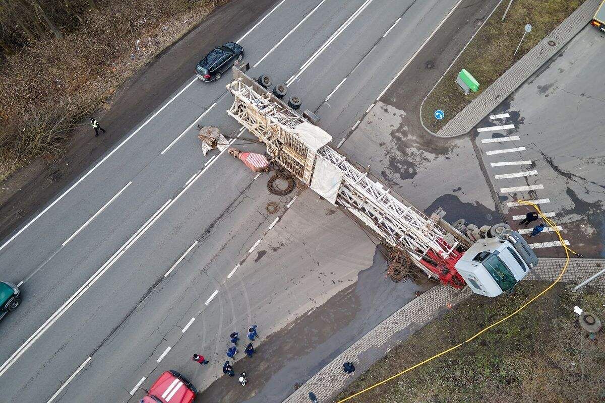
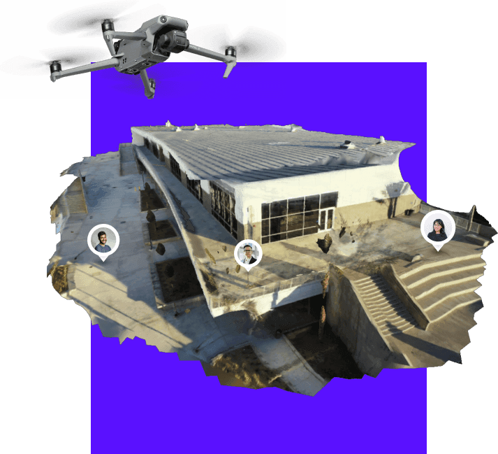
Large loss efficiency: Commercial property losses spanning 40,000+ SF overwhelm manual documentation. Video-based capture completes in hours rather than days — walk or fly the structure, upload footage, receive measurement-ready models. Adjusters advance files while documentation processes rather than waiting days to complete fieldwork.

What is the ROI of upgrading adjuster documentation tools?
For adjusting operations processing 500 annual claims, video-based documentation generates approximately $75K-$125K in annual savings through reduced labor costs ($30K-$50K from eliminated site revisits), faster settlement velocity ($25K-$40K from improved portfolio turnover), and supplement prevention ($20K-$35K from avoided rework). ROI justifies technology investment within the first year of deployment.
Traditional property adjusting requires 2-3 site visits averaging 3-4 hours total field time per claim. Comprehensive video-based documentation compresses this to single 45-minute visits. The cycle time reduction accelerates claim closure by 7-10 days on average while reducing supplement frequency by 40-50% through first-visit documentation completeness.
Litigation preparation provides additional ROI. Claims proceeding to litigation or appraisal require documentation surviving expert witness challenge. A 3D model with verified measurements provides spatial evidence that photos and manual notes cannot match — shifting litigation dynamics from competing narratives to documented facts and reducing defense costs.
What equipment do adjusters need by claim type?
Residential roof claims require a drone or elevated capture device plus smartphone for interior documentation. Commercial large-loss claims require drone coverage of the full facility envelope plus systematic interior walkthroughs. Casualty and liability claims require comprehensive scene documentation with measurement capability for premises liability and accident reconstruction cases.
| Claim Type | Capture Method | Recommended Tools |
|---|---|---|
| Residential roof | Drone orbit or elevated smartphone video | Consumer drone (DJI Mini series) + SkyeBrowse |
| Residential interior | Smartphone walkthrough video | iPhone/Android + SkyeBrowse Universal Upload |
| Commercial property | Drone aerial + interior walkthrough | Enterprise drone + smartphone + SkyeBrowse |
| Hail/wind catastrophe | Rapid drone deployment at scale | Fleet drones + cloud processing for volume |
| Casualty/liability | Scene documentation with measurements | Any video source + SkyeBrowse Premium |
All capture devices must comply with FAA Part 107 requirements when drones are used commercially. SkyeBrowse's Universal Upload accepts .MP4 and .MOV from any source — drones, smartphones, body cameras, and action cameras — eliminating hardware lock-in.
How does SkyeBrowse fit into adjuster workflows?
SkyeBrowse is a videogrammetry platform that processes video into measurable 3D models and 2D maps on AWS GovCloud infrastructure. For insurance workflows, it accepts any smartphone or drone video, processes at approximately 1:1 speed (6-minute capture returns a model in 6 minutes), and exports in formats compatible with Xactimate and standard estimating platforms. Premium tiers include 5-year storage, chain-of-custody logging, and CJIS-focused access controls.
Three accuracy tiers serve different insurance use cases: Lite for catastrophe triage, Premium ($99/credit, 0.25 inch accuracy at 8K) for standard property claims, and Premium Advanced ($199/credit, 0.1 inch accuracy at 16K) for disputed claims and fraud investigations.
For a deeper look at how videogrammetry supports the full claims lifecycle, see the insurance claims documentation guide.