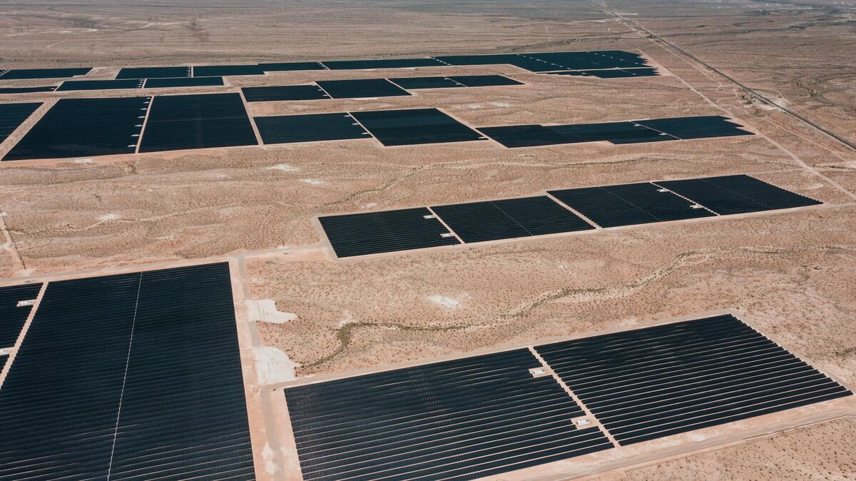
Airport operations teams face a persistent tension: airfields must stay open to generate revenue, yet runways and taxiways require regular condition surveys, obstruction assessments, and compliance documentation. Airport drone mapping — the practice of flying systematic UAV surveys and converting the video into georeferenced 3D models and orthomosaics — compresses what used to be multi-day closure events into 30–60 minute windows. SkyeBrowse is a cloud-based videogrammetry platform (video-to-3D and 2D mapping) used by public safety and infrastructure teams to generate measurable spatial records from drone video in near real time.
Key Takeaways
- A drone runway survey requiring a 30–60 minute controlled closure replaces 2–3 day ground survey operations that cost $15,000–$30,000 per assessment.
- SkyeBrowse's Premium tier delivers approximately 0.25-inch accuracy at 8K resolution — sufficient for pavement condition index scoring and crack severity classification.
- GeoTIFF orthomosaics and LAZ point clouds export directly into airport pavement management systems like PAVER and APMS, fitting existing workflows.
- AWS GovCloud hosting with 5-year model retention on premium tiers supports FAA Airport Certification Manual documentation requirements and federal audit readiness.
- A task that once required a four-person ground crew for several hours can be completed by a single drone operator in under 15 minutes of flight time.
Contents
- Why are traditional airfield surveys so disruptive to flight operations?
- How does drone mapping reduce runway closure time?
- What can airport engineers measure from a drone-generated airfield model?
- How does drone mapping support FAA compliance and federal funding documentation?
- What other airport operations benefit from aerial drone mapping?
- FAQ
Why are traditional airfield surveys so disruptive to flight operations?
Conventional runway condition surveys use GPS rovers, crack sealing crews, or photographic walkovers that require the pavement surface to be clear of aircraft for 2–3 days at a time. At busy airports, each closure triggers flight diversions, landing fee losses, and airline penalties that push total impact well above the direct survey cost — often exceeding $100,000 for a comprehensive assessment at a high-traffic airport.
The FAA's Advisory Circular 150/5380-6G establishes guidelines for airport pavement maintenance programs, and the agency expects regular pavement condition index (PCI) assessments to sustain Airport Improvement Program eligibility. That regulatory pressure makes survey frequency non-negotiable, but the operational cost of each closure creates a real incentive to delay. Pavement deterioration that goes undetected between infrequent surveys accelerates faster than planned, pushing airports into reactive emergency repairs rather than cost-efficient preventive maintenance cycles.
The fundamental problem is instrument design: ground-based survey equipment is built for precision, not speed, and it physically occupies the surface being measured. Drone-based mapping decouples those requirements. The drone operates above the runway, the closure window covers only the flight time, and processing happens remotely while operations resume. The output is a spatially verified record available the same day — not a report delivered weeks later.
How does drone mapping reduce runway closure time?
Drone mapping compresses a complete runway survey into 30–60 minutes of controlled closure. The operator flies systematic lapping passes above the pavement during a coordinated quiet window, then the cloud platform processes the video into a georeferenced model automatically while the runway reopens for traffic. Airport engineering staff review measured outputs the same day rather than waiting for traditional survey deliverables.
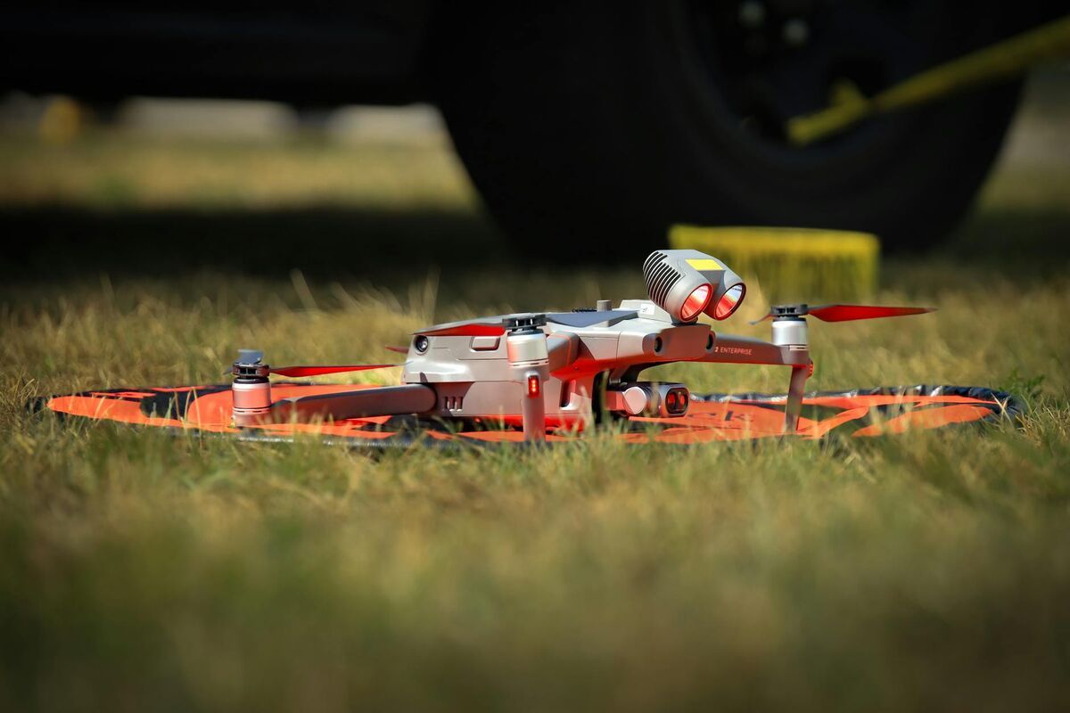
SkyeBrowse accepts .MP4 and .MOV video from any GPS-enabled drone. For airfield surveys, operators upload directly through the web platform at app.skyebrowse.com or sync telemetry files — .SRT for DJI systems, .ASS for Autel — to improve georeferencing accuracy without additional ground control points. The platform's processing speed scales roughly with flight duration, so a 12-minute runway video returns a navigable 3D model in approximately the same window. Airport staff begin reviewing pavement conditions while the next aircraft is already on approach.
For multi-runway airports, teams capture each operational surface in separate sessions timed to staggered low-traffic windows. Because no desktop software installation or dedicated processing hardware is required, results from the first runway are available before the second survey even starts. That sequencing allows a full airfield documentation cycle to complete within a single operational day rather than across multiple days of staggered closures.
The practical cost differential is significant. Direct drone survey costs run under $200 per model in processing credits. Compared to $15,000–$30,000 for traditional ground surveys — plus diversion costs — the economics favor frequent drone surveys and early-stage intervention over infrequent comprehensive assessments.

What can airport engineers measure from a drone-generated airfield model?
Engineers can measure crack width, pavement distress extent, surface elevation changes, runway safety area dimensions, and obstruction clearances directly from the 3D model and orthomosaic. The Premium tier's 8K resolution supports standard PCI distress classification; the Premium Advanced tier's 16K resolution and 0.1-inch accuracy support FAA Part 77 obstruction surveys and regulatory submissions.
SkyeBrowse's accuracy tiers are matched to task severity. For routine pavement condition programs, the Premium tier (approximately 0.25-inch horizontal accuracy at 8K resolution) supports the distress severity thresholds defined in ASTM D5340, the standard method for airport pavement condition index surveys. Engineers classify alligator cracking, rutting, raveling, and other distress types at a level of detail that grounds capital planning decisions.
The Premium Advanced tier (0.1-inch accuracy at 16K resolution) adds AI-assisted moving object removal for cleaner point clouds and supports applications requiring survey-grade positioning: Part 77 obstruction surveys, runway safety area (RSA) grading verification, and obstruction mitigation design. Those outputs meet the spatial precision threshold for regulatory submissions without ground survey verification for most documentation contexts.
Exports fit existing airport data ecosystems. The GeoTIFF orthomosaic overlays directly onto airport GIS platforms and ESRI-based airfield management systems. The LAZ point cloud imports into pavement management software including PAVER and the Airport Pavement Management System (APMS), where automated distress detection algorithms further accelerate condition scoring. Engineers calculate remaining service life and optimize rehabilitation schedules using verified spatial data rather than visual estimates.
Compared to LiDAR-based capture, drone video mapping covers large airfield areas faster and at lower cost. For most pavement condition and FAA compliance applications, the accuracy tiers available through videogrammetry are sufficient. LiDAR vs. photogrammetry tradeoffs are worth reviewing when sub-centimeter vertical accuracy or dense vegetation penetration becomes a requirement.
How does drone mapping support FAA compliance and federal funding documentation?
Airport models stored in AWS GovCloud with 5-year guaranteed retention on premium tiers provide the archived temporal record that FAA Airport Certification Manual documentation programs require. Georeferenced outputs with audit trails — showing who accessed data and when — demonstrate operational diligence during FAA inspections and support federal grant applications with objective condition evidence.
The FAA's Airport Improvement Program (AIP) and Passenger Facility Charge (PFC) funding mechanisms both require documented pavement condition programs. Grant applications supported by objective GeoTIFF orthomosaics and quantified PCI scores carry more weight than subjective written assessments. When federal engineers review project justifications, spatially referenced models with measurable distress data replace the ambiguity of photographic narratives.
For Part 139 airport certification, FAA inspectors verify that airports maintain documented safety programs covering pavement condition, wildlife hazard management, and runway safety areas. SkyeBrowse's cloud storage creates a timestamped archive of condition snapshots that satisfies historical monitoring requirements. When an inspector asks how pavement condition at a specific threshold has changed over the past 18 months, the answer can come from retrievable georeferenced models rather than written logs.
Incident documentation benefits from the same infrastructure. When FOD (Foreign Object Debris) events cause aircraft damage or pavement failures trigger airworthiness concerns, a same-day drone survey generates the spatial evidence needed for insurance claims, contractor liability documentation, and internal safety reviews. The model is shareable as a browser link, avoiding the need to transfer large files to investigators.
The drone surveying guide covers georeferencing methods and accuracy expectations across different application types, which is useful context for airport engineers evaluating what accuracy tier to specify for a given compliance use case.
What other airport operations benefit from aerial drone mapping?
Wildlife hazard management, snow removal planning, master planning, and pre-construction condition documentation all benefit from drone-generated airfield models. The orthomosaic and 3D geometry available from a single survey flight serve multiple departments without repeated closures.
Wildlife hazard assessments required under FAA Advisory Circular 150/5200-36B involve identifying vegetation encroachment, standing water, and habitat features that attract wildlife near runways. An orthomosaic from a recent airfield survey locates these features faster than ground walkovers and supports the spatial analysis required for Wildlife Hazard Management Plans.
Winter operations planning uses airfield geometry to optimize snow removal staging and plow route sequencing. Post-storm assessments that would otherwise require manual inspection of each pavement surface can be captured aerially in one coordinated flight.
Airport master planning projects depend on accurate as-built documentation of existing conditions. Models are immediately usable in CAD and GIS environments, giving engineers evaluating taxiway modifications or runway extension feasibility current spatial data rather than aging drawings.
The disaster response mapping workflow used by public safety agencies applies directly to airport storm damage assessment. For teams building out drone mapping programs, the drone mapping software guide covers platform selection and accuracy benchmarking relevant to airport operational environments.

FAQ
Do airports need FAA authorization to fly drones for runway surveys?
Yes. Runways and taxiways are located within controlled airspace, and all drone operations require coordination with the airport authority and air traffic control. Airport operators typically schedule surveys during pre-arranged low-traffic windows and must operate under Part 107 rules plus any airport-specific operating procedures. Many airports have established internal UAS programs specifically for this purpose.
What accuracy can airport engineers expect from drone mapping?
SkyeBrowse's Premium tier delivers approximately 0.25-inch horizontal accuracy at 8K resolution, which supports standard pavement condition index assessments and distress severity classification. The Premium Advanced tier reaches 0.1-inch accuracy at 16K resolution for applications requiring survey-grade positioning, such as Part 77 obstruction surveys and RSA grading verification. For applications where sub-centimeter vertical accuracy is critical, supplementing with ground control points or LiDAR is worth evaluating.
How long does a drone runway survey take compared to a traditional ground survey?
A single-runway drone survey typically requires a 30–60 minute controlled closure window for flight, with processing completing in approximately the same time frame while the runway reopens. Traditional ground surveys with GPS rovers and crack-logging crews require 2–3 day closures and professional survey teams, often running $15,000–$30,000 per assessment before accounting for flight diversion costs.
Can drone mapping outputs integrate with airport pavement management systems?
Yes. SkyeBrowse exports GeoTIFF orthomosaics and LAZ point cloud files that load directly into pavement management platforms such as PAVER and APMS. Airport GIS systems accept the georeferenced outputs for overlay with existing airfield data, historical condition tracking, and capital planning workflows.