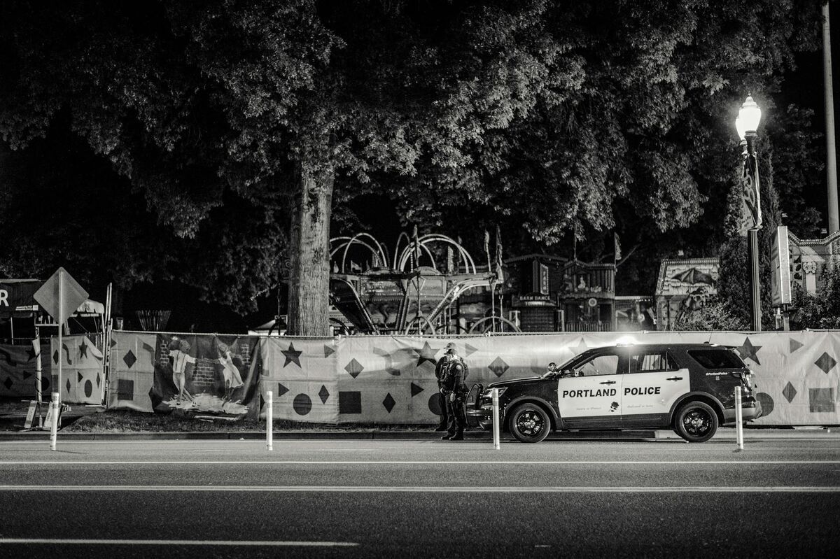
DFR — Drone as First Responder — is a public safety program that stations drones at fixed launch points and integrates them with Computer-Aided Dispatch (CAD) so an unmanned aircraft deploys automatically when a qualifying call comes in. The DFR drone reaches the scene and begins transmitting live video before any police, fire, or EMS ground unit arrives, giving commanders real-time situational awareness in 60 to 120 seconds.
DFR programs have grown rapidly among public safety agencies that need eyes on a situation in seconds, not minutes. This guide explains how DFR programs are structured, what FAA authorizations they require, which hardware agencies choose, and how 3D documentation software turns that drone footage into lasting spatial evidence.

Key Takeaways
- DFR programs can put a drone over a scene in under 90 seconds — faster than the first ground unit can reach most calls.
- Operating a DFR drone beyond the operator's line of sight requires an FAA BVLOS waiver, issued through the DroneZone portal after a risk mitigation review.
- AUVSI reports that over 1,500 public safety agencies in the United States had active drone programs as of 2024, with DFR deployments among the fastest-growing use cases.
- After the live response phase, the same DFR video can be processed through a videogrammetry platform to produce a court-ready 3D model, orthomosaic, and exportable point cloud.
- SkyeBrowse's cloud-based videogrammetry pipeline — hosted on FedRAMP Moderate authorized AWS GovCloud infrastructure — lets investigators generate a spatially accurate model from incident footage without any dedicated processing hardware.
Contents
- What does DFR stand for?
- How DFR programs differ from traditional drone units
- What FAA authorizations do DFR programs require?
- What hardware do DFR programs use?
- How do agencies integrate 3D mapping into DFR operations?
- What are the operational benefits of a DFR program?
- FAQ
What does DFR stand for?
DFR stands for Drone as First Responder. The term describes a specific operational model — not just any agency that owns drones — where an unmanned aerial vehicle is dispatched to an incident as the literal first resource on scene, ahead of all human responders.
The concept originated with the Chula Vista Police Department (CVPD) in California, which launched one of the earliest and most studied DFR programs in 2018. CVPD's program, operated in coordination with the FAA under a BVLOS waiver, demonstrated that a drone could be overhead within 90 seconds of a 911 call for incidents within a one-mile radius of a launch dock. The program became a national reference model: agencies from Raleigh, NC to Honolulu, HI have since built DFR operations using CVPD's published data and FAA waiver framework as a starting point.
The Association for Uncrewed Vehicle Systems International (AUVSI) has tracked the expansion of DFR programs and documented measurable improvements in officer safety and use-of-force rates at agencies that adopted the model. Today, DFR is a recognized program category in public safety aviation, distinct from patrol drone units, tactical drone teams, or search-and-rescue aviation assets.
How DFR programs differ from traditional drone units
A traditional police or fire drone unit deploys pilots and aircraft on a per-request basis — a sergeant calls for drone support, a pilot drives to the scene, and the drone lifts off minutes or hours after the incident began. A DFR program eliminates those delays by pre-positioning drones at fixed docks connected directly to CAD, so the aircraft launches within seconds of call receipt — autonomously, without waiting for a human pilot to arrive.
The operational gap between a traditional drone unit and a DFR program is larger than it appears on paper:
Dispatch model. Traditional units require a human decision to activate and a pilot to physically respond. DFR programs automate launch through CAD integration — when a qualifying call type comes in, the dock releases the aircraft without manual intervention.
Response time. A traditional drone unit might arrive on scene 10 to 30 minutes after an incident starts. A well-sited DFR dock delivers the aircraft in under two minutes for calls within operational range. That difference determines whether the drone documents a fluid, developing incident or arrives after ground units have already resolved it.
Infrastructure requirements. DFR programs require fixed launch infrastructure — weatherproof docks with automated charging, cellular or RF command-and-control links, and CAD integration software. Traditional programs need only a vehicle and a case. The upfront investment in DFR infrastructure is higher, but the cost-per-deployment drops sharply at volume compared to staffed helicopter or patrol aviation programs.
Regulatory posture. DFR operations almost always require a BVLOS waiver or public aircraft COA because the aircraft operates beyond the visual range of any single operator from launch through patrol. Traditional drone programs typically stay within Part 107 visual line-of-sight limits and need no waiver for standard patrol missions.
Well-known DFR programs in the United States beyond Chula Vista include the Las Vegas Metropolitan Police Department, the Raleigh Police Department (which operates multiple docks across the city), and an expanding number of fire departments that use DFR assets for structure fire size-up and hazmat scene assessment before crews make entry.
What FAA authorizations do DFR programs require?
Most DFR deployments require a Beyond Visual Line of Sight (BVLOS) waiver under 14 CFR Part 107. The FAA issues these waivers through the DroneZone portal after the applicant demonstrates a safety case covering detect-and-avoid capability, communication redundancy, lost-link procedures, and coordination with local air traffic. Government agencies operating publicly-owned aircraft may also qualify for a Certificate of Waiver or Authorization (COA) under the public aircraft operator framework.
The FAA's UAS integration program distinguishes between three authorization paths relevant to DFR operations. First, a standard Part 107 certificate covers visual-line-of-sight operations where the remote pilot keeps the drone in unaided view. Second, a Part 107 waiver for BVLOS permits operations beyond that range when the FAA accepts the safety case. Third, a COA covers public aircraft operations — government-owned drones flown by government employees on official duties — which can offer a faster path for law enforcement and fire agencies.
Agencies pursuing BVLOS waivers typically must demonstrate a communications architecture (usually LTE or dedicated RF with a fallback link), a lost-link return-to-home procedure, and coordination agreements with any airport within the flight corridor. The NIST Public Safety Communications Research program has published technical benchmarks for LTE-based command-and-control links used in public safety DFR programs that serve as useful reference points during waiver applications.
Remote ID compliance — broadcasting the drone's identity and position — is also required for all DFR aircraft registered after September 2023, with no law enforcement exemption for the broadcast requirement itself.
What hardware do DFR programs use?
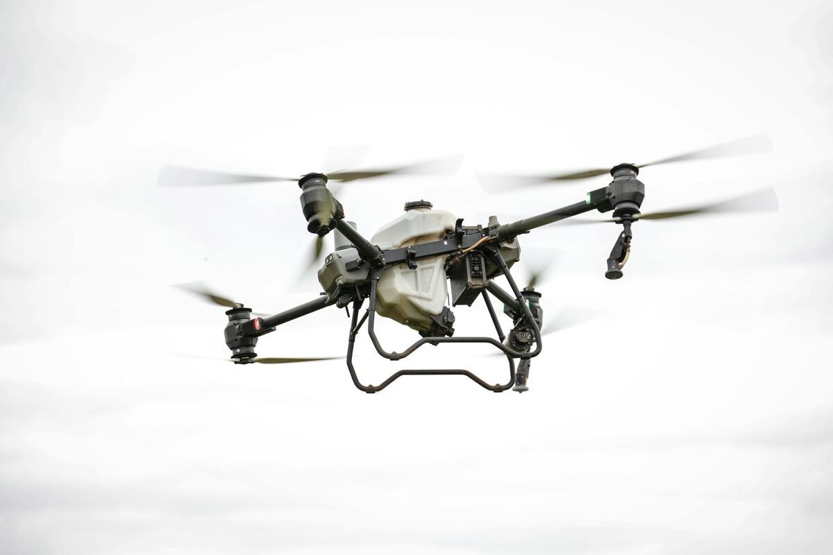
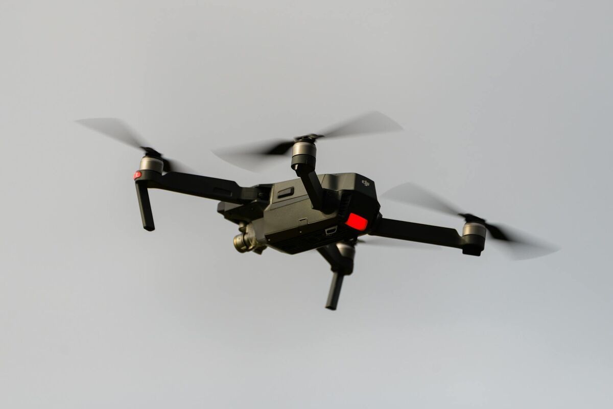
DFR programs favor aircraft that combine reliable autonomous flight, extended loiter time, and broadcast-quality video — typically enterprise-class drones with dedicated docking and charging infrastructure. Popular platforms include the DJI Dock series, Percepto Arc, Skydio X10 Dock, and Autel Robotics Alpha. Agencies select hardware based on wind tolerance, camera sensor options (EO, thermal, or multi-sensor), battery cycle counts, and whether the manufacturer offers a BVLOS-compatible detect-and-avoid solution.
Hardware selection for a DFR program involves trade-offs that differ from a patrol program. Range matters less than reliability and launch latency — the aircraft needs to be airborne in under 30 seconds of call receipt. Thermal imaging capability is often required for nighttime calls and structure fires. The DJI Dock 2, for instance, supports automated pre-flight checks, environmental heating in cold climates, and integration with third-party CAD systems via API.
SkyeBrowse supports a wide range of enterprise drones commonly deployed in DFR operations, including DJI Matrice, DJI Air, and Autel platforms. The platform accepts standard .MP4 and .MOV video, and DJI .SRT telemetry files improve georeferencing accuracy of the resulting models. For departments that already operate fire department drone operations and want to add DFR capability, the same aircraft fleet can often serve both missions.
How do agencies integrate 3D mapping into DFR operations?
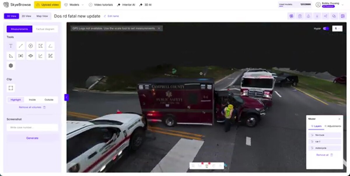
The DFR drone's live video feed serves the response phase — command staff watch in real time and deploy resources accordingly. After the incident stabilizes, investigators upload that same footage to a videogrammetry platform, which reconstructs the scene geometry from video frames to produce a 3D model, orthomosaic map, and georeferenced point cloud. This post-incident documentation layer preserves spatial evidence that would otherwise exist only as video playback.
Videogrammetry — the discipline of extracting 3D measurements and geometry from video sequences — is the bridge between a DFR program's live feed and its long-term evidence value. SkyeBrowse's cloud-based videogrammetry pipeline lets investigators upload the .MP4 captured during the DFR response directly to app.skyebrowse.com. No specialized workstation is required; processing runs on AWS GovCloud infrastructure and returns an interactive model within minutes.
For a traffic crash or hit-and-run, investigators can use the DFR footage — recorded from the moment of dispatch, often before any vehicle has moved — to generate a pre-disturbance scene model. That model supports accident reconstruction analysis with measurements accurate to approximately 0.25 inch on Premium tier processing and approximately 0.1 inch with Premium Advanced 16K modeling.
Drone 3D mapping during DFR operations also shortens the scene closure window. When investigators can document a crash or crime scene spatially in minutes rather than hours, roads reopen faster and community impact is reduced. Departments that have integrated this workflow report cutting scene documentation time from two to four hours down to under thirty minutes.
For search and rescue deployments, DFR footage processed through SkyeBrowse creates a georeferenced terrain model that search coordinators can use to assign search sectors, track coverage, and debrief teams — capabilities that require accurate spatial data rather than raw video.
What are the operational benefits of a DFR program?
DFR programs deliver three core operational benefits: faster situational awareness before ground units arrive, reduced risk to officers who would otherwise approach an unknown scene blind, and a continuous aerial record that supports post-incident investigation and use-of-force review. Secondary benefits include reduced scene closure time, improved dispatcher accuracy, and lower total cost per incident compared to helicopter deployment.
Speed is the headline benefit. A well-positioned DFR dock can put an aircraft over a scene in under 90 seconds for calls within a one-mile radius — typically two to four minutes faster than the first patrol unit. That time advantage changes the operational calculus for high-risk calls such as active shooters, domestic violence incidents with weapons, and vehicle pursuits.
Officer safety improvements are measurable. When officers arrive at a scene where a DFR drone has already transmitted the suspect's location, number of individuals present, and whether weapons are visible, they can approach with a tactical plan rather than reacting to unknowns. Departments with mature DFR programs have documented reductions in use-of-force incidents because officers are better informed before any physical encounter.
From a documentation standpoint, the combination of a DFR program and a CJIS-compliant mapping platform closes the evidence gap between real-time response and legal proceedings. SkyeBrowse's CJIS-focused workflows on premium tiers ensure that cloud-processed 3D models meet the access control, audit logging, and data handling requirements that courts and prosecutors expect. Exports in LAZ (point cloud), GLB (3D mesh), and GeoTIFF (orthomosaic) formats integrate with case management systems used by district attorneys and forensic engineering firms.
The cost comparison with air support units is equally compelling. A helicopter hour typically costs $800 to $1,500, including crew and maintenance. A DFR dock deployment costs a fraction of that per call while offering faster response for incidents within operational range.

FAQ
What does DFR stand for?
DFR stands for Drone as First Responder. A DFR program dispatches an unmanned aircraft autonomously to an incident so it arrives and begins transmitting live video before any police, fire, or EMS ground unit reaches the scene. Chula Vista PD's program, launched in 2018, is the most widely cited early DFR deployment and remains an active reference model for agencies building new programs.
Does a DFR program need FAA approval?
Yes. DFR operations almost always exceed visual line of sight, which requires a Part 107 BVLOS waiver from the FAA. Government agencies operating publicly-owned drones may also qualify for a Certificate of Waiver or Authorization (COA) under the public aircraft operator framework, which some departments find faster to obtain. The FAA UAS portal provides current waiver application guidance and status updates on the broader BVLOS rulemaking effort.
How does SkyeBrowse work with a DFR program?
After the live response phase ends, investigators upload the DFR drone footage to app.skyebrowse.com. The platform's videogrammetry engine reconstructs scene geometry from the video frames and returns an interactive 3D model, orthomosaic, and point cloud — typically within minutes, on cloud infrastructure, with no desktop processing hardware required. Models can be shared via link with prosecutors, investigators, or insurance adjusters, and exported in standard formats for CAD and GIS integration. See skyebrowse.com/pricing-premium for per-model and enterprise licensing options.
What accuracy does SkyeBrowse achieve from DFR drone video?
Processing tier determines accuracy. The Lite tier produces models accurate to approximately 2 to 6 inches — sufficient for scene orientation and overview. Premium tier (8K resolution) achieves approximately 0.25 inch accuracy, and Premium Advanced (16K with AI moving-object removal) reaches approximately 0.1 inch — suitable for forensic measurement and court presentation.