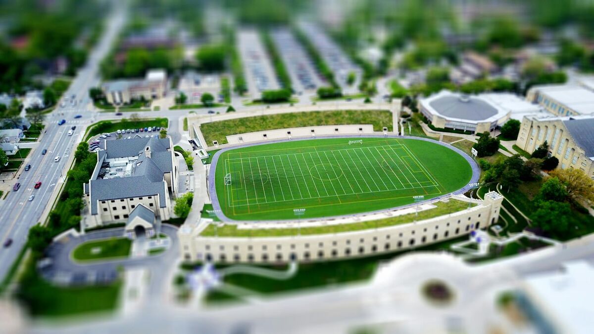
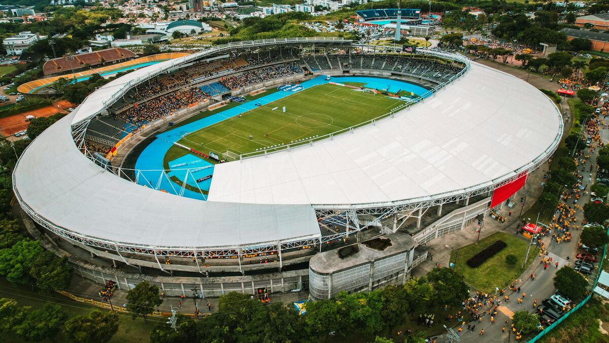
Effective event security planning depends on spatial intelligence: accurate layouts, sight line data, evacuation route widths, and coverage gap analysis — all needed before a single attendee arrives. Videogrammetry (the process of converting video footage into accurate 3D models) gives security coordinators a way to build navigable venue maps from drone or walkthrough video in under an hour, without waiting weeks for CAD files or relying on outdated floor plans. SkyeBrowse brings this workflow to public safety and private security teams managing concerts, festivals, sporting events, and large-scale public gatherings.
Key Takeaways
- A single drone operator can capture a venue perimeter and deliver a navigable 3D model to the security team in under 45 minutes — faster than a manual site walk by a four-person team.
- Videogrammetry captures spatial relationships that floor plans miss: actual fencing configurations, barricade positions, temporary structure heights, and blind spot geometry.
- SkyeBrowse accepts video from drones, smartphones, and 360 cameras, making it practical for both aerial perimeter surveys and interior corridor mapping where drone flight is restricted.
- Premium tier accuracy (approximately 0.25 inch at 8K) is sufficient for camera field-of-view analysis and evacuation corridor measurement; Premium Advanced (0.1 inch at 16K) supports post-incident forensic reconstruction.
- Venue models stored on AWS GovCloud with FedRAMP Moderate Authorization can be shared securely across multi-agency teams — local police, fire marshals, and private security — without emailing large files.
Contents
- Why do event security teams need 3D venue maps?
- How does event drone mapping work in practice?
- How does a 3D model improve camera placement and sight line analysis?
- How does drone mapping support multi-agency coordination?
- How does venue documentation protect organizers after an incident?
- FAQ
Why do event security teams need 3D venue maps?
Traditional event security planning tools — architectural drawings, static photographs, and manual site walks — capture a venue at a moment in time and rarely reflect the temporary structures, fencing configurations, and vendor placements installed for a specific event. A navigable 3D model built from the as-configured venue captures the operational reality that security teams will actually face on event day, including the blind spots, egress bottlenecks, and sight line restrictions created by temporary infrastructure.
The gap between an architect's floor plan and an event-day venue can be significant. Stage risers narrow corridors. Vendor booths block camera sight lines. Temporary fencing redirects crowd flow in ways that weren't modeled during initial planning. When security coordinators brief response teams using outdated documentation, they create coverage plans that don't match conditions on the ground.
The Department of Homeland Security's Special Events Planning Guide recommends thorough venue assessment as a foundational step in special event security planning — documenting access and egress points, surveillance coverage zones, and emergency response staging areas. Completing that assessment against the actual event configuration, rather than last year's generic floor plan, is exactly what videogrammetry enables.
For touring productions, this gap compounds. Building a model library for each tour stop — captured by local staff using standard drone hardware — gives traveling security teams actual geometry rather than verbal descriptions, and it survives the contractor turnover common in touring production.
How does event drone mapping work in practice?
An operator flies a standard orbital or grid pattern around the venue perimeter while recording video with a DJI or compatible drone. The video file is uploaded to SkyeBrowse's cloud platform, which processes it into a navigable 3D model at approximately a 1:1 time ratio — a 15-minute capture produces a model in roughly 15 minutes. No desktop processing hardware is required; the model is accessible from any browser-connected device as soon as processing completes.
The workflow requires no specialized survey training. A single operator captures a stadium exterior, festival grounds, or convention center campus during setup — when structures are in place but crowds are absent. The SkyeBrowse Flight App provides automated flight path guidance, and telemetry files from DJI drones (.SRT format) improve georeferencing accuracy without ground control points.
Most venues restrict drone flight indoors. SkyeBrowse handles this through Universal Upload, which accepts video from smartphones, 360 cameras, or action cameras. A coordinator walking concourse levels and service tunnels while recording generates footage that processes through the same cloud platform, producing interior models that show corridor widths, exit positions, and crowd staging geometry.
For complex venues — multi-level amphitheaters, fairgrounds with multiple stages — combining aerial drone captures with interior walkthrough video produces a complete picture that supports the egress documentation requirements in NFPA 101: Life Safety Code, which governs exit widths, travel distances, and assembly area capacities.

How does a 3D model improve camera placement and sight line analysis?
A navigable 3D model lets security planners virtually walk the venue, rotate to any angle, and measure actual distances between camera positions and coverage targets. Unlike a 2D floor plan, the 3D geometry captures the elevation changes, structural obstructions, and temporary infrastructure that determine whether a camera can actually see a zone — before any equipment is mounted.
SkyeBrowse Premium delivers 8K resolution at approximately 0.25-inch accuracy — enough to measure sight line distances from proposed camera mounts, identify obstructions that will block wide-angle lenses, and calculate overlap between adjacent camera fields of view. The GLB mesh export opens in standard 3D visualization tools used by security technology integrators.
For events requiring forensic-quality documentation — VIP protection, dignitary visits, counterterrorism protocols — Premium Advanced produces 16K resolution models with 0.1-inch accuracy and AI-assisted moving object removal. A coverage planning workflow that previously required a consultant spending 4–8 hours on-site with a laser rangefinder now runs from a browser, before booking a flight to the venue city.
The same principle that search and rescue teams apply to aerial situational intelligence holds for event security: accurate spatial data, delivered fast, changes operational decisions. For more on how public safety agencies use drone mapping for rapid site assessment, see the search and rescue drone mapping guide and the drone disaster response mapping overview.
How does drone mapping support multi-agency coordination?
Large events routinely involve venue security, local law enforcement, fire marshals, emergency medical services, and sometimes federal agencies operating from a shared incident command structure. SkyeBrowse's controlled sharing model lets all response partners access the venue model through secure browser links with configurable permissions — without exchanging large files by email or requiring every agency to install software.
When the shared spatial reference is a 3D model rather than a static PDF, briefings change. Incident commanders can orient responders to specific zones by navigating the model live. Local law enforcement unfamiliar with the venue can review it before arriving on-site. Fire marshals can verify that evacuation routes match fire plan documentation without a separate site visit.
For recurring events at the same venue, the model becomes a long-term planning asset — updated after major venue renovations and stored in a model library that survives personnel turnover and contract transitions. Post-event debriefs improve when security leadership reviews the 3D model alongside incident reports to identify coverage gaps and staging area inefficiencies visible in the spatial record.
The tactical planning software guide covers how agencies evaluate tools for shared operational planning, including spatial documentation requirements that directly overlap with event security needs.
How does venue documentation protect organizers after an incident?
When event-related injuries, security breaches, or crowd incidents result in litigation, the quality of pre-event documentation determines what evidence is available for defense or liability assessment. A 3D model of the venue as configured for the specific event — showing exit placement, security post positions, barricade configurations, and camera coverage zones — provides verifiable spatial evidence that verbal security plans and generic floor plans cannot match.
SkyeBrowse stores venue models on AWS GovCloud (US) infrastructure with FedRAMP Moderate Authorization. Premium tier storage includes 5-year guaranteed retention, covering the statute of limitations window for most event-related liability claims. Audit trails document who accessed the venue model and when — a chain-of-custody record that matters in legal discovery.
Insurance underwriters increasingly credit objective pre-event documentation. A venue operator who can show that security deployment was planned against an accurate 3D model — with measurable coverage zones and a verifiable record of the as-built event configuration — presents a lower risk profile than one relying on undocumented manual planning.
For incidents requiring criminal investigation, the venue model gives investigators spatial context to reconstruct timelines: suspect movement paths, security response routes, and bystander positions analyzed against fixed geometry. The forensic engineering guide covers the evidentiary standards these models must meet. The economics are straightforward: what once took a four-person team 3 hours now takes a single operator roughly 10 minutes — dropping labor cost from approximately $360 to $25 while producing a verifiable 3D record on the same day.

FAQ
How long does it take to build a 3D venue model for event security planning?
Capture takes 10–20 minutes by a single operator. SkyeBrowse processes video at roughly a 1:1 ratio, so a 15-minute capture returns a navigable model in about 15 minutes. Total turnaround from landing to a reviewable model is under 45 minutes — fast enough to complete a venue survey during load-in and have a planning model ready before the production meeting ends.
Can SkyeBrowse be used for indoor venue mapping like arenas and convention centers?
Yes. SkyeBrowse accepts video from smartphones, 360 cameras, and action cameras in addition to drones — practical for interior corridors and staging areas where drone flight is restricted. Interior walkthrough video is uploaded through the same Universal Upload interface at app.skyebrowse.com and produces navigable 3D models showing corridor widths, exit positions, and crowd staging geometry.
Is venue 3D mapping data secure enough for law enforcement event security teams?
SkyeBrowse stores data on AWS GovCloud (US) infrastructure and holds FedRAMP Moderate Authorization. Premium tiers support CJIS-focused access controls with audit trails and controlled sharing — meeting the documentation and chain-of-custody standards required by most law enforcement agencies managing large-event operations. Agencies with specific compliance requirements can review SkyeBrowse's CJIS-compliant mapping capabilities for a full breakdown of security tier options.
What accuracy level do event security planners need for camera placement analysis?
For camera coverage planning, SkyeBrowse Premium delivers 8K resolution at approximately 0.25-inch accuracy — sufficient to measure field-of-view corridors and identify coverage gaps. For post-incident forensic reconstruction, Premium Advanced provides 16K resolution at 0.1-inch accuracy with AI moving object removal, producing models suitable for criminal investigation and litigation support.