Forensic engineering — the scientific investigation of failures, accidents, and structural collapses to establish cause and origin — has historically depended on time-intensive ground surveys, tape measures, and total stations. Drone videogrammetry, the process of deriving precise 3D measurements from drone video footage, is changing that. SkyeBrowse processes raw drone video into georeferenced 3D models and 2D orthomosaics in minutes, giving forensic engineers a complete, court-ready scene record before road lanes reopen or weather destroys evidence. This article explains how drone-based forensic engineering works across crash reconstruction, structural failure analysis, and fire origin investigation.
Key Takeaways
- Drone videogrammetry cuts forensic scene documentation from hours to under 30 minutes
- SkyeBrowse produces court-ready 3D models, orthomosaics, and point clouds from a single drone flight
- Premium Advanced accuracy (0.1 inch) meets requirements for expert testimony and litigation support
- Applicable to crash reconstruction, structural failure analysis, and fire origin investigation
Contents
- What does forensic engineering involve?
- How does drone videogrammetry accelerate forensic documentation?
- How is drone mapping used in crash and accident reconstruction?
- Can drones support structural failure and fire origin investigations?
- What outputs does SkyeBrowse deliver for forensic engineering cases?
- FAQ
What does forensic engineering involve?
Forensic engineering is the systematic investigation of structures, vehicles, materials, and scenes to determine why a failure or accident occurred. It produces documented findings used in litigation, insurance claims, regulatory review, and safety improvement. Common assignments include vehicle crash reconstruction, building collapse analysis, fire origin and cause determination, and product liability investigations.
The National Institute of Standards and Technology's disaster and failure studies program and the NTSB's accident investigation process both underscore the same requirement: physical evidence must be captured quickly, completely, and in a format that withstands adversarial scrutiny. Traditional methods — manual measurements, ground photographs, hand-drawn sketches — are slow, subject to observer error, and hard to share with remote experts. The richer and more spatially accurate the initial scene record, the more defensible each downstream analysis becomes.
How does drone videogrammetry accelerate forensic documentation?
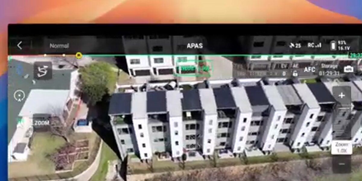
Drone videogrammetry uses overlapping frames extracted from drone video to reconstruct the three-dimensional geometry of a scene through photogrammetry algorithms. SkyeBrowse automates this pipeline: an operator flies a standard orbit or grid pattern over the scene, uploads the .MP4 or .MOV footage to app.skyebrowse.com, and receives a georeferenced 3D model and orthomosaic map typically within ten to thirty minutes — no desktop processing hardware required.
The speed advantage is decisive in forensic work. A major highway accident scene may block traffic for four to six hours; a fire-damaged structure may be ordered demolished within days. Traditional total-station surveys of a complex crash scene can take three to four hours with a two-person crew — a drone captures the same geometry in a five-minute flight. SkyeBrowse accepts telemetry files (.SRT for DJI, .ASS for Autel) to improve georeferencing without ground control points in time-sensitive situations. For cases demanding survey-grade accuracy, Premium Advanced processes at 16K resolution with AI moving-object removal at approximately 0.1-inch accuracy. Compare sensor tradeoffs in LiDAR vs. photogrammetry. For teams evaluating desktop close-range photogrammetry tools like PhotoModeler, SkyeBrowse's cloud pipeline eliminates the workstation and calibration overhead.

How is drone mapping used in crash and accident reconstruction?
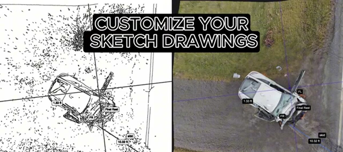
In accident reconstruction, forensic engineers use drone-derived maps to measure skid marks, vehicle rest positions, debris fields, sight distances, and roadway geometry with sub-inch precision. The 3D model preserves the spatial relationships between all of these features, allowing the engineer to run vehicle-dynamics simulations and testify to findings with a reproducible, auditable dataset behind them.
Accident reconstruction demands accurate spatial data quickly — before the scene is cleared and before conditions change. A SkyeBrowse orthomosaic export (GeoTIFF) provides a georeferenced top-down map that engineers import directly into reconstruction software for measurements and trajectory analysis. The accompanying 3D mesh (GLB) or point cloud (LAZ) adds elevation data useful for roadway super-elevation and sight-distance calculations.
Law enforcement agencies using SkyeBrowse routinely cut scene-documentation time from hours to under thirty minutes. See how Huntington Beach Police Department documents crash scenes with SkyeBrowse, and review a comprehensive breakdown of tools in best accident reconstruction software. The story behind SkyeBrowse's founding is itself rooted in a real crash reconstruction case — underscoring the direct connection between the platform's design and forensic engineering needs.
Can drones support structural failure and fire origin investigations?
Yes. For structural failures, drones provide an aerial view of collapse geometry, crack patterns, and displacement that is impossible or unsafe to capture from the ground. For fire investigations, a drone model of the burned structure maps char depth, burn patterns, and structural damage in three dimensions, giving investigators the spatial context to identify the area of origin without entering an unstable building.
Structural forensic engineering cases — building collapses, retaining-wall failures, bridge deck deterioration — often involve access hazards and large footprints that make ground-based documentation impractical. A drone safely maps a partially collapsed structure from multiple altitudes in a single flight, producing a 3D model that shows roof sag, wall lean, and differential settlement that ground photographs cannot convey. The same rapid aerial documentation capability that serves forensic investigators also powers disaster response operations, where structural damage assessment must happen within hours of an event.
Fire investigation benefits equally. The National Fire Protection Association's NFPA 921 guide emphasizes systematic scene documentation as the foundation of origin and cause analysis. A SkyeBrowse model of a fire scene captures the full burn pattern from above — showing V-pattern and low-burn indicators that point investigators toward the area of origin — creating a spatial record that strengthens expert reports and resists challenge in litigation. See also crime scene documentation equipment.
What outputs does SkyeBrowse deliver for forensic engineering cases?
SkyeBrowse produces three core deliverables from a single drone flight: a georeferenced 2D orthomosaic (GeoTIFF) for scaled measurements, a 3D mesh model (GLB) for spatial analysis and courtroom presentation, and a dense point cloud (LAZ) for import into CAD and engineering analysis software. All outputs are generated in the cloud at app.skyebrowse.com and shareable via a secure link without software installation.
The cloud-based delivery model is particularly valuable in forensic work, where experts and attorneys in different locations need to review the same dataset. SkyeBrowse's web viewer lets any stakeholder rotate, zoom, and take measurements from a browser with no software installation. For sensitive cases, AWS GovCloud hosting and CJIS-focused workflow options on premium tiers meet law-enforcement information security requirements — the same infrastructure requirements covered in the best CJIS compliant mapping platform guide.
Pricing follows a per-model credit system: Premium at $99/credit (0.25-inch accuracy) or Premium Advanced at $199/credit (0.1-inch accuracy). Both deliver exports suitable for expert reports and litigation packages. Visit skyebrowse.com/pricing-premium or request a quote for agency volume.
FAQ
What is forensic engineering?
Forensic engineering is the investigation of materials, products, structures, or components that have failed or not performed as intended, causing personal injury, property damage, or financial loss. Forensic engineers analyze physical evidence to determine the cause and origin of failures, and their findings support legal proceedings, insurance claims, and safety improvements.
How do drones help forensic engineers document accident scenes?
Drones capture comprehensive aerial video of an accident or failure scene in minutes. Videogrammetry software like SkyeBrowse converts that footage into accurate 3D models and 2D orthomosaic maps, creating a permanent, measurable digital record that can be reviewed by experts anywhere in the world or presented as evidence in court.
How accurate is drone mapping for forensic engineering?
SkyeBrowse's Premium Advanced tier achieves approximately 0.1-inch accuracy using 16K processing and AI moving-object removal. For most forensic engineering applications — crash reconstruction, structural failure analysis, fire origin mapping — the Premium tier's approximately 0.25-inch accuracy is sufficient for defensible expert testimony and litigation support.