If you've searched "photogrammetry vs orthomosaic," you may have encountered them framed as competing technologies. They aren't. Photogrammetry is the science of extracting measurements and spatial data from overlapping images, while an orthomosaic is one specific product that photogrammetry produces. Understanding this relationship — and knowing when each output type serves your workflow — is the key to getting the most from any drone mapping program.
Key Takeaways
- Photogrammetry is a measurement technique; an orthomosaic is one of several outputs it can generate — the two are not competing technologies.
- A single drone flight can produce three distinct output types simultaneously: an orthomosaic (2D map), a 3D mesh model, and a point cloud.
- Orthomosaics excel at area calculations, boundary documentation, and GIS import; 3D models are better for structural visualization, reconstruction, and court exhibits.
- According to the American Society for Photogrammetry and Remote Sensing (ASPRS), positional accuracy standards for orthoimagery depend on ground sample distance and overlap — factors controlled at the capture stage, not the processing stage.
- SkyeBrowse generates all three output types from a single video upload, removing the need to plan separate flights for different deliverables.
Contents
- What is photogrammetry?
- What is an orthomosaic and how is it made?
- Orthomosaic vs 3D model vs point cloud: which output do you need?
- How accurate are photogrammetry outputs?
- How does SkyeBrowse generate all three outputs from one flight?
- FAQ
What is photogrammetry?
Photogrammetry is the process of taking measurements from photographs. By analyzing how the same physical point appears across dozens or hundreds of overlapping images taken from slightly different positions, software can reconstruct the geometry of a scene — producing 2D maps, 3D models, and precise distance measurements without any physical contact with the subject.
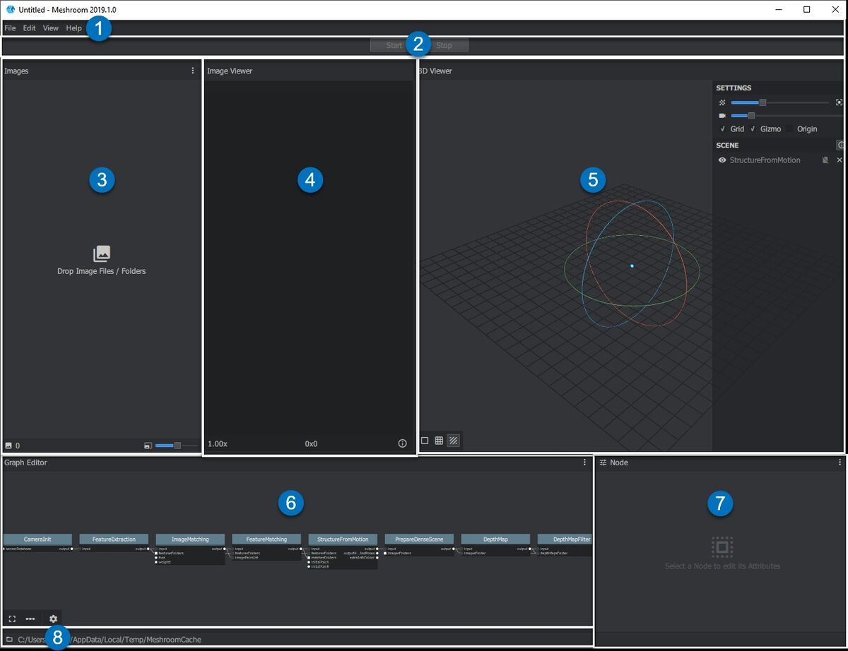
The word comes from the Greek roots for "light," "writing," and "measurement." Modern drone-based photogrammetry — sometimes called aerial photogrammetry — works by flying a drone in a systematic pattern over a site while the camera captures images at regular intervals. The software then identifies thousands of matching feature points across those images (a process called Structure from Motion, or SfM) and builds a geometric model of the scene.
Photogrammetry is a method, not a file type or a deliverable. The outputs it produces — orthomosaics, 3D meshes, point clouds, digital elevation models — are products of that method. The American Society for Photogrammetry and Remote Sensing (ASPRS) defines the discipline broadly enough to encompass all of them. For a practical introduction, see SkyeBrowse's guide to drone 3D mapping.
What is an orthomosaic and how is it made?
An orthomosaic is a large, georeferenced aerial image stitched together from hundreds of individual drone photographs. Unlike a standard aerial photo, an orthomosaic has been corrected for camera tilt and terrain relief (a process called orthorectification), which means every pixel represents a consistent ground scale. You can measure distances, areas, and angles directly on an orthomosaic as you would on a map.
The production pipeline runs through four stages: image capture, feature matching (SfM), dense point cloud generation, and orthorectification. During orthorectification, the software applies a digital elevation model to remove distortions caused by camera angle and terrain relief. The result is a seamless mosaic where every pixel represents a consistent ground scale.
Orthomosaics are delivered as GeoTIFF files — a raster format with embedded coordinate system data — making them directly importable into GIS tools like ArcGIS and QGIS. The USGS uses georeferenced orthoimagery as a foundational data layer for national mapping, and its Lidar Base Specification sets the positional accuracy benchmarks that commercial orthomosaic workflows are measured against.

Orthomosaic vs 3D model vs point cloud: which output do you need?
The right output depends on what you need to measure or communicate. Orthomosaics work best for 2D area analysis and GIS workflows. Three-dimensional mesh models are better for visualizing geometry, elevation changes, and structural details from any angle. Point clouds provide the raw spatial data that underpins both — and are the starting point for the most precise measurements.
Use the table below to match your use case to the right output type:
| Feature | Orthomosaic | 3D Mesh Model | Point Cloud |
|---|---|---|---|
| Format | GeoTIFF | GLB / OBJ | LAZ / LAS |
| Dimensions | 2D (top-down) | 3D (all angles) | 3D (raw points) |
| Best for | Area, boundary, GIS import | Visualization, reconstruction, court exhibits | Precise measurement, CAD/BIM integration |
| Measurable | Distance, area, perimeter | Distance, height, volume | Distance, volume, slope |
| File size | Medium | Large | Large |
| GIS compatible | Yes (native) | Limited | With conversion |
| Viewable by non-specialists | Yes | Yes (web viewer) | Requires specialist software |
| Common use cases | Agriculture, insurance, site planning | Accident reconstruction, inspections, construction progress | Surveying, engineering, digital twin |
Orthomosaics are the right choice when you need to hand a deliverable to a GIS team, calculate crop acreage, document property boundaries for an insurance claim, or compare site conditions across multiple dates — side-by-side orthomosaics make change detection straightforward.
Three-dimensional mesh models are the better option when you need to understand how a scene looks from ground level, communicate spatial relationships to a non-technical audience, or present evidence in court. A 3D model of a crash scene, for example, lets investigators walk through the scene virtually and measure sightlines in a way a flat orthomosaic cannot replicate. Read more about orthomosaic software for construction workflows specifically.
Point clouds occupy a different role: they are the dense set of georeferenced XYZ coordinates from which both orthomosaics and 3D meshes are derived. Engineers and surveyors working with CAD or BIM software often prefer to work directly with point clouds because they carry the most raw spatial information. ISO 19157, the international standard for geographic information data quality, provides the framework for evaluating the positional and completeness accuracy of point cloud datasets.
How accurate are photogrammetry outputs?
Accuracy in photogrammetry outputs is primarily a function of ground sample distance (GSD), image overlap, and flight altitude. Consumer-grade drone workflows at 400 feet altitude with 75 percent overlap can routinely achieve 2 to 6 inch absolute positional accuracy. High-precision workflows using ground control points (GCPs) and higher-resolution sensors can reach 0.1 to 0.25 inch accuracy.
GSD is the real-world size represented by one pixel. Flying lower and using a higher-resolution sensor both reduce GSD and improve accuracy. The ASPRS recommends at least 60 percent forward overlap and 30 percent sidelap for basic mapping, with 80/60 or higher for precision surveys.
Ground control points — physical markers at known coordinates — anchor the reconstruction to a real-world coordinate system. Workflows relying solely on drone GPS introduce more positional uncertainty. For legal evidence or engineering deliverables that demand sub-inch precision, GCPs are essential; for property boundary mapping or insurance documentation, 2 to 6 inch accuracy is typically sufficient.
Accuracy standards vary by output type. Orthomosaic accuracy is stated as root mean square error (RMSE) against ground check points. Point cloud accuracy is described by point density and vertical error. Mesh accuracy is derived from the underlying point cloud — it is only as precise as the point data beneath it.
How does SkyeBrowse generate all three outputs from one flight?
SkyeBrowse is a cloud-based videogrammetry platform that converts drone video footage — rather than separate still photos — into all three output types in a single processing run. Upload one video file and the platform returns a georeferenced orthomosaic (GeoTIFF), a 3D mesh model (GLB), and a point cloud (LAZ) without any additional configuration.
The videogrammetry approach treats video frames as a dense photo sequence — a one-minute clip at 30fps yields around 1,800 source images, more than most grid photo missions generate. SkyeBrowse's cloud pipeline runs SfM and multi-view stereo reconstruction entirely on AWS, so there is no desktop software to install.
Pairing video with a telemetry file (.SRT for DJI, .ASS for Autel) improves georeferencing precision. The Lite tier delivers 2 to 6 inch accuracy — sufficient for scene documentation and insurance. Premium at 8K narrows that to approximately 0.25 inch, and Premium Advanced adds AI moving-object removal for approximately 0.1 inch engineering-grade output.
Because all three deliverables come from one capture, field crews skip the separate flight planning that traditional workflows require. One flight covers every downstream need: GIS import, court exhibit, or survey deliverable.
FAQ
Is an orthomosaic the same as photogrammetry?
No. Photogrammetry is the measurement technique — the process of deriving spatial data from overlapping images. An orthomosaic is one type of output that the photogrammetry workflow can produce. Other outputs from the same process include 3D mesh models, point clouds, and digital elevation models.
When should I use an orthomosaic instead of a 3D model?
Use an orthomosaic when you need accurate 2D measurements, area calculations, or GIS integration — for example, crop analysis, insurance boundary documentation, or site planning. Choose a 3D model when you need to visualize height, depth, or geometry from multiple angles, such as for structural inspections, accident reconstruction, or construction progress monitoring.
Can one drone flight produce both an orthomosaic and a 3D model?
Yes. Platforms like SkyeBrowse process a single drone video capture into an orthomosaic (GeoTIFF), a 3D mesh model (GLB), and a point cloud (LAZ) simultaneously. This means you never have to choose at capture time — all three output types are generated from the same flight. See SkyeBrowse's full range of drone 3D mapping capabilities for details.
What file formats do photogrammetry outputs use?
Orthomosaics are typically delivered as GeoTIFF files for GIS compatibility. Three-dimensional mesh models are commonly exported in GLB or OBJ format for viewing in web browsers and 3D tools. Point clouds are delivered in LAZ or LAS format, which is compatible with most surveying and engineering software. SkyeBrowse supports all three export formats from a single processing run.
What is the difference between photogrammetry and LiDAR?
LiDAR uses laser pulses to measure distances directly, producing dense point clouds that penetrate vegetation canopy and work in low light. Photogrammetry derives geometry from overlapping photographs using computer vision. Photogrammetry is less expensive and more accessible for standard mapping; LiDAR is preferred where canopy penetration or sub-centimeter precision is required.