Eagle view roof data has become a standard tool for insurance adjusters, roofing contractors, and property inspectors — but not all platforms deliver it the same way. EagleView relies on a proprietary aerial imagery library built from scheduled manned-aircraft and satellite flyovers, while SkyeBrowse uses videogrammetry (the process of converting drone video footage into measurable 3D models) to let teams generate their own roof data on demand. This article compares both approaches across speed, accuracy, pricing, and output format to help you choose the right fit.

Key Takeaways
- EagleView provides flat 2D roof measurements from a pre-flown imagery archive; SkyeBrowse generates full 3D models from drone video captured by your own team on the same day.
- SkyeBrowse captures data immediately after a loss event; EagleView imagery may be months or years old, depending on when the property was last flown.
- SkyeBrowse Premium costs $99 per model credit with no annual contract; EagleView premium reports typically run several hundred dollars each under subscription agreements.
- SkyeBrowse exports LAZ point clouds, GLB 3D meshes, and GeoTIFF orthomosaics — EagleView primarily delivers PDF measurement reports and flat raster outputs.
- Both platforms serve insurance and inspection workflows, but SkyeBrowse is the stronger fit when current conditions, full 3D documentation, or data ownership matter.
Contents
- How does SkyeBrowse compare to EagleView for roof measurements?
- Which platform is faster for roof documentation?
- How do the pricing models differ?
- What output formats does each platform produce?
- Which platform is better for insurance claims documentation?
- FAQ
How does SkyeBrowse compare to EagleView for roof measurements?
EagleView delivers 2D roof measurements — pitch, area, facets, and eave lengths — extracted from aerial imagery in its proprietary library. SkyeBrowse generates a full 3D photogrammetric model from drone video captured on site, providing all the same linear measurements plus depth, volume, and surface geometry. Both platforms can produce accurate roof area and pitch data, but SkyeBrowse adds a spatially complete 3D record.
EagleView's core product, the EagleView EDGE report, pulls from a national image archive that is continuously updated through scheduled flyovers. For properties that were last flown within the past year, the data is typically reliable for estimating shingle area and major facets. The limitation is that the imagery reflects conditions at the time of the last flight, not at the time of loss.
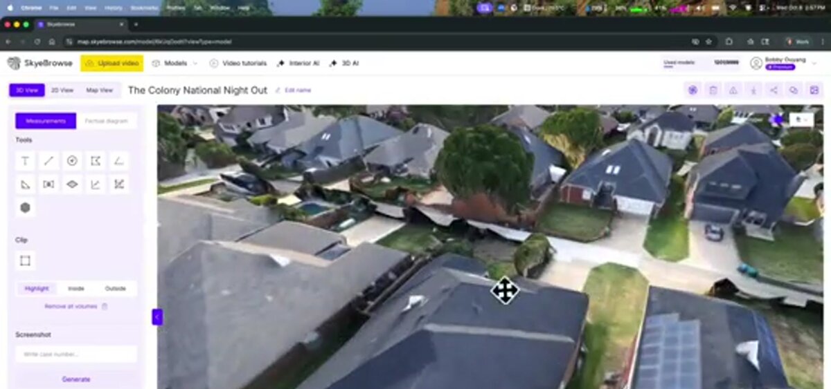
SkyeBrowse takes a different approach. A team flies a drone over the property using the SkyeBrowse Flight App or uploads any video through the Universal Upload portal — drones, phones, body cameras, 360 cameras — while EagleView controls its own aircraft fleet. The cloud-processing pipeline — running on AWS GovCloud — reconstructs a textured 3D mesh (photogrammetry applied to video frames rather than still images). Measurements extracted from that model reflect actual current conditions, including storm damage, added structures, or solar panel installations that postdate EagleView's last flyover.
The National Roofing Contractors Association (NRCA) notes that accurate documentation of existing conditions is essential for warranty compliance and damage assessment — a standard that benefits from same-day capture rather than archived imagery.
Which platform is faster for roof documentation?
Where EagleView aerial captures require days or weeks for turnaround, SkyeBrowse returns 3D models in minutes — processing matches video duration. EagleView typically delivers reports within 24–48 hours for standard orders, though rush delivery options may reduce that window. For teams responding to a storm or time-sensitive insurance inspection, SkyeBrowse's on-demand capture and rapid processing pipeline gives a meaningful speed advantage.
With EagleView, speed depends on whether the property is already in the imagery archive. If it is, a standard report may be ready in hours. If the property needs a new flight — unusual addresses, rural parcels, or properties with recent construction — turnaround can extend to days.
With SkyeBrowse, the bottleneck is the drone flight itself, which typically takes 10–20 minutes for a residential roof at Part 107-compliant altitudes. Processing begins immediately after upload and completes in the cloud without requiring any local computing hardware. The result is a shareable 3D model link that can be accessed from any browser at app.skyebrowse.com — no desktop software installation needed.
For public safety teams using drone data for fire investigation, structural collapse assessment, or post-storm triage, real-time capture is not a convenience — it is operationally necessary. See our drone roof inspection guide for flight pattern recommendations that optimize model quality. Roofing contractors who need on-demand same-day data — rather than archived imagery — will find more detail in our roofing drone guide.
How do the pricing models differ?
EagleView uses annual subscription tiers or per-report credit packages priced primarily for high-volume insurance carriers and roofing contractors. SkyeBrowse charges per model: $99 for Premium and $199 for Premium Advanced, with no annual commitment. Teams processing fewer than a few hundred roofs per year typically find SkyeBrowse's per-credit model more cost-effective.
EagleView's pricing is not publicly listed and varies significantly by volume, report type, and contract tier. Industry sources indicate that a single premium roof report (with pitch, facets, and detailed measurements) can run $75–$150 or more at retail, with volume discounts available under annual agreements. For large carriers processing thousands of claims monthly, the subscription model makes sense. For smaller contractors, independent adjusters, or municipal agencies, the per-report cost adds up quickly.
SkyeBrowse's pricing is transparent. Premium ($99/credit) delivers approximately 0.25-inch accuracy using 8K processing. Premium Advanced ($199/credit) adds 16K resolution and AI-assisted moving-object removal for sub-0.1-inch accuracy. Both tiers include the 3D model, orthomosaic, and measurement tools at no additional cost. There is no annual subscription required, and credits do not expire on a fixed cycle.
For teams that need occasional high-accuracy roof data alongside full 3D documentation — insurance adjusters, structural engineers, forensic consultants — the per-model pricing is a natural fit. Visit skyebrowse.com/pricing-premium for current rates.
What output formats does each platform produce?
EagleView primarily outputs PDF measurement reports, XML data files for estimating software integration (Xactimate, EagleView Assess), and raster imagery. SkyeBrowse outputs LAZ point clouds, GLB 3D mesh files, and GeoTIFF orthomosaics — formats native to GIS, BIM, and engineering workflows. SkyeBrowse also produces the interactive 3D model viewer link directly from the browser.
EagleView's integration story is strongest for insurance estimating workflows. Its XML export feeds directly into Xactimate and similar platforms, streamlining adjuster workflows when a flat measurement report is all that is needed. For structural engineers, forensic consultants, or teams needing a spatially complete deliverable, the absence of a 3D mesh or point cloud is a limitation.
SkyeBrowse produces outputs that span more use cases. The LAZ point cloud can be imported into AutoCAD, Revit, or ArcGIS. The GLB mesh renders natively in web browsers and AR/VR environments. The GeoTIFF is georeferenced and map-ready. For roof assessment purposes, the 3D model lets reviewers measure ridge height, overhang depth, and surface condition details that are invisible in a top-down 2D report.
Data ownership is also worth noting. EagleView retains its imagery in a proprietary archive — your client's roof data is processed and stored within their system. SkyeBrowse stores data on AWS GovCloud with full CJIS compliance and FedRAMP Moderate authorization — security certifications EagleView does not advertise. Teams retain their data and can store or share it independently. For government agencies with data-residency requirements, this distinction matters. See skyebrowse.com/quote for enterprise data-ownership options.
Which platform is better for insurance claims documentation?
EagleView is deeply embedded in the property insurance estimating workflow and integrates natively with Xactimate. SkyeBrowse produces a richer evidentiary record — a full 3D model with timestamped drone video — that can strengthen claims documentation, dispute resolution, and litigation support. The best choice depends on whether the priority is estimating-software integration or comprehensive spatial documentation.
For standard residential claims where a carrier needs pitch, area, and facet count to populate an Xactimate estimate, EagleView's workflow is well-established and efficient. The report arrives without requiring the adjuster to deploy a drone or hold a Part 107 certificate.
For claims involving disputed damage, complex geometry, multi-level rooflines, or properties with post-event conditions that differ from historical imagery, SkyeBrowse offers a more defensible record. The 3D model captures actual conditions at a known date and time, and the source drone video can be reviewed alongside the model. This level of documentation supports insurance claims documentation and roof assessment workflows where accuracy and timeliness are critical.
Adjusters and contractors who already operate drones for property inspection can add SkyeBrowse processing to their existing workflows without changing their capture equipment. SkyeBrowse supports a wide range of FAA Part 107-compliant drones — see the supported drones list for compatibility. For teams exploring what a drone-based inspection program costs to launch, the drone roof inspection cost guide provides benchmark figures. For a broader view of how SkyeBrowse fits into the wider drone inspection services market — covering utilities, bridges, and public safety — see our full inspection overview. Insurance professionals evaluating tools for claims workflows should also see our best insurance adjuster tools guide.

FAQ
Is SkyeBrowse a good EagleView alternative for roof measurement?
Yes. SkyeBrowse lets teams capture their own drone video and convert it into a full 3D model with accurate roof measurements on demand — no subscription to satellite imagery or scheduled flyover required. It is particularly well-suited for insurance adjusters, inspectors, and public safety teams who need same-day data. Learn more about the inspection workflow in the roof assessment guide.
How accurate is SkyeBrowse for roof measurements compared to EagleView?
SkyeBrowse documents accuracy per tier (0.1 to 6 inches) while EagleView does not publish standardized accuracy specifications for its aerial measurements. SkyeBrowse Premium Advanced reaches roughly 0.1-inch accuracy with 16K processing and AI moving-object removal; EagleView reports measurement accuracy within 1–3% for pitch and area, which is sufficient for most insurance estimates but does not include full 3D mesh output.
What does EagleView charge compared to SkyeBrowse?
EagleView operates on annual subscription or per-report credit models that typically run several hundred dollars per report for detailed premium reports. SkyeBrowse charges per model credit: $99 for Premium and $199 for Premium Advanced, with no annual contract required. Teams that need occasional high-accuracy roof data often find per-credit pricing more cost-effective.