Lake Sunapee's summer population doesn't grow — it erupts. Sunapee's year-round base of roughly 3,400 residents swells to more than three times that number when lakefront cottages fill, boat launches back up with trailers, and Route 11 becomes a two-lane corridor accommodating traffic volumes it was never designed for. A serious collision during Fourth of July weekend or Labor Day doesn't just close a road — it consumes officers who are already stretched thin across a town suddenly hosting a small city's worth of visitors. Then winter arrives with its own pressure: ice-covered two-lane roads through rolling terrain near Mount Sunapee Resort generate weather-related crashes that demand fast, accurate documentation before road treatment crews alter the evidence.
SkyeBrowse eliminates that tradeoff with patented videogrammetry — a method that converts drone or smartphone video directly into measurable 3D models — letting one officer document any scene in minutes while the rest of the shift stays on patrol.
Key Takeaways
- Route 11 crash documentation during summer season surges no longer pulls every available officer off patrol — one officer with existing gear captures the scene while colleagues handle the rest of the town.
- Winter road condition evidence — ice patches, frost heaves, skid marks — is preserved in a measurable 3D model before sand and salt treatment begins, protecting chain of custody for negligent homicide cases.
- SkyeBrowse produces forensic detail that holds up in Sullivan County Superior Court without supplementary scanning, satisfying New Hampshire court rules for digital demonstrative evidence in small-town jurisdictions.
- Processing runs at a 1:1 ratio — one minute of video equals one minute of processing — so the model is measurement-ready before Route 11 reopens to traffic.
- Shared cloud access lets New Hampshire Marine Patrol, Sullivan County Sheriff, and Sunapee PD review the same spatial data without transferring physical files between agencies.
Contents
- Why Sunapee Police Department Chose Videogrammetry
- Accident and Crime Scene Documentation
- CJIS-Compliant 3D Evidence for New Hampshire Courts
- Peak-Season Patrol Coverage and Year-Round Capability
- FAQ
Why Sunapee Police Department Chose Videogrammetry
Sunapee Police Department chose SkyeBrowse videogrammetry because the department's seasonal population surges create crash documentation demand that far exceeds what a small full-time force can absorb using traditional methods. By replacing multi-officer measurement teams with a single video capture, Sunapee PD preserves patrol coverage during the periods when the town needs it most.
Route 11 is Sunapee's lifeline. It connects the town to Interstate 89 and the regional hospital in New London. Collisions on this corridor — particularly during icy winter mornings or congested summer weekends — demand documentation that is both fast and thorough. Legacy tape-and-photo methods required enough officers to staff a measurement team, often pulling personnel from coverage positions across the town during the moments when the whole department was already managing an elevated call volume.
Seasonal population surges compound the problem. A single serious crash during a holiday weekend can tie up most of the available shift while tourists, boaters, and skiers sit in traffic on a road with no practical detour.
SkyeBrowse's Universal Upload accepts any .MP4 or .MOV file from drones, smartphones, body-worn cameras, or 360 cameras. Sunapee officers capture the scene with gear they already carry. No laser scanner. No total station. No call for a reconstruction specialist from Concord.
Processing runs at a 1:1 ratio. One minute of video produces one minute of processing time. The 3D model is available for measurement and sharing before the sand truck finishes treating the roadway.
Accident and Crime Scene Documentation
Sunapee PD uses SkyeBrowse to document crash scenes, crime scenes at seasonal properties, and incidents with multi-agency jurisdiction — all with a single video capture that produces a shareable, measurement-ready 3D model. The platform's cloud hosting lets the New Hampshire Marine Patrol, Sullivan County Sheriff, and Sunapee PD review the same spatial data without transferring physical files.
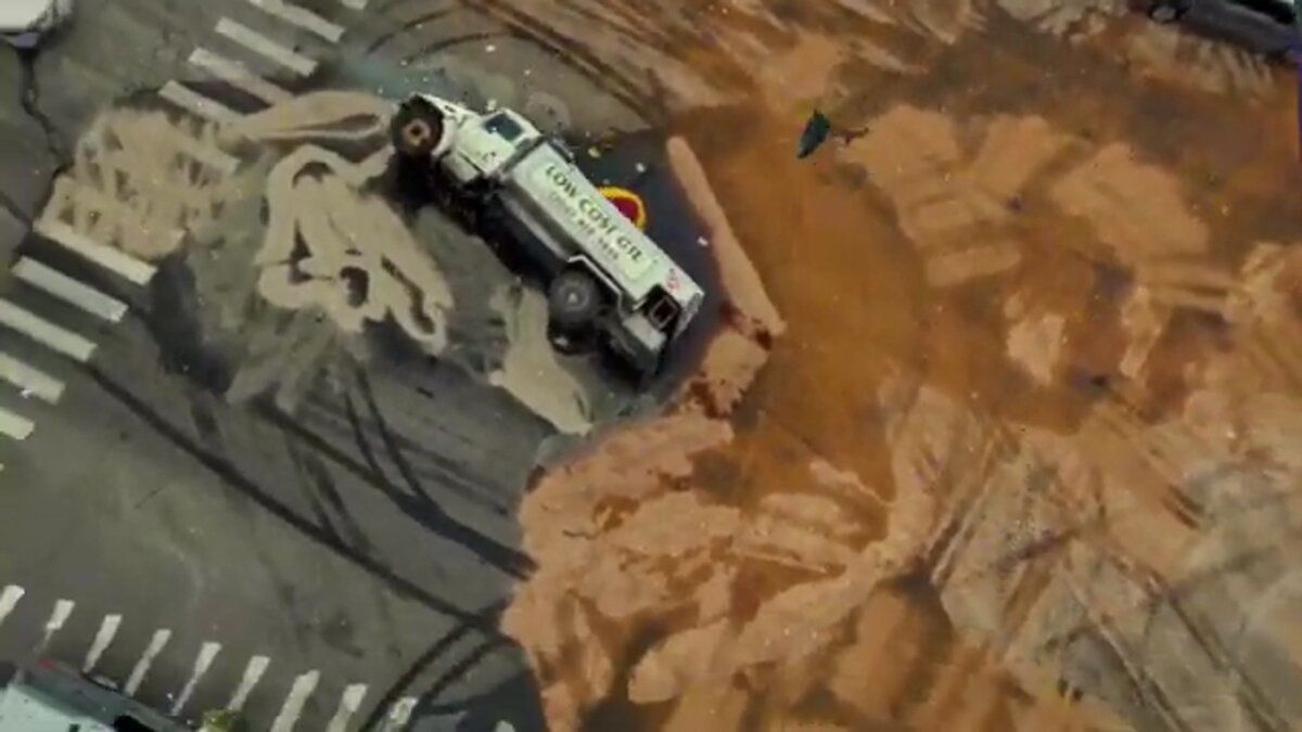
Sunapee's collision caseload reflects its geography: winding rural roads, steep grades near the ski area, frost heaves in spring, and black ice from November through March. Single-vehicle rollovers into stone walls and ditches are common, and multi-vehicle incidents at the Route 11 and Route 103B intersection spike during peak travel periods.
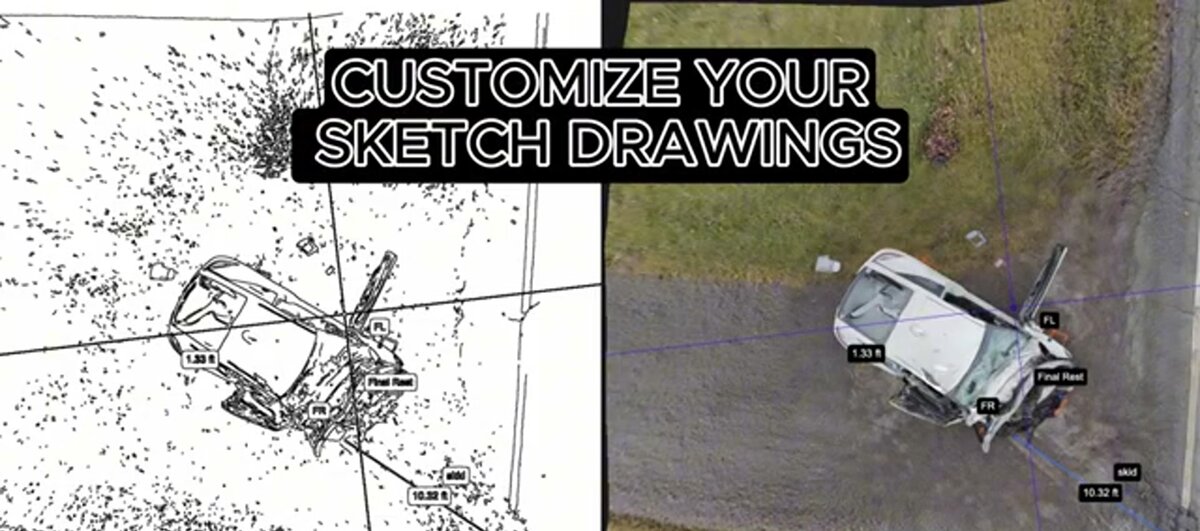
A single officer records a drone orbit or handheld video walkaround of the scene. SkyeBrowse converts the footage into a measurable 3D model that captures vehicle positions, road geometry, guardrail damage, and environmental conditions. Detectives and insurance adjusters can revisit the digital twin months later without returning to the location.
Crime scene documentation in a rural resort community has unique challenges. Scenes at lakefront properties, trailhead parking areas, and seasonal rental cabins may be accessible only by unpaved roads or boat. A smartphone video processed through SkyeBrowse produces the same court-ready model regardless of how the officer reached the scene.
Lake Sunapee itself creates jurisdictional complexity. Incidents on the water or at shared shoreline access points involve multiple agencies. A shareable 3D model hosted on SkyeBrowse's secure cloud lets the New Hampshire Marine Patrol, Sullivan County Sheriff, and Sunapee PD all review the same spatial data without transferring physical files.

CJIS-Compliant 3D Evidence for New Hampshire Courts
SkyeBrowse Premium Advanced produces forensic detail that holds up in Sullivan County Superior Court without supplementary scanning. New Hampshire court rules for digital demonstrative evidence require clear methodology and reproducible measurements — requirements SkyeBrowse satisfies through CJIS-aligned audit trails, cloud chain-of-custody documentation, and high-resolution models with sub-inch spatial accuracy.
Cases originating in Sunapee are heard in New Hampshire Superior Courts, Sullivan County. Vehicular assault and negligent homicide charges require precise spatial evidence, and prosecutors presenting in Claremont or Newport courtrooms need models that withstand defense scrutiny.
New Hampshire court rules for digital demonstrative evidence in small-town jurisdictions place particular weight on methodology transparency and chain-of-custody integrity. For rural departments without dedicated reconstruction units, the evidentiary bar can feel high — but SkyeBrowse satisfies it through documented capture methodology, CJIS-aligned audit trails that log every access event, and AWS GovCloud (US) hosting that keeps criminal justice data within a FedRAMP Moderate-aligned environment.
For Sunapee PD, two data security features prove especially relevant. First, the audit trail runs from moment of upload through every share and export action — giving prosecutors in small-jurisdiction courtrooms a complete record they can walk a judge through. Second, data retention on Premium and Premium Advanced tiers covers multi-year periods, accommodating seasonal-incident cases that take considerable time to reach trial while evidence remains fully intact on file.
GLB models give prosecutors lightweight 3D courtroom exhibits that walk juries through Route 11 collision geometry. GeoTIFF orthos integrate with county GIS layers when parcel-level spatial context matters to a case.
Peak-Season Patrol Coverage and Year-Round Capability
When Sunapee's population triples in summer, every officer off the road for crash documentation is an officer not covering the lake, the ski-area access roads, or the campground corridors. SkyeBrowse's one-officer documentation model means peak-season patrol coverage is maintained even on days when incidents stack up along Route 11 and the shoreline simultaneously.
For a department Sunapee's size, the staffing math during summer is unforgiving. A busy Saturday in July — a fender-bender on Route 11, a watercraft incident on the lake, a noise complaint at a vacation rental — can simultaneously demand more officer-hours than the on-duty shift can supply. Crash documentation that ties up multiple officers removes the slack the department needs to respond to anything else that hour.
With SkyeBrowse, the scene goes to one officer. That officer captures 10 minutes of video, uploads it, and the model processes while everyone else stays mobile. Peak-season patrol coverage on the lake corridor, the resort access roads, and the shoreline park areas remains intact. Neighboring agencies — New Hampshire Marine Patrol and Sullivan County Sheriff — don't need to absorb Sunapee's overflow when one of their own is pinned to a documentation task.
Winter road conditions create a different operational priority: speed of capture before evidence is altered. Ice patches, skid marks that trace a vehicle's pre-crash trajectory, and road geometry at the moment of impact all need to be locked into a 3D model before road treatment begins. SkyeBrowse's 1:1 processing ratio delivers that model fast enough that road crews can apply sand and salt without destroying the evidentiary record first.
According to NHTSA, rapid traffic incident clearance directly reduces secondary crash rates on high-volume corridors — a finding that applies to seasonal rural roads like Route 11 just as it does to interstates. Standardized capture quality means any officer on any shift produces court-ready results without specialized training, which matters on a rotating schedule where every responder may be first to arrive.
FAQ
How does SkyeBrowse help small police departments with limited staff?
For a department like Sunapee PD, the problem is not officer skill — it is officer availability when summer triples the population and incidents multiply with it. SkyeBrowse collapses scene documentation into a one-person task using gear officers already carry, so a small on-duty shift can document a serious crash completely and still have someone available for a second call. No neighboring departments need to be pulled in for measurement support.
Is SkyeBrowse evidence admissible in New Hampshire courts?
SkyeBrowse Premium Advanced produces forensic detail that holds up in Sullivan County Superior Court without supplementary scanning. New Hampshire court rules for digital demonstrative evidence in small-town jurisdictions require clear methodology and reproducible measurements. SkyeBrowse's CJIS-aligned audit trails and cloud chain-of-custody documentation satisfy those evidentiary standards for vehicular assault and negligent homicide proceedings heard in Claremont and Newport courtrooms. See skyebrowse.com/pricing-premium for tier details.
How does SkyeBrowse perform on winter roads and remote scene locations?
SkyeBrowse captures work offline — an officer records video on any drone or smartphone, then uploads when back in range. Winter road scenes with black ice, frost heaves, or low visibility are documented the same way as summer crashes. The processing speed means a model is ready before road crews finish applying sand or salt, so evidence of road surface conditions is preserved before treatment obscures it.
Get a SkyeBrowse Quote for Sunapee Police Department
Sunapee PD runs lean year-round and then faces months of peak demand with no surge capacity. SkyeBrowse fits that operating reality: documentation that one officer completes independently, court-ready evidence that satisfies Sullivan County Superior Court standards, and hardware compatibility with gear already on the patrol belt. If Sunapee is ready to reclaim the hours it loses to road-closure documentation and keep those officers where the town needs them during its busiest season, reach out for a quote tailored to a small-department budget.