Wine country tourism drives over 3.5 million visitors through Napa each year, and those visitors share every road with local commuters, delivery trucks, and agricultural equipment. Situated in Northern California's Napa County with a population around 80,000, the city straddles Highway 29 and the Silverado Trail — two narrow parallel corridors that are the only practical routes between the valley's wineries, tasting rooms, and downtown hospitality district. A single crash on either road blocks the only route available for miles in either direction. SkyeBrowse gives Napa PD a videogrammetry platform — videogrammetry converts continuous drone or smartphone video into measurable 3D models — that compresses scene documentation from a multi-hour operation to a ten-minute capture, restoring corridor access before tourist-season gridlock becomes permanent.

Key Takeaways
- Highway 29 and the Silverado Trail are single points of failure — one crash closes the only route for miles, so average road clearance time is the metric that matters most to Napa PD.
- The Silverado Trail's blind curves and minimal shoulder historically required officers to park patrol vehicles in live lanes while stretching measuring tapes across asphalt; SkyeBrowse eliminates that exposure entirely.
- SkyeBrowse Premium Advanced delivers measurement detail that closes the gap between field documentation and the expert analysis wine country accident attorneys demand in civil litigation following high-profile crashes.
- Post-flood documentation of Napa River levee roads is captured by drone orbit without officers entering hazardous ground conditions.
- Napa PD handles DUI fatalities and vehicular manslaughter charges across a jurisdiction that swells with visitors on weekends — faster scene documentation keeps more officers on DUI enforcement corridors.
Contents
- Why does average road clearance time matter so much on Napa's two-lane wine country corridors?
- How does Napa PD document crash and crime scenes across the valley?
- Does SkyeBrowse evidence meet Napa County Superior Court and civil litigation standards?
- How does SkyeBrowse preserve tourist season traffic flow during the documentation window?
- FAQ
Why does average road clearance time matter so much on Napa's two-lane wine country corridors?
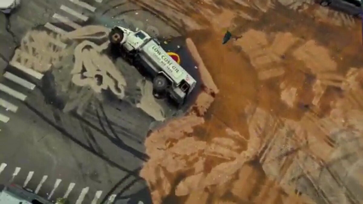
Highway 29 and the Silverado Trail are not arterials with parallel bypass options — they are single-corridor routes through vineyard terrain. One crash pinches traffic to a complete stop with no alternate path for miles. SkyeBrowse reduces the documentation window on those corridors from a multi-hour manual operation to about ten minutes, which is the difference between a brief inconvenience and valley-wide gridlock during harvest weekend.
Highway 29 through Napa narrows at intersections near Trancas Street and Lincoln Avenue, where collisions back up traffic through the downtown core within minutes. The Silverado Trail, running parallel along the eastern hillside, offers no practical bypass — its blind curves, steep grades, and minimal shoulder space mean closures there ripple immediately into winery access roads and rural residential routes with no capacity to absorb the overflow.
Traditional tape-and-total-station reconstruction methods were not designed for corridor environments this constrained. When the only road for miles is closed for an extended period, winery shuttle buses, delivery vehicles serving the hospitality district, and tourist rental cars all divert onto secondary roads that were never built for that volume. The economic disruption compounds by the minute during crush season.
Napa PD officers now capture a complete scene with hardware already in their patrol kit. No specialized scanner, no tripod setup. The resulting 3D model is available before lane cleanup is complete — fast enough to restore both Highway 29 and the Silverado Trail before a single backup becomes a day-long traffic event.
How does Napa PD document crash and crime scenes across the valley?
Napa's collision profile spans tourist-rental-car sideswipes on downtown First Street to high-speed head-on crashes near the Yountville border, plus seasonal flood events along the Napa River levee roads. A single officer flying a drone orbit or walking a handheld video path captures vehicle positions, road markings, skid marks, and environmental context in one continuous pass.
Each type of scene in Napa demands thorough spatial documentation, but the department cannot afford to hold multiple officers at a single location when both primary corridors need patrol presence. With SkyeBrowse, one officer executes the capture while others maintain coverage on Highway 29 and the Silverado Trail.
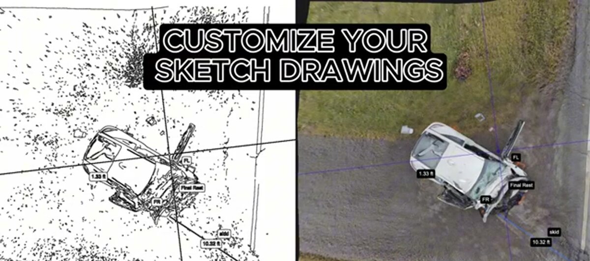
The resulting 3D model captures vehicle positions, road markings, skid marks, and the environmental context that gives those measurements meaning — grade changes on the Silverado Trail, sight-distance limitations at a vineyard driveway, the exact geometry of the Trancas Street intersection. Detectives reviewing the model later can rotate, zoom, and measure without returning to the physical location.
Property crimes in the downtown tourist district, vehicle pursuits that end along the river levee roads, and violent incidents near the Pueblo Avenue corridor benefit from the same rapid spatial capture workflow. Evidence markers, shell casings, and vehicle final rest positions are preserved in a digital record prosecutors can present in Napa County Superior Court.
The Napa River flooding zones add seasonal urgency. Post-flood debris fields and water-damaged structures need documentation before conditions change. A drone video pass creates a permanent spatial record even when ground access is limited by standing water or unstable levee road surfaces.

Does SkyeBrowse evidence meet Napa County Superior Court and civil litigation standards?
Napa County Superior Court processes DUI fatalities and vehicular manslaughter charges shaped by the valley's particular mix of alcohol-adjacent tourism and high-speed rural roads. Beyond criminal prosecution, high-profile crashes near Napa's hospitality venues generate civil litigation where wine industry accident attorneys demand measurement detail that goes well beyond a photograph and a hand-written diagram. SkyeBrowse Premium Advanced delivers exactly that.
The precision required for vehicular homicide prosecution in Napa County is not approximate — it is forensically defensible. SkyeBrowse Premium Advanced produces models where every measurement is derived from the same continuous video source, creating a reproducible process that expert witnesses on either side can audit step by step. That audit trail is precisely what closes the gap between field documentation and the expert analysis wine country accident attorneys demand in both criminal and civil proceedings.
Civil litigation following high-profile crashes near Napa's hospitality venues often involves multiple parties: the drivers, the property owners, the venue operators, and their insurers. Each party's expert will scrutinize how the scene was documented and whether the measurements are independently verifiable. SkyeBrowse's GLB mesh exports give attorneys and jurors an interactive 3D walkthrough of the collision scene, and LAZ point cloud exports integrate with the forensic CAD tools accident reconstruction specialists use for speed and trajectory analysis.
Evidence stores on AWS GovCloud infrastructure with CJIS-aligned audit logs that record every access event from upload through trial. Defense counsel or plaintiff attorneys requesting discovery receive a model paired with a complete access history — no gaps in the chain. GeoTIFF orthomosaics can be layered directly into the county's GIS platform alongside parcel data and FEMA flood-zone maps, giving investigators spatial context that extends beyond the crash footprint. See the IACP Law Enforcement Policy Center for guidance on digital evidence standards that SkyeBrowse's workflows are designed to support.
How does SkyeBrowse preserve tourist season traffic flow during the documentation window?
Napa PD covers roughly 80,000 residents plus a tourist population that peaks at several times that figure on harvest weekends. The department's roster is sized for the resident population, not the visitor surge — which means every hour spent on extended scene reconstruction is an hour pulled from DUI patrols on Highway 29, foot beats in the hospitality district, and enforcement at the event venues that generate the bulk of alcohol-related calls.
Videogrammetry shifts that operational equation. One officer documents the scene while the rest of the shift stays in service on the corridors that need coverage most during peak tourist periods. On a busy harvest weekend when both Highway 29 and the Silverado Trail are running at capacity, that staffing headroom is the difference between adequate enforcement presence and a dangerous gap in DUI patrol coverage.
Faster scene clearance on the valley's two-lane corridors limits the economic ripple effect of extended closures. Winery shuttles, delivery trucks serving the hospitality district, and tourist rental vehicles all divert when Highway 29 backs up, pushing onto secondary roads not designed for that volume. Compressing the documentation window to under ten minutes contains that disruption before it cascades through Napa's road network and starts generating secondary incident risk on roads that can't handle the overflow.
NHTSA's Traffic Safety Facts data shows that secondary crash risk rises meaningfully during extended primary scene closures. On single-corridor roads like Highway 29 and the Silverado Trail, where there is no bypass to absorb diverted traffic, minimizing that window is as much a safety decision as a logistics one.
FAQ
How does SkyeBrowse help Napa PD clear two-lane wine country roads faster after a crash?
SkyeBrowse lets a single Napa officer capture a complete crash scene on Highway 29 or the Silverado Trail using drone or smartphone video in about 10 minutes. Because these two-lane vineyard corridors have no bypass alternatives, compressing documentation time directly shortens the road closure window and limits the traffic cascade that backs up through adjacent winery access roads. Learn more at skyebrowse.com/tutorials.
Is SkyeBrowse evidence accepted by Napa County Superior Court and wine industry civil litigants?
Yes. SkyeBrowse Premium Advanced delivers measurement detail that closes the gap between field documentation and the expert analysis wine country accident attorneys demand — in DUI fatality cases, vehicular manslaughter charges, and the civil litigation that follows high-profile crashes near Napa's hospitality venues. Evidence stores on AWS GovCloud with CJIS-aligned audit trails that meet Napa County Superior Court chain-of-custody standards. See skyebrowse.com/pricing-premium for tier details.
How does SkyeBrowse handle post-flood scene documentation in the Napa River floodplain?
A drone video pass over flood-affected areas creates a permanent spatial record of debris fields and water-damaged structures even when ground access is limited. The resulting 3D model captures terrain changes and evidence positions before conditions change, without requiring officers to enter unsafe areas.
Get a SkyeBrowse Quote for Napa Police Department
Wine country policing means managing a corridor economy where extended lane closures have measurable consequences and a lean patrol roster where every officer on scene reconstruction is one fewer officer on DUI enforcement. SkyeBrowse fits both constraints. Contact us to see how the platform handles Highway 29 and Silverado Trail scenarios specific to Napa's operational environment.