Three distinct village centers, a winding stretch of the Cahaba River, and multiple active school zones define Mountain Brook. This Jefferson County suburb of Birmingham holds about 21,000 residents across hilly terrain where U.S. Route 280 serves as both a regional commuter artery and a local shopping corridor. When a crash occurs near Mountain Brook Elementary or the village commercial blocks during pickup and dropoff windows, the department faces a dual pressure: document the scene thoroughly and reopen the road before queued parent traffic creates a second safety hazard in the neighborhood.
Mountain Brook PD selected SkyeBrowse — a videogrammetry platform that converts drone or smartphone video into measurable 3D models — to meet that standard without pulling its compact force off residential patrol.
Key Takeaways
- Crashes near school zones during pickup and dropoff times create safety emergencies where fast documentation and road reopening prevent secondary hazards from queued parent traffic.
- U.S. Route 280 narrows through Mountain Brook's village commercial districts, where angle collisions require precise grade and curve measurements SkyeBrowse captures in a single drone orbit.
- Ridgeline roads and Cahaba River embankments create multi-elevation scenes where vehicles sometimes come to rest below road level — 3D models reveal positions that flat-plane diagrams misrepresent entirely.
- Cases reaching Jefferson County Circuit Court face defense experts who scrutinize measurement precision; SkyeBrowse delivers geometric accuracy that Jefferson County reconstruction experts independently verify, meeting Alabama Rules of Evidence standards.
- With three village centers, active parks, and school zones all needing coverage, shifting multiple officers to one scene for hours degraded patrol capacity across every quadrant — SkyeBrowse reduces documentation to one officer.
Contents
- Why Mountain Brook Police Department Chose Videogrammetry
- Accident and Crime Scene Documentation
- CJIS-Compliant 3D Evidence for Alabama Courts
- School Zone Safety and Neighborhood Disruption Minimized
- FAQ
Why Mountain Brook Police Department Chose Videogrammetry
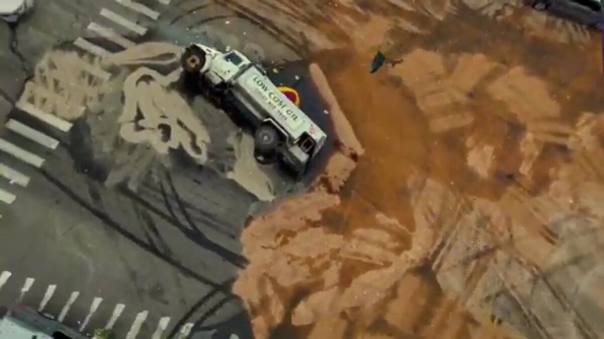
U.S. Route 280 through Mountain Brook narrows at village commercial districts, generating angle collisions and pedestrian incidents that traditional reconstruction addressed with multiple officers and hours of lane closures — backing traffic into downtown Birmingham. When those closures coincided with school dismissal, the disruption cascaded into residential streets that double as pickup routes. SkyeBrowse compresses that timeline to one officer and 10 minutes, preserving roadway geometry including grade changes and curve radii that manual methods struggle to capture.
U.S. Route 280 through Mountain Brook is one of the most congested corridors in the Birmingham metro. The road narrows as it passes through the village commercial districts, and left-turn conflicts at unsignalized driveways generate a steady stream of angle collisions. Jemison Park's trailheads attract pedestrians who cross 280 on foot, adding vulnerable-road-user incidents to the caseload.
Traditional reconstruction on this corridor required officers measuring grades, curves, and sight distances across terrain that changes elevation rapidly. Extended lane closures on 280 backed traffic into downtown Birmingham and triggered secondary crashes on parallel residential streets — including the same streets parents use for school pickup.
SkyeBrowse compresses that timeline. One officer captures continuous video from a drone orbit or handheld walk. The resulting 3D model preserves the roadway geometry, including grade changes and curve radii that manual methods struggle to capture accurately.
Mountain Brook PD uses equipment already on hand, avoiding a separate procurement cycle.
Accident and Crime Scene Documentation
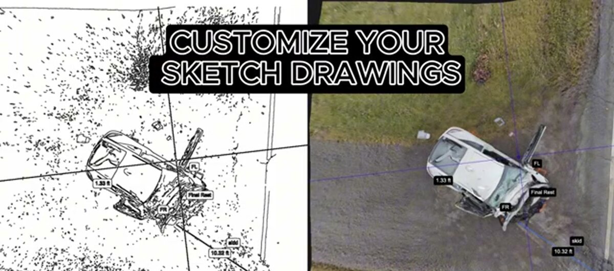
Mountain Brook's ridgeline roads and Cahaba River embankments create elevation differences within single intersections that flat-plane diagrams miss entirely. SkyeBrowse captures these scenes in about 10 minutes, recording full three-dimensional context so analysts measure distances, sight lines, and grade percentages directly from the model without returning to the roadway.
Mountain Brook's topography creates unique documentation challenges. Roads follow ridgelines and river bluffs, and collision scenes often span multiple elevation changes within a single intersection. The Cahaba River corridor adds embankments and bridge approaches where vehicles come to rest in positions difficult to measure with traditional tools.
SkyeBrowse captures these scenes in about 10 minutes. A drone orbit records the full three-dimensional context, including elevation differences that flat-plane diagrams miss. Analysts measure distances, sight lines, and grade percentages directly from the model without returning to the roadway.
Near school zones, the documentation value is especially clear. A crash on Euclid Avenue near Mountain Brook High School or on Cherokee Road near the elementary campus requires both complete spatial capture and rapid clearance. SkyeBrowse delivers both simultaneously — one officer handles the documentation pass while the remaining shift maintains the residential patrol coverage that parents and school administrators expect.
Residential neighborhoods feature mature tree canopies, winding streets, and limited street lighting. A handheld video walk through a burglary scene or a vehicle-pursuit endpoint produces a spatial record that detectives review remotely, reducing repeat site visits and preserving evidence context.
Cloud-based sharing supports coordination with Jefferson County investigators and Birmingham metro task forces that occasionally assist on major cases.

CJIS-Compliant 3D Evidence for Alabama Courts
Alabama Circuit Courts apply evidentiary standards that require measurement precision independently verifiable by defense experts. SkyeBrowse Premium Advanced delivers geometric accuracy that Jefferson County reconstruction experts independently verify — satisfying Alabama Rules of Evidence for expert testimony and the evidentiary bar of the Tenth Judicial Circuit handling Mountain Brook cases.
Mountain Brook cases move through Alabama's Tenth Judicial Circuit, where Jefferson County prosecutors and defense counsel both retain reconstruction experts who will independently verify every measurement in the model. The expectation under Alabama Rules of Evidence is not simply that measurements exist — it is that they are independently reproducible and that the evidence file itself has an unbroken chain of custody from the moment of capture.
SkyeBrowse's Premium Advanced tier addresses both requirements. The platform produces geometric accuracy that Jefferson County reconstruction experts independently verify, giving defense-side analysts the detail fidelity they need for trajectory and energy-transfer analysis while giving prosecutors a model that survives Daubert-style challenges in Circuit Court. The underlying infrastructure logs every interaction with the evidence file, creating the same kind of accountability record a physical evidence room provides. Data retention on Premium and Premium Advanced tiers means cases that move slowly through the Alabama court system still have accessible evidence when they reach disposition.
For courtroom presentation, GLB models give jurors an interactive 3D view they can understand without technical training. LAZ point clouds go to experts on both sides who need raw data for independent analysis.
School Zone Safety and Neighborhood Disruption Minimized
Mountain Brook's small department cannot lose multiple officers to a single scene for hours without degrading coverage across village centers, parks, and school zones. SkyeBrowse compresses documentation to one officer in about 10 minutes, allowing the road to reopen before school dismissal traffic backs into residential streets — and keeping the rest of the shift available for the patrol coverage neighborhoods expect.
Mountain Brook is a compact department protecting a geographically spread jurisdiction of three village centers, multiple parks, and several school zones. When a crash on Route 280 or near a school campus historically pulled multiple officers for an extended reconstruction, the entire southern sector of the city went with them. Every minute on that scene was a minute without coverage in English Village or Crestline Village.
The school zone dimension adds urgency that a standard cost-per-scene calculation misses. A crash on Cherokee Road at 2:45 PM during school dismissal is not just a documentation problem — it is a safety emergency where queued parent traffic, distracted drivers, and pedestrian children are all in proximity. SkyeBrowse's speed advantage directly addresses that window: one officer captures documentation while the road clears, rather than holding the closure through the full pickup period.
Faster clearance on Route 280 carries additional benefits beyond the school context. Extended lane closures push traffic onto Overbrook Road and the residential streets that wind through the ridgeline neighborhoods, increasing secondary crash exposure. Closing in minutes rather than hours contains that risk and preserves the community character Mountain Brook residents and officials prioritize.
Consistent capture protocol ensures that every officer produces comparable forensic models regardless of seniority, preserving institutional knowledge in digital form and reducing dependence on a single reconstruction specialist whose availability previously determined when a case file got its documentation.
FAQ
How does SkyeBrowse help Mountain Brook PD reopen school zone crash scenes quickly?
One officer captures a complete school zone crash scene using drone or smartphone video in about 10 minutes. SkyeBrowse processes that footage into a measurable 3D model while the scene is still secured, allowing the road to reopen before pickup or dropoff traffic backs into residential streets. The model preserves crosswalk geometry, vehicle positions, and sightline obstructions so investigators can measure and analyze without any return visit. Learn more at skyebrowse.com/tutorials.
Is SkyeBrowse evidence admissible in Jefferson County Circuit Court under Alabama Rules of Evidence?
Yes. SkyeBrowse Premium Advanced delivers geometric accuracy that Jefferson County reconstruction experts independently verify — satisfying the evidentiary precision standard that Alabama Rules of Evidence require for expert testimony in Circuit Court proceedings. The platform's CJIS-ready infrastructure and complete audit trail establish an unbroken chain of custody from field capture through courtroom presentation.
Can SkyeBrowse capture the elevation changes on Mountain Brook's ridgeline roads accurately?
Yes. Mountain Brook's ridgeline roads and Cahaba River embankments create elevation differences that flat-plane diagrams cannot represent. A drone orbit captures full three-dimensional geometry including grade percentages and curve radii. Analysts can measure these directly from the model — no return visit required — which is especially valuable when scenes along the Cahaba corridor involve vehicles that came to rest below road level.
Get a SkyeBrowse Quote for Mountain Brook Police Department
Mountain Brook PD protects three village centers and a major regional corridor with a roster that cannot absorb hours-long scene commitments — especially when those commitments overlap with school dismissal windows and residential neighborhood patrol. SkyeBrowse fits that reality: forensic-grade documentation from equipment you already own, closed in minutes, court-ready for the Jefferson County Circuit Court. Reach out to see the platform applied to your specific corridors and crime scene types.


