Pierce County operates on mutual aid. Departments from Fife to Bonney Lake to Sumner have long relied on each other when a complex collision demanded reconstruction resources that no single agency carried internally. That arrangement sounds cooperative on paper, but in practice it means one department's major crash drains officers from another's patrol zone, creating a cascade of coverage gaps across the county. Puyallup's convergence of SR-512 and SR-167 — the interchange that funnels commuter and commercial traffic between Tacoma, the South Hill retail corridor, and the Washington State Fairgrounds — generated more of those mutual aid requests than almost any other node in Pierce County. SkyeBrowse's patented videogrammetry ends that cycle by giving Puyallup PD the ability to produce complete, measurable 3D reconstruction models with one officer, independently, in under 10 minutes.

Key Takeaways
- SR-512 and SR-167 scenes that once triggered mutual aid requests to neighboring Pierce County departments are now resolved independently by one Puyallup officer in under 10 minutes using SkyeBrowse videogrammetry.
- Eliminating outbound mutual aid requests means neighboring departments like Fife and Sumner keep their patrol units available — county-wide response capacity improves every time Puyallup handles its own reconstruction.
- During the three-week Washington State Fair — when daily attendance tops 100,000 — rapid documentation prevents cascading road closures on corridors already at capacity.
- SkyeBrowse Premium Advanced delivers measurement precision that Pierce County prosecutors rely on for vehicular homicide cases, with models admissible in Pierce County Superior Court under Washington RCW.
- Hardware flexibility means the department uploads footage from any drone or camera it already owns — no laser scanner, no dedicated processing workstation, no county reconstruction team needed.
Contents
- Why Puyallup Police Department Chose Videogrammetry
- Accident and Crime Scene Documentation
- CJIS-Compliant 3D Evidence for Washington Courts
- Mutual Aid Reduction and County-Wide Self-Sufficiency
- FAQ
Why Puyallup Police Department Chose Videogrammetry
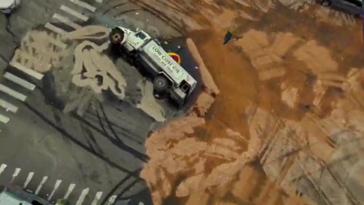
The SR-512 and SR-167 interchange generates more collision calls per shift than any other corridor in Puyallup. Getting that intersection reopened in 10 minutes instead of three-plus hours required a documentation method that one officer could execute independently, without requesting reconstruction support from neighboring departments. SkyeBrowse's video-based workflow let the department start using equipment it already owned on day one.
The SR-512 and SR-167 interchange is Puyallup's highest-volume collision zone. Merging traffic, rain-slicked pavement for much of the year, and commercial vehicles heading to and from the Port of Tacoma create a steady caseload of multi-vehicle crashes that demand thorough documentation. Legacy methods required multiple officers with tapes, total stations, and photo logs — and when scenes grew complex enough, Puyallup would call for reconstruction assistance from neighboring agencies, pulling those departments away from their own patrol commitments.
Meridian Avenue and South Hill's dense retail corridors generate a second tier of incidents: parking lot collisions, pedestrian strikes near shopping centers, and intersection crashes at signalized crossings. Each one pulls patrol units from a district that already struggles with coverage during peak retail hours.
SkyeBrowse accepts video from drones, smartphones, body-worn cameras, or 360 cameras — whatever the department already carries. No laser scanner rental. No waiting for a county reconstruction team to respond from downtown Tacoma. No mutual aid request that creates a staffing hole in a neighboring city.
Cloud processing turns that video into a finished, measurable 3D model fast enough that the intersection can reopen before the tow truck finishes clearing debris.
Accident and Crime Scene Documentation
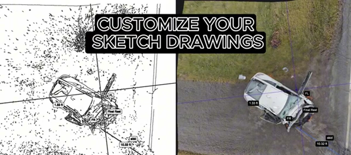
A single Puyallup officer captures a collision scene with a drone orbit or handheld video walkaround and uploads it to SkyeBrowse. The platform returns a measurable 3D model preserving skid marks, debris fields, vehicle positions, and road geometry that detectives and prosecutors can revisit months later without returning to the physical location.
Puyallup's collision caseload peaks during two predictable windows: morning and evening commuter rushes on SR-512, and the three-week Washington State Fair in September, when daily attendance can exceed 100,000 visitors. Fair-related traffic spills onto local streets, creating fender-benders and pedestrian incidents that the department must document quickly to avoid cascading road closures.
A single officer captures the scene with a drone orbit or handheld video walkaround. SkyeBrowse converts that footage into a measurable 3D model that preserves skid marks, debris fields, vehicle positions, and road geometry. Detectives and prosecutors can revisit the digital twin months later without returning to the physical location.
Crime scene documentation across Puyallup's varied geography — incidents along the river trail system, property crimes in the downtown historic district, and vehicle pursuits ending in residential neighborhoods — benefits from rapid spatial recording. Evidence markers and the spatial relationships between objects are locked into the model permanently.
The Pacific Northwest's frequent overcast skies and low-light conditions during winter months do not degrade capture quality. Video-based input is more forgiving of flat lighting than traditional photo-grid methods, and SkyeBrowse's processing algorithms compensate for consistent cloud cover.

CJIS-Compliant 3D Evidence for Washington Courts
SkyeBrowse Premium Advanced delivers measurement precision that Pierce County prosecutors rely on for vehicular homicide cases. Data is stored on AWS GovCloud infrastructure with CJIS-ready audit trails, satisfying Pierce County Superior Court digital evidence standards for spatial exhibits used in vehicular assault and vehicular homicide proceedings under Washington RCW.
Cases originating in Puyallup move through the Pierce County Superior Court system. Vehicular assault and vehicular homicide charges under Washington RCW carry significant penalties, and prosecutors need measurement data that defense experts cannot credibly challenge. Pierce County Superior Court's digital evidence standards demand spatial exhibits with documented chain of custody, clear methodology, and verifiable accuracy.
SkyeBrowse Premium Advanced delivers high-resolution models with sub-inch accuracy. Automated removal of transient objects — emergency vehicles, bystanders, passing traffic — produces a forensically clean scene representation reflecting conditions at the time of the incident rather than the chaotic minutes after first responders arrived.
The underlying security architecture matters as much as the spatial data. All SkyeBrowse models are stored on AWS GovCloud infrastructure aligned with FedRAMP Moderate controls and CJIS security requirements. Every access event is logged, sharing is permission-controlled, and data retention spans multiple years on Premium and Premium Advanced tiers. For a vehicular homicide case that may not reach trial for 18 months, that retention guarantee removes a category of evidentiary risk that older documentation methods cannot address.
GLB models give Pierce County prosecutors a format that jurors can follow on screen without specialized software. For cases requiring integration with county GIS data — such as establishing sight lines at signalized intersections — models can be exported in formats compatible with Pierce County's spatial infrastructure.
Mutual Aid Reduction and County-Wide Self-Sufficiency
Every mutual aid request Puyallup eliminates is a patrol unit returned to a neighboring department. SkyeBrowse's one-officer workflow means Puyallup handles its own reconstruction independently — freeing agencies like Fife, Sumner, and Bonney Lake to stay focused on their own corridors rather than staffing Puyallup's crash scenes.
The mutual aid math in Pierce County is straightforward: when Puyallup calls for reconstruction support, a neighboring department answers by pulling officers off their own patrol zones. Across a year's worth of SR-512 incidents, those outbound requests accumulate into a meaningful drag on county-wide patrol capacity.
With SkyeBrowse, Puyallup handles reconstruction internally. One officer, one video, one upload — and a finished 3D model is ready before the scene clears. Neighboring departments stop receiving mutual aid calls for reconstruction work, and their officers stay available for their own districts.
The operational shift is most visible during Washington State Fair weekends, when the entire South Hill and Puyallup corridor is under heightened demand. A department that can handle its own documentation without pulling adjacent resources is a more reliable partner within Pierce County's mutual aid network — contributing to it rather than drawing from it.
Training new officers on consistent documentation also simplifies quality control. Because every model is produced through the same cloud workflow, supervisors reviewing evidence from multiple officers see comparable outputs rather than inconsistent hand-drawn sketches with varying levels of detail.
FAQ
How does SkyeBrowse help Puyallup Police Department close roads faster?
On the SR-512 and SR-167 interchange — Puyallup's busiest collision zone — SkyeBrowse cuts documentation time from roughly 3 hours to 10 minutes. One officer flies a drone orbit or conducts a handheld video walkaround, uploads the footage, and has a measurable 3D model ready before the wrecker finishes rigging. That speed means the intersection reopens before Tacoma-bound traffic backs up onto the freeway ramps.
Is SkyeBrowse evidence admissible in Washington State courts?
Yes. SkyeBrowse Premium Advanced delivers measurement precision that Pierce County prosecutors rely on for vehicular homicide cases. Models are stored on AWS GovCloud infrastructure with CJIS-ready audit trails that give prosecutors a complete, defensible chain of custody from drone capture through courtroom presentation. Pierce County Superior Court digital evidence standards for spatial exhibits are met through the combination of high-resolution output, audit logging, and structured data retention. Learn more about SkyeBrowse's CJIS-compliant workflows.
What happens to SkyeBrowse data if Puyallup PD changes drone hardware?
Nothing changes in the workflow. SkyeBrowse accepts standard video files from any drone model, smartphone, body-worn camera, or 360 camera. If the department upgrades from a DJI Mavic 3 to a newer platform, the upload process and the model outputs remain identical. Officers do not need retraining when hardware changes. See the full list of supported drones.
Get a SkyeBrowse Quote for Puyallup Police Department
Puyallup's traffic corridors do not pause for manual documentation, and Pierce County's patrol network cannot absorb unlimited mutual aid requests. If the department is ready to clear SR-512 scenes in 10 minutes, produce Pierce County Superior Court-ready evidence independently, and keep neighboring departments focused on their own districts, contact SkyeBrowse to discuss licensing and deployment timelines.