Fire scenes degrade faster than any other crime scene type. Overhaul activity, water damage, weather exposure, and structural instability combine to destroy origin-and-cause evidence within hours of suppression. For Roanoke Fire Department — protecting a city where historic commercial districts, an active rail corridor, wildland-urban interface terrain, and a major medical campus create layered fire risk — the window between extinguishment and evidence loss is the central challenge of arson investigation. SkyeBrowse's patented videogrammetry platform converts drone or phone video into measurable 3D models fast enough to capture investigation evidence before scene deterioration makes it inaccessible, with post-fire measurement fidelity that supports Virginia Code arson prosecution thresholds.

Key Takeaways
- City Market's blocks of attached 1800s-era commercial buildings — shared party walls, common cocklofts, interconnected basements — are now pre-planned in 3D rather than hand-drawn sketches that miss vertical complexity, giving investigators a pre-fire spatial baseline when arson is suspected.
- Norfolk Southern rail incidents requiring hazmat zone documentation go from flat diagrams to overhead 3D models with measurement tools, shareable instantly with Roanoke County, Salem, and Botetourt County mutual aid.
- Premium Advanced tier delivers post-fire measurement fidelity that supports Virginia Code arson prosecution thresholds, with scene-cleanup processing aligned with NFPA 921 documentation standards and evidence that holds up in Virginia Circuit Courts.
- The Carilion medical campus — oxygen storage, MRI suites, vertical evacuation floors — gets 3D pre-plan models that give incoming crews spatial awareness of medical gas shutoffs and floor layout before first apparatus contact.
- Post-fire documentation on Blue Ridge wildland-urban interface slopes takes one drone orbit rather than a hazardous ground-level photography effort in unstable burn terrain.
Contents
- Why Roanoke Fire Department Chose Videogrammetry
- Arson Evidence Captured Before Scene Deterioration
- Training, Hazmat Response, and Multi-Agency Coordination
- Virginia Fire Investigation Evidence Chain and NFPA 921 Standards
- Investigation Timeline Compression and Prosecution Evidence Completeness
- FAQ
Why Roanoke Fire Department Chose Videogrammetry
Roanoke's pre-planning backlog had a specific cause: flat hand-drawn sketches could not represent the three-dimensional complexity of City Market's historic attached buildings, and tape-measure surveys of the Carilion campus were too time-consuming to keep current. The arson investigation program faced a related problem: by the time investigators completed manual documentation of a complex fire scene, the scene itself had changed. SkyeBrowse solved both problems — walk through with a phone, fly a drone orbit, upload — and returned dimensionally accurate 3D models fast enough to capture evidence before deterioration advanced.
The City Market district is Roanoke's most visible pre-planning challenge. Block after block of attached commercial buildings, some dating to the late 1800s, share party walls, common cocklofts, and interconnected basement spaces. A fire in one occupancy can extend to three or four before crews identify the travel path. Traditional pre-planning with tape measures and sketch pads produced flat drawings that could not capture the three-dimensional complexity — and those same drawings provided an inadequate baseline for arson investigators reconstructing origin-and-cause evidence in buildings where fire can travel through shared structural voids.
I-581 and the US-220 interchange funnel traffic through the valley, and the Norfolk Southern intermodal yard adds rail incidents, from derailments to tank car leaks requiring hazmat documentation. The surrounding Blue Ridge terrain creates wildland fire exposure along the city's western and southern boundaries where post-fire damage assessments on steep, wooded slopes are difficult to document with ground-based methods.
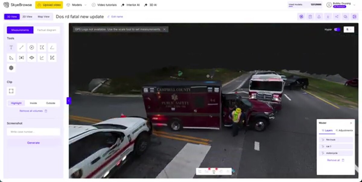
A crew member walks through a target occupancy with a phone or flies a drone orbit over a fire scene and uploads the video. Cloud processing returns a measurable 3D model that can be reviewed on any device before the next alarm. No specialized hardware. No sketch digitization step.
Arson Evidence Captured Before Scene Deterioration
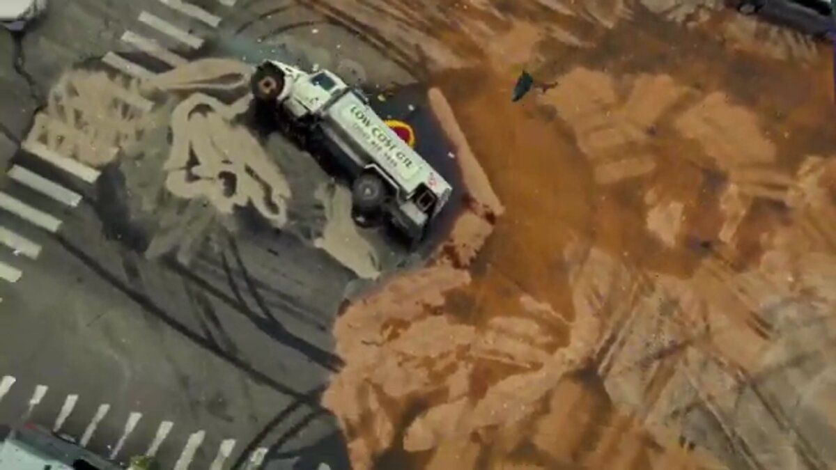
Fire scenes deteriorate faster than crash scenes — water, overhaul debris, and structural instability destroy evidence within hours of suppression. SkyeBrowse gives Roanoke fire investigators a drone capture workflow that documents origin-and-cause geometry before the scene changes further. Premium Advanced delivers post-fire measurement fidelity that supports Virginia Code arson prosecution thresholds, with the full 3D record built in roughly 10 minutes of capture time.
Roanoke's building inventory spans every era of construction. The City Market's historic brick commercials sit blocks from Carilion's modern hospital towers, which sit minutes from 1960s-era garden apartments on the Williamson Road corridor. Each construction type has different fire behavior, collapse risk, and access challenges — and each presents a different evidence-preservation timeline for investigators.
Videogrammetry makes thorough post-fire documentation feasible within the evidence window. A fire investigator or crew member captures a drone orbit of the scene, and SkyeBrowse produces a 3D model showing burn patterns, structural collapse geometry, and spatial relationships between potential origin areas. For routine pre-planning, SkyeBrowse Lite and Premium tiers provide the spatial detail crews need. The model lives on the secure cloud, accessible to every crew member on every shift.
Post-fire investigation at the Premium Advanced tier delivers forensic-grade spatial data. The platform's scene-cleanup processing strips firefighters, hose lines, and overhaul debris from the model, leaving the physical fire scene geometry that arson investigators need. That cleaned model — captured while the scene is still accessible and before further deterioration — represents the investigation evidence captured before scene deterioration, and meets the documentation standard referenced by NFPA 921 for origin-and-cause analysis.
The Carilion medical campus deserves special attention. Operating rooms, MRI suites, oxygen storage, and patient care floors all present unique fire risks. A 3D pre-plan model gives incoming crews spatial awareness of floor layout, vertical transportation, and medical gas shutoffs before they step off the apparatus — and gives investigators a pre-fire spatial record if arson is ever suspected at a facility of that scale.
Training, Hazmat Response, and Multi-Agency Coordination
SkyeBrowse models captured during hazmat responses give the incident commander an overhead spatial view with measurement capability that mutual aid partners from Roanoke County, Salem, and Botetourt County can access through a single secure cloud link. New recruits and promotion candidates also use past incident models to build spatial awareness and command decision-making skills.
Norfolk Southern's rail operations generate hazmat risk that touches every station's response area. Freight trains carrying chemicals, petroleum products, and industrial materials pass through the valley daily. A derailment or tank car breach requires spatial documentation of the hot zone, decontamination corridor, and environmental impact area that flat diagrams cannot represent.
A SkyeBrowse model captured by drone during a hazmat response gives the incident commander an overhead spatial view with measurement capability. Mutual aid partners from Roanoke County, Salem, and Botetourt County access the same model through a secure cloud link, eliminating miscommunication about distances, landmarks, and staging positions.
Training value extends beyond incident response. New recruits study 3D models of past incidents to build spatial awareness of fire behavior and tactical options. Officers preparing for promotion review incident models to develop command decision-making skills. For arson investigation training, documented cases become teaching resources that show investigators exactly what the scene looked like in the early evidence window — information that photographs alone cannot convey.
The Roanoke River corridor presents flood and swift-water rescue challenges during heavy rain events. Post-flood documentation of damaged structures and debris fields is faster with drone-based videogrammetry than with ground-level photography.
Virginia Fire Investigation Evidence Chain and NFPA 921 Standards
Roanoke Fire Department's arson investigation evidence is presented in Virginia Circuit Courts, where chain of custody and data integrity are scrutinized from capture through courtroom presentation. SkyeBrowse's CJIS-compliant audit trails and government-grade cloud hosting provide the evidentiary foundation Virginia prosecutors need — and the platform's documentation approach aligns with the systematic investigation methodology NFPA 921 requires.
A model that cannot be verified as unaltered after the fact is a liability, not an asset. SkyeBrowse addresses this directly through secure government-grade cloud hosting that automatically logs every access event, maintaining an audit trail that prosecutors can cite when establishing evidentiary foundation in Virginia Circuit Court.
NFPA 921, the authoritative guide for fire and explosion investigations, requires investigators to document the scene systematically and preserve spatial relationships between evidence items. A 3D model captured immediately after suppression and overhaul preserves that spatial record with post-fire measurement fidelity that supports Virginia Code arson prosecution thresholds — measurements that remain verifiable long after the physical scene has been demolished, remediated, or otherwise altered.
For sensitive pre-plan data — particularly models of the Carilion medical campus, which contain floor-level detail of patient care areas and critical infrastructure — controlled sharing matters as much as storage security. SkyeBrowse's permission system limits model access to authorized crew members and investigation personnel, preventing pre-plan data from becoming a security exposure for the facilities it protects.
Long-term data retention on Premium and Premium Advanced tiers keeps evidence accessible through the full appeals cycle. For arson cases that take 12 to 24 months to reach trial, and for civil litigation stemming from fire losses, that guarantee means the department's 3D documentation remains available and verifiable long after physical evidence is no longer accessible at the scene.
Investigation Timeline Compression and Prosecution Evidence Completeness
Arson prosecution evidence completeness depends on how much of the scene is captured before deterioration advances. SkyeBrowse compresses the time from suppression to documented 3D record to roughly 10 minutes of capture, ensuring that origin-and-cause geometry is preserved at its most informative state — before overhaul debris is removed, before weather degrades burn patterns, before structural instability forces investigators out of collapse zones.
Roanoke Fire Department protects a city with the building complexity of a much larger metro compressed into a valley. The City Market pre-planning backlog alone — dozens of attached historic occupancies that share structural elements requiring individual 3D documentation — could consume months of dedicated manual survey time. SkyeBrowse converts that backlog into a systematic capture project. A crew member captures one building during a non-peak period, uploads the video, and has a shareable 3D pre-plan model before the end of shift. At that pace, the entire City Market district becomes pre-planned within a defined timeline rather than remaining an indefinite future project — and each pre-plan doubles as an investigative baseline if a suspicious fire ever occurs in the district.
On active investigation scenes, the shift from extended manual documentation to rapid video capture ensures that origin-and-cause evidence is locked into the 3D record before the most volatile period of scene change passes. A fire investigator who would previously spend hours on manual measurement — hours during which the scene continues to deteriorate under weather, debris settlement, and structural movement — now completes capture in about 10 minutes and leaves the scene with a complete forensic record in the cloud.
The Williamson Road corridor's garden apartment stock — dense residential with challenging access and significant fire load — benefits from pre-planning before an event, not after. With SkyeBrowse, crews can systematically work through that corridor building by building, building a model library that provides both operational awareness for companies responding at 2 a.m. and investigative baselines for arson cases where pre-fire spatial data matters.

FAQ
How does SkyeBrowse support fire pre-incident planning for Roanoke Fire Department?
A crew member captures a walkthrough video of a target occupancy with a smartphone or drone, and SkyeBrowse produces a 3D model showing ceiling heights, structural members, standpipe connections, and exposure distances. The model is stored on the secure cloud and accessible to every crew member on every shift. For City Market's historic attached buildings — where shared cocklofts and interconnected basements make flat sketches inadequate — 3D pre-plans give incoming companies a genuine spatial picture of what they are entering, and give investigators a pre-fire baseline if arson is suspected. See SkyeBrowse tutorials for capture workflows.
Is SkyeBrowse fire investigation evidence admissible in Virginia courts?
Yes. SkyeBrowse Premium Advanced delivers post-fire measurement fidelity that supports Virginia Code arson prosecution thresholds, with CJIS-ready audit trails and scene-cleanup processing that aligns with the systematic documentation methodology required by the NFPA 921 Guide for Fire and Explosion Investigations. These controls support arson evidence presentation in Virginia Circuit Courts.
Can SkyeBrowse support multi-agency hazmat response coordination for Roanoke?
Yes. When a Norfolk Southern rail incident requires coordinated response, SkyeBrowse generates a measurable overhead 3D model that the incident commander can share with mutual aid partners via a secure cloud link. Roanoke County, Salem, and Botetourt County responders see the same hot zone boundaries, staging distances, and decontamination corridor geometry — no radio description of landmarks, no miscommunication about what "north of the tank car" means on the ground.
Get a SkyeBrowse Quote for Roanoke Fire Department
Roanoke's layered risk profile — historic commercial district, active rail corridor, wildland-urban interface, major medical campus — calls for investigation documentation that captures evidence before scene deterioration advances, and pre-incident models that keep pace with threats rather than months behind them. Contact SkyeBrowse to find out which subscription tier fits the department's mission profile and how quickly the City Market pre-planning project can begin.