Cleveland Hopkins International Airport sits less than two miles from the Middleburg Heights city limits. That proximity defines much of what this Cuyahoga County fire department of roughly 15,800 residents must prepare for: aircraft emergencies, jet fuel spills, and constant commercial and cargo operations north of the I-71 corridor. Add the Engle Road industrial district, the Southland Shopping Center drawing regional retail traffic, and postwar housing stock with aging electrical systems, and Middleburg Heights Fire Department faces a hazard profile rivaling departments three times its size.
Documentation has always been the bottleneck — and fire investigation reporting has historically been the most time-intensive piece. SkyeBrowse changes that equation by converting a single video capture into a measurable 3D model that anchors the investigation report in verified spatial data from the start.
Key Takeaways
- A crew member with a smartphone can pre-plan an Engle Road industrial occupancy in about 20 minutes, replacing a slow walkthrough-and-sketch backlog that grows stale before it is completed.
- 3D fire scene documentation captured before overhaul operations begin gives investigators the verified measurements needed to complete NFIRS module entries without field-estimate ambiguity.
- Fire scene measurement precision satisfies Ohio Division of State Fire Marshal reporting requirements and the NFPA 921 documentation standard for origin-and-cause methodology.
- Drone-captured 3D models of I-71 corridor hazmat scenes give the incident commander spatial context on hot zones and decon corridors before mutual aid units from Berea, Brook Park, and Parma arrive on scene.
- Hopkins Airport adjacency means crews respond to unfamiliar structures under extreme time pressure — pre-plan models of hangars, terminals, and fuel storage areas give arriving crews spatial orientation before they step off the apparatus.
Contents
- Why Middleburg Heights Fire Department Chose Videogrammetry
- Pre-Incident Planning and Post-Fire Documentation
- How 3D Models Change NFIRS Report Quality and Completion Time
- Training, Hazmat Response, and Multi-Agency Coordination
- FAQ
Why Middleburg Heights Fire Department Chose Videogrammetry
Middleburg Heights Fire Department adopted SkyeBrowse to replace slow manual documentation workflows that could not keep pace with the department's hazard profile — which includes airport emergencies, industrial corridor risks, and I-71 corridor incidents. Processing at a 1:1 ratio means completed 3D models are available minutes after capture, giving investigators spatial data before overhaul alters the scene and before NFIRS reporting deadlines close in.
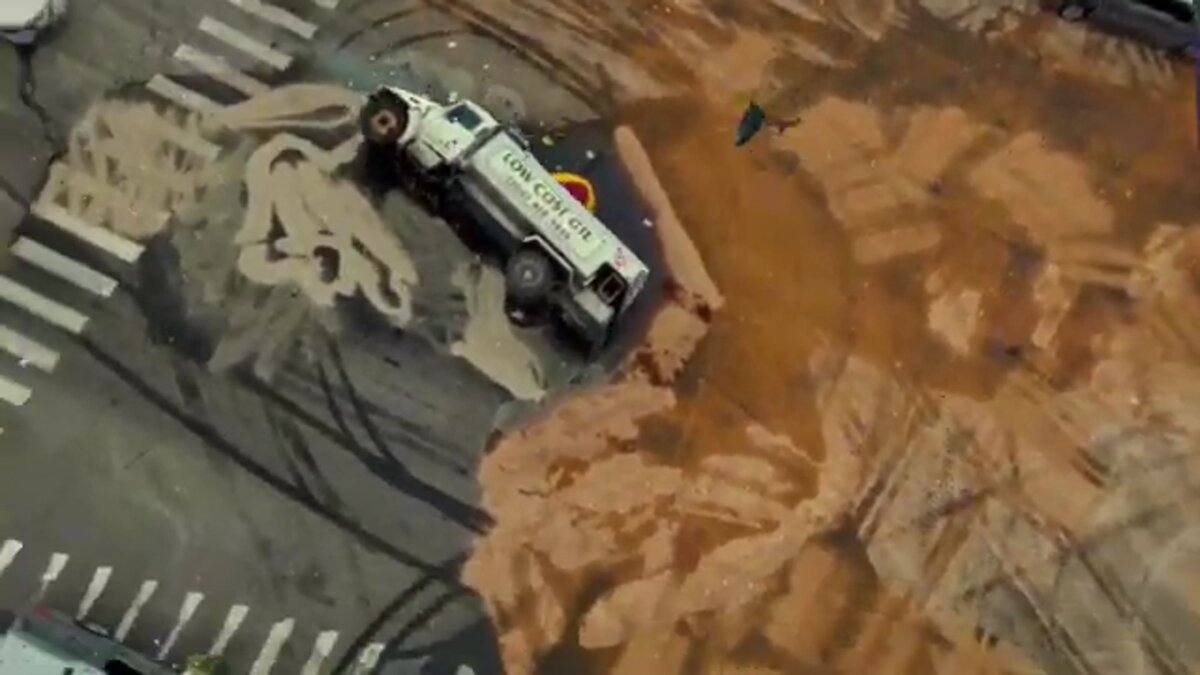
The I-71 corridor through Middleburg Heights carries heavy traffic between Cleveland's southwest suburbs and Akron-Canton. Multi-vehicle crashes, commercial vehicle rollovers, and hazmat spills on the interstate demand documentation that captures vehicle positions, debris fields, and road geometry quickly enough to reopen lanes before secondary incidents compound the problem.
Off the highway, the Engle Road industrial corridor presents fire risks that residential-only departments never face. Warehouses with high-piled stock, chemical storage facilities, and manufacturing operations with process hazards all require pre-incident plans that go beyond a set of floor-plan sketches pinned to a clipboard. Traditional walkthrough documentation falls behind occupancy changes, renovation permits, and tenant turnover — the pre-plan that was accurate eighteen months ago may describe a building that no longer exists.
Mutual aid calls to Hopkins Airport mean crews must understand unfamiliar structures and tarmac layouts under extreme time pressure. Pre-plan models of hangars, terminals, and fuel storage areas give responding crews spatial context before they arrive on scene. SkyeBrowse ingests .MP4 and .MOV files from smartphones, drones already in the department's inventory, body-worn cameras, and 360 cameras — no dedicated hardware purchase required.
Pre-Incident Planning and Post-Fire Documentation
SkyeBrowse enables a crew member to pre-plan an entire building in 20 minutes with a smartphone, producing a cloud-accessible 3D model that captures ceiling heights, column spacing, and fire protection equipment locations. For post-fire investigation, the platform's Premium Advanced tier preserves burn patterns and evidence locations at the spatial resolution NFPA 921 methodology requires — before overhaul operations alter the scene geometry.
Middleburg Heights' commercial building stock includes strip malls, standalone retail, light industrial, and older office parks. Each occupancy type has different fire behavior characteristics, and pre-planning all of them with traditional walkthrough-and-sketch methods is a multi-year project that starts going stale before it is finished.
A crew member with a smartphone can walk a building in 20 minutes and produce a 3D model that captures ceiling heights, column spacing, fire protection equipment locations, and exposure distances. For routine pre-planning, SkyeBrowse Lite and Premium tiers (Premium delivers 8K resolution with 0.25 inch accuracy) provide the spatial detail crews need. That model lives on SkyeBrowse's secure cloud, accessible to every crew member on every apparatus.
Post-fire investigation in Ohio requires thorough origin-and-cause documentation aligned with NFPA 921 methodology. SkyeBrowse Premium Advanced captures burn patterns, structural collapse geometry, and evidence locations before overhaul operations alter the scene. The resulting forensic model preserves spatial relationships between ignition sources, fire extension paths, and structural features that photographs flatten — creating the evidentiary foundation investigators need before reconstruction begins.
Residential fires in the city's postwar housing stock often involve balloon-frame construction, knob-and-tube wiring, and retrofitted HVAC systems that complicate origin determination. A 3D model preserves exactly the spatial context that NFPA 921's systematic investigation methodology depends on.
How 3D Models Change NFIRS Report Quality and Completion Time {#how-3d-models-change-nfirs-report-quality}
Ohio fire departments file investigation reports with the Ohio Division of State Fire Marshal through the National Fire Incident Reporting System. NFIRS fire investigation modules require specific cause-and-origin data, equipment involvement codes, and property use classifications that are difficult to complete accurately without verified spatial documentation. A SkyeBrowse model captured before overhaul gives investigators precise measurements to support every data field — reducing both the time to complete the report and the likelihood of a rejection for insufficient documentation.
Fire investigation reporting is where documentation quality has the most immediate operational consequence. An NFIRS report filed with field estimates instead of verified measurements can trigger follow-up requests from the Ohio Division of State Fire Marshal, delay insurance subrogation, and weaken the evidentiary record if the case escalates to arson prosecution in the Ohio Court of Common Pleas.
A 3D model captured in the minutes immediately after suppression gives the investigator verified burn pattern geometry, structural collapse measurements, and spatial relationships between ignition sources and fire extension paths. The investigator completes the NFIRS fire investigation module — including area of origin, heat source, and fire spread entries — using measured distances rather than visual estimates. Report completion time drops because investigators are not returning to the scene for additional measurements or reconstructing spatial relationships from photographs taken after overhaul has destroyed the geometry.
The same spatial record supports the department's ISO Public Protection Classification documentation. Consistent, verifiable investigation records improve the quality of data submitted during ISO surveys, which affects the fire risk ratings that influence property insurance costs across the city. Fire scene measurement precision that satisfies Ohio Division of State Fire Marshal reporting requirements also strengthens the department's long-term documentation posture across both routine fires and complex arson investigations.
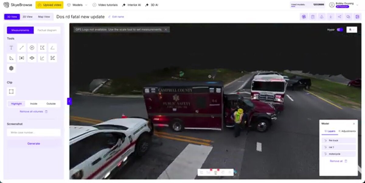
For arson cases, the forensic model meets the evidence documentation standard for proceedings in the Cuyahoga County Court of Common Pleas. Every model is accompanied by a time-stamped audit log that records every access event from initial upload through courtroom presentation, supporting chain-of-custody requirements under Ohio evidence rules. The controlled-sharing feature lets the fire investigation unit grant read-only access to the Cuyahoga County prosecutor, insurance adjusters, and ATF investigators without releasing editing permissions.
Training, Hazmat Response, and Multi-Agency Coordination
SkyeBrowse gives Middleburg Heights Fire Department a shared 3D model that mutual aid partners from Berea, Brook Park, and Parma access simultaneously through a secure cloud link, eliminating confusion about building layout and staging areas. Drone-captured models of hazmat scenes provide incident commanders a top-down spatial view of hot zones, decontamination corridors, and evacuation perimeters that static photos cannot convey.
The Engle Road industrial district and I-71 corridor both generate hazmat risk. Chemical spills, fuel tanker incidents, and warehouse fires involving unknown contents require spatial documentation of hot zones, decontamination corridors, and evacuation perimeters. A SkyeBrowse model captured by drone gives the incident commander a top-down spatial view that static photos and hand-drawn sketches cannot provide.
Mutual aid with neighboring Berea, Brook Park, and Parma fire departments is routine. When multiple agencies converge, a shared 3D model eliminates confusion about building layout, hydrant locations, and staging areas. Every partner accesses the same data through SkyeBrowse's secure cloud link. Command staff can brief incoming units on scene geometry before those crews step off the apparatus — a capability that matters enormously when the responding mutual aid officer has never been inside that particular warehouse or chemical storage facility.
Training scenarios on the drill grounds can be captured before and after live-fire evolutions, creating a permanent spatial record for after-action reviews and new-member orientation. Probationary firefighters studying an unfamiliar occupancy type can walk the 3D model from the station rather than waiting for a scheduled building tour.
FAQ
How does SkyeBrowse accelerate pre-incident planning for Engle Road industrial occupancies?
A crew member walks the target facility with a smartphone, recording a continuous video of the layout, ceiling heights, column spacing, and fire protection equipment. SkyeBrowse converts that footage into a cloud-hosted 3D model accessible to every apparatus in the fleet, turning what was a multi-year sketch-and-walkthrough backlog into a manageable building-by-building project. Learn more at skyebrowse.com/tutorials.
How does SkyeBrowse improve NFIRS report quality for Middleburg Heights fire investigations?
A 3D model captured before overhaul operations begin gives the fire investigator precise burn pattern geometry, structural collapse measurements, and spatial relationships between ignition sources and fire extension paths. That spatial record eliminates the ambiguity that slows origin-and-cause determination and allows investigators to complete NFIRS module entries with verified measurements, satisfying Ohio Division of State Fire Marshal reporting requirements.
How does SkyeBrowse help Middleburg Heights coordinate mutual aid during I-71 hazmat incidents?
A drone-captured SkyeBrowse model gives the incident commander a top-down spatial view of hot zones, decontamination corridors, and evacuation perimeters within minutes of scene arrival. Mutual aid units from Berea, Brook Park, and Parma receive a shared cloud link to that same model, so every agency works from identical spatial data rather than radio descriptions of an unfamiliar scene. See supported drones at skyebrowse.com/supported-drones.
Get a SkyeBrowse Quote for Middleburg Heights Fire Department
Middleburg Heights Fire Department carries a hazard load that most suburban departments never see — airport adjacency, an active industrial corridor, and I-71 highway incidents — all on a staffing model built for a city of 15,800. SkyeBrowse gives every crew member the documentation capability that directly improves investigation report quality, reduces NFIRS filing time, and meets Ohio Division of State Fire Marshal standards on every fire scene.