Ask a Middletown detective how many hours disappear preparing crash testimony for Connecticut Superior Court and the answer reveals a hidden cost that never shows up in overtime reports. Static photographs require explanation. Diagrams require measurement verification. Expert witnesses require orientation walkthroughs on paper exhibits. A navigable 3D model of the scene — one that prosecutors, defense counsel, and jurors can all move through independently — compresses that pre-trial preparation from hours into minutes. That is the operational calculus that drove Middletown PD's adoption of SkyeBrowse, a platform that converts drone video into court-ready 3D documentation while the scene is still secured.
Middletown is a mid-sized New England city of roughly 47,700 residents where Route 9 expressway slices through the eastern half, carrying commuters between Hartford and the shoreline at speeds that generate high-severity crashes on its limited-access ramps. Historic Main Street, Middlesex Hospital, and Wesleyan University create pedestrian-dense zones where every collision demands documentation precise enough to survive Middlesex Judicial District scrutiny.
Key Takeaways
- Route 9's limited-access ramps have no practical alternate route through Middletown; a single crash there backs traffic past Middlesex Hospital — SkyeBrowse clears those scenes before ambulance access is compromised.
- Steep Connecticut River grades and narrow historic intersections near Main Street produce terrain changes that SkyeBrowse's 3D geometry captures accurately, unlike flat-plane diagrams.
- Premium Advanced models carry geometric precision that satisfies Connecticut court Daubert standards, giving the Middlesex State's Attorney's office interactive exhibits that hold up against defense expert challenge.
- Detectives preparing felony traffic testimony report that a navigable 3D model replaces multiple rounds of photo review, diagram annotation, and expert orientation — reducing hours of pre-trial preparation per case.
- Officers upload footage from drones and smartphones already in their kit — no new scanner purchase required, and no reconstruction specialist on call.
Contents
- Why Middletown Police Department Chose Videogrammetry
- Accident and Crime Scene Documentation
- CJIS-Compliant 3D Evidence for Connecticut Courts
- Case Throughput and Courtroom Preparation
- FAQ
Why Middletown Police Department Chose Videogrammetry
Route 9 on-ramps and off-ramps feed directly into Middletown's surface street network, producing frequent high-severity collisions where traditional reconstruction consumed officer hours that compounded long after the scene cleared. The same footage needed to clear the road becomes the exhibit that resolves the case in court — one capture, two problems solved.
Route 9 on-ramps and off-ramps feed directly into Middletown's surface street network, and speed differentials between expressway traffic and local turns cause frequent rear-end and angle collisions. The I-91 interchange northwest of the city funnels additional regional traffic through Washington Street and Route 66, creating secondary collision hotspots.
Traditional reconstruction methods demanded extensive scene time on roads that serve as the only practical routes between Middletown's residential neighborhoods and commercial districts. The resulting traffic backups stacked past Middlesex Hospital, delaying ambulance access. And the hours invested at the scene were only the beginning — detectives then spent additional preparation time converting photographs and hand measurements into courtroom exhibits.
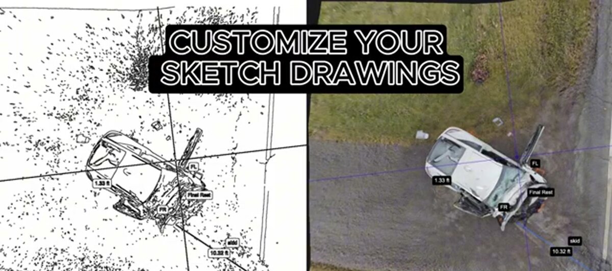
SkyeBrowse eliminates that bottleneck at both ends. One officer captures continuous video with a drone orbit or smartphone walk. The measurable 3D model is ready while the scene is still secured, with geometry accurate enough to support crash reconstruction testimony — and precise enough that the same model serves as the courtroom exhibit without separate preparation work.
Middletown PD integrated SkyeBrowse using equipment already in its inventory, requiring no new procurement cycle.
Accident and Crime Scene Documentation
Middletown's narrow intersections, steep river grades, and winter road conditions compress the window for preserving physical evidence. SkyeBrowse captures the full roadway geometry, vehicle orientations, and evidence positions in about 10 minutes, creating a permanent 3D record investigators can review remotely without a return visit.
Middletown's road network reflects its age. Narrow intersections near Main Street, steep grades descending to the Connecticut River, and blind curves on residential roads near Wesleyan's campus all create challenging documentation environments. Winter ice and snowbanks further complicate scene access and compress the window for preserving tire marks and debris positions.
SkyeBrowse captures these scenes in about 10 minutes. The 3D model records the full roadway geometry, vehicle orientations, traffic-control devices, and evidence positions so investigators reconstruct events without a return visit — even after plows have cleared the road.
Crime scene documentation benefits from the same approach. A shooting near the university or a vehicle pursuit ending on Route 66 produces a spatial record that detectives review remotely. Cloud-based sharing supports simultaneous access for Middletown investigators, state police, and the Middlesex State's Attorney's office — with each reviewer navigating the same model from their own desk instead of scheduling a joint scene walkthrough.
The Connecticut River waterfront adds another dimension. Scenes near the riverbank involve grade changes, retaining walls, and limited vehicle access. A drone orbit captures terrain that manual measurement teams cannot efficiently reach on foot.

CJIS-Compliant 3D Evidence for Connecticut Courts
Connecticut Superior Court's Daubert standard requires demonstrative evidence to rest on reliable methodology with documented provenance. SkyeBrowse Premium Advanced produces models at geometric precision that satisfies Connecticut court Daubert standards, backed by CJIS-compliant infrastructure and an immutable chain-of-custody record that the Middlesex Judicial District can examine from capture to verdict.
The Middlesex Judicial District processes Middletown's felony traffic and criminal cases through Connecticut Superior Court, where prosecutors must present evidence that holds up against defense experts who specialize in picking apart reconstruction methodology. Connecticut's Daubert framework requires that expert testimony rest on reliable scientific methods — and the documented accuracy of SkyeBrowse's photogrammetric process, combined with its immutable audit log, satisfies that threshold.
SkyeBrowse Premium Advanced delivers sub-inch spatial accuracy with an automated object-removal step that strips bystanders and emergency vehicles from the scene geometry, so what prosecutors receive reflects conditions at the moment of the incident. Every access event from initial upload through court presentation is logged in an audit trail stored on CJIS-compliant cloud infrastructure — not in a separate tracking system — making it straightforward to produce in discovery without manual reconstruction of the chain of custody.
The Middlesex State's Attorney's office can review shared models directly in the browser, and a controlled sharing link carries its own access log. GLB models give prosecutors an interactive 3D exhibit that a jury can navigate during deliberations. LAZ point clouds go to defense and prosecution reconstruction experts who want to run their own measurements. Both export from the same model file the officer uploaded at the scene — no separate deliverable preparation required.
For cases requiring extended archival, the platform's long-term data retention on Premium and Premium Advanced tiers means evidence remains available through appeals, not just through trial.
Case Throughput and Courtroom Preparation
The downstream payoff of a navigable 3D model is measured in hours of detective and prosecutor time recovered per case. Where static photographs required annotation sessions, expert walkthroughs, and diagram revisions, a shareable 3D model lets every party orient independently — compressing pre-trial preparation and freeing investigative capacity for the next case in the queue.
Middletown PD covers a diverse jurisdiction that includes a university, a regional hospital, an expressway corridor, and a historic downtown. The resource math of multi-officer, multi-hour documentation played out badly every time: Route 9 backed up, ambulance routes to Middlesex Hospital tightened, and patrol coverage thinned across every other sector. With SkyeBrowse, the responding officer handles the scene while the rest of the shift stays in service.
The courtroom efficiency compounds that field savings. Detectives preparing testimony for felony traffic trials report that a navigable 3D model reduces pre-trial preparation time meaningfully per case — orientation sessions with prosecutors are shorter, exhibit preparation requires fewer revision cycles, and defense experts challenging the data can be sent a shared link rather than requiring a joint session. That recovered time flows back into the active case queue.
Supervisors also gain consistency: because the capture workflow is standardized, a newer officer with a department drone produces a model that meets the same evidentiary standard as one produced by a ten-year veteran reconstructionist. The department's documentation quality no longer depends on which officer happened to draw the scene.
FAQ
How does SkyeBrowse handle crash documentation on Route 9 ramps in Middletown?
Route 9's limited-access ramps have no practical alternate route through Middletown, and a collision there closes lanes that back traffic past Middlesex Hospital within minutes. SkyeBrowse lets one officer fly a drone orbit and get a measured 3D model back in roughly 10 minutes — fast enough to clear the ramp before the backup reaches the hospital access road. Learn more at skyebrowse.com/tutorials.
Can SkyeBrowse evidence meet Connecticut Superior Court standards for the Middlesex Judicial District?
Yes. Connecticut Superior Court's Daubert framework requires that reconstruction evidence rest on reliable, documented methodology. SkyeBrowse Premium Advanced models carry sub-inch geometric accuracy with a CJIS-compliant audit trail that records every access event from capture through verdict. Defense experts challenging measurement precision in Middlesex Superior Court access the same navigable model the prosecution uses — there is no separate exhibit to dispute. See skyebrowse.com/pricing-premium for tier details.
Does SkyeBrowse work for winter crash scenes on Middletown's steep river grades?
Yes. A drone orbit captures the full three-dimensional scene geometry — including grades descending to the Connecticut River — in a single pass before plows alter the road surface. The permanent model preserves skid mark length, debris scatter, and elevation transitions that would be impossible to re-measure after ice removal.
Get a SkyeBrowse Quote for Middletown Police Department
Middletown's Route 9 corridor demands faster scene clearance than traditional reconstruction can deliver, and Middlesex Superior Court demands evidence precision that pen-and-tape methods cannot match. SkyeBrowse solves both problems with existing patrol equipment. Contact us to see the platform with Middletown-specific scenarios.