The measure of a fire department's pre-planning program is not how many buildings are on the list — it is how many are actually documented before the first call comes in. Hamilton County, Indiana has been adding commercial occupancies faster than any traditional pre-plan survey schedule could track. New subdivisions along the SR-37 corridor, big-box clusters at Hamilton Town Center, and multi-story hotel properties have all opened in recent years, each representing a structure the department needed to understand before responding blind. Noblesville Fire Department adopted SkyeBrowse to close that gap — converting a crew member's smartphone walkthrough into a dimensionally accurate, cloud-accessible 3D model that every apparatus can reach before the building's first tenant arrives.
The department now documents multiple new commercial structures per month with existing crew and equipment, compared to the handful that legacy survey methods could realistically cover in the same period. That shift in documentation capacity is the story this article tells.
Key Takeaways
- Hamilton County's commercial development pace was outrunning the department's pre-plan backlog; SkyeBrowse lets crews document new occupancies at the rate they open rather than months after tenants arrive.
- A trained crew member can complete a commercial walkthrough, submit the video, and have a finished 3D model on apparatus tablets the same day — ceiling heights, column spacing, FDC locations, and sprinkler configurations all measurable.
- Origin-and-cause investigations in Hamilton County Circuit Court benefit from documentation accuracy that exceeds NFPA 921 recommended practice for fire scene measurement, giving fire investigators spatial evidence that withstands defense scrutiny in arson proceedings.
- Hamilton Town Center's mix of big-box retail, multi-story hotels, and a multiplex cinema creates pre-plan complexity that smartphone-captured 3D models resolve faster than any paper floor-plan library.
- Mutual aid partners from Fishers, Carmel, and Westfield access the same 3D scene model through a single secure cloud link — no physical handoff of drawings, no re-measurement by neighboring crews.
Contents
- Why Noblesville Fire Department Chose Videogrammetry
- Pre-Incident Planning and Post-Fire Documentation
- Training, Hazmat Response, and Multi-Agency Coordination
- Compliance and Data Security for Indiana
- Pre-Planning Coverage and Inspection Capacity
- FAQ
Why Noblesville Fire Department Chose Videogrammetry
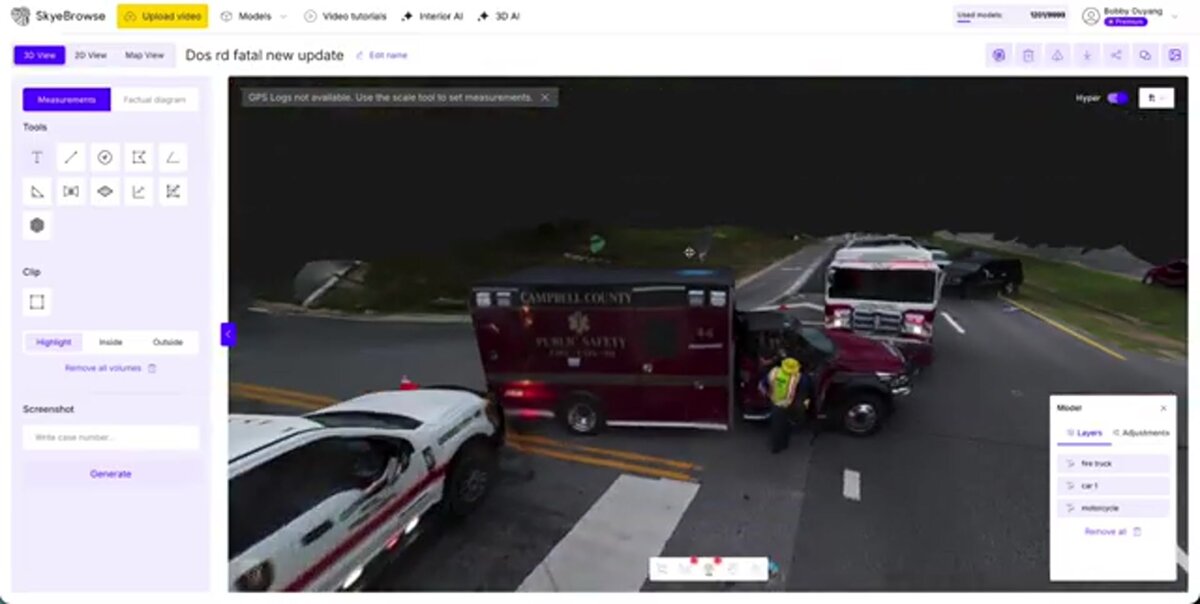
Growth creates a documentation debt that traditional methods cannot repay at scale. Every apartment complex, retail strip, and distribution warehouse that opens along Noblesville's SR-37 corridor needs a pre-incident plan before the first tenant moves in. A crew member shoots a continuous walkthrough video on a smartphone or drone; SkyeBrowse converts that footage into a finished 3D model — ceiling heights, column spacing, FDC locations, all measurable — before the occupancy certificate clears the city's building department.
The White River corridor adds flood and water-rescue risk. Seasonal flooding affects riverside homes, parks, and bridge approaches, and post-flood damage documentation must happen quickly before water recedes and conditions change.
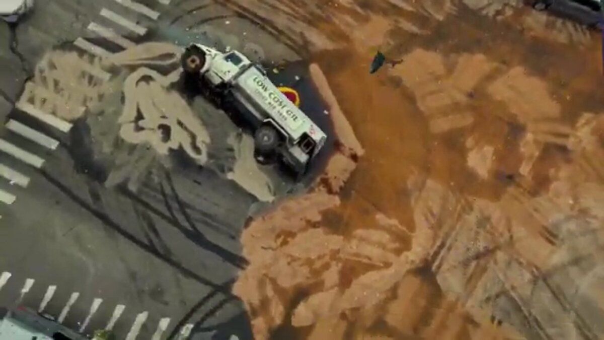
The SR-37 corridor conversion from a surface highway to a limited-access freeway has created years of construction-zone incidents. Vehicle extrications in active work zones require documentation that captures barrier placement, lane configurations, and equipment positions — scene geometry that a drone orbit resolves in a single pass without tying up additional crew members.
Historic downtown Noblesville includes older commercial buildings with party-wall construction, shared cocklofts, and limited standpipe coverage. These structures present fire extension risks that modern buildings do not, and pre-plan models capture those structural hazards in spatial detail that floor plans miss.
Pre-Incident Planning and Post-Fire Documentation
Noblesville's commercial building inventory is expanding faster than the department can pre-plan it with legacy methods. A crew member walks a new Hamilton Town Center occupancy with a smartphone; SkyeBrowse builds a 3D model showing ceiling heights, column spacing, fire department connections, standpipe locations, and exposure distances — stored on secure cloud infrastructure and accessible on every apparatus tablet before the building opens. When a fire does occur, Premium Advanced's documentation accuracy that exceeds NFPA 921 recommended practice for fire scene measurement captures burn patterns, collapse geometry, and evidence positions before overhaul operations alter the scene.
Hamilton Town Center alone includes big-box retail, restaurants, a multiplex cinema, and multi-story hotel properties. Each occupancy has different fire load characteristics, sprinkler system configurations, and access challenges. For routine pre-planning, SkyeBrowse Premium (8K resolution, 0.25 inch accuracy) provides the spatial detail crews need. The model is stored on SkyeBrowse's secure cloud, accessible to every crew member on every apparatus.
An automated object-removal step produces a forensically clean model for investigators and prosecutors, eliminating the risk that a bystander or emergency vehicle in the footage contaminates the evidentiary record.
Historic downtown Noblesville includes older commercial buildings with party-wall construction, shared cocklofts, and limited standpipe coverage. Pre-plan models capture those risks in spatial detail that floor plans miss.
Training, Hazmat Response, and Multi-Agency Coordination
Ruoff Music Center events present mass-gathering risks that require coordinated response planning with Hamilton County EMA, Noblesville PD, and mutual aid fire departments from Fishers, Carmel, and Westfield. A 3D model of the venue and surrounding access roads gives every agency the same spatial reference for staging, triage, and evacuation routes. SkyeBrowse's cloud sharing ensures every mutual aid partner sees the same scene data through one secure link.
The SR-37 corridor and active rail lines through the city create hazmat exposure. Fuel tanker incidents, construction chemical spills, and rail car derailments all require spatial documentation of hot zones and decontamination corridors that flat sketches cannot adequately represent.
Training new firefighters on building construction types is more effective with 3D models. Recruits study the differences between lightweight truss construction in new subdivisions and the heavy timber frames of downtown buildings without scheduling visits to every target hazard. Officers preparing for promotional exams review past incident models to sharpen tactical decision-making.
Compliance and Data Security for Indiana
Indiana fire investigation evidence standards and NFPA 921 guidance both require that origin-and-cause documentation rest on defensible measurement methodology with documented provenance. SkyeBrowse Premium Advanced delivers documentation accuracy that exceeds NFPA 921 recommended practice for fire scene measurement, hosted on CJIS-compliant infrastructure that maintains an unbroken chain-of-custody record from the moment a crew member hits record through years of post-trial archival.
For Noblesville Fire Department, the chain-of-custody requirements extend beyond what standard cloud storage provides. Indiana fire investigation evidence standards require that origin-and-cause documentation withstand challenge in Hamilton County Circuit Court — where arson and negligent-fire cases demand spatial measurements that can be independently verified. NFPA 921, the authoritative guide for fire and explosion investigations, recommends systematic documentation with measurable accuracy, and SkyeBrowse's Premium Advanced tier meets that bar.
CJIS-ready workflows enforce audit trails on every model — who accessed it, when, and from which device — so investigators can testify to data integrity without relying on verbal attestation. The automated object-removal step strips bystanders and emergency vehicles from the captured scene, producing a forensically clean model that prosecutors and defense experts work from the same unaltered record.
Sensitive fire investigation files, including origin-and-cause documentation for ongoing criminal cases, stay under controlled sharing rules. Only designated personnel can export or share models, and long-term guaranteed data retention on Premium and Premium Advanced tiers means Hamilton County Circuit Court can subpoena records years after an incident closes without risk of the evidence having been purged.
Pre-Planning Coverage and Inspection Capacity
The clearest measure of SkyeBrowse's impact on Noblesville Fire Department is not time saved per incident — it is structures documented per month. Where traditional survey methods could realistically cover a handful of new occupancies per quarter, the department now keeps pace with Hamilton County's construction calendar, completing pre-plans as buildings receive their certificates of occupancy rather than months into the tenants' first lease year.
Consider a routine commercial pre-plan on the Hamilton Town Center campus. Under a traditional approach, two or three firefighters spend a morning measuring room dimensions, sketching floor layouts, and photographing key features before producing a hand-annotated drawing that goes into a binder. With SkyeBrowse, one crew member walks the occupancy with a smartphone and submits the video. By the time that crew is back in service, the platform has produced a dimensionally accurate, measurable 3D model available to every apparatus in the fleet.
The capacity shift is significant. A department that could previously complete a few detailed pre-plans per quarter can now document multiple commercial structures per month — keeping the pre-plan library current with Hamilton County's building permit pace rather than chasing a growing backlog. Each model is stored in the cloud and searchable by address, so incoming crews and mutual aid partners from Fishers, Carmel, and Westfield can pull a pre-plan before they arrive on scene rather than reading a paper binder in the cab.
For post-fire investigation, the efficiency difference compounds. Documentation that previously required a multi-person team, specialized survey equipment, and a multi-hour scene commitment now runs with the assigned investigator and existing hardware. Those recovered resources flow back into the pre-plan backlog that Noblesville's construction pace keeps generating.

FAQ
How does Noblesville Fire Department use 3D models to stay ahead of commercial development on SR-37?
As each new occupancy along the SR-37 corridor receives its building permit, a crew member captures a walkthrough video and submits it to SkyeBrowse. The resulting 3D model — showing ceiling heights, column spacing, sprinkler layouts, and FDC locations — is added to the department's cloud library and accessible on apparatus tablets. The pre-plan is ready before tenants move in, rather than months after occupancy when scheduling a traditional survey becomes harder. See skyebrowse.com/tutorials for capture workflows.
What makes SkyeBrowse output admissible in Hamilton County Circuit Court arson cases?
Premium Advanced models are produced at documentation accuracy that exceeds NFPA 921 recommended practice for fire scene measurement, with automated object removal that eliminates evidentiary contamination from bystanders or vehicles in the footage. The platform's CJIS-ready audit trail documents every access event, giving prosecutors a defensible chain of custody that satisfies Indiana fire investigation evidence standards from capture through courtroom presentation. See skyebrowse.com/pricing-premium for tier specifications.
How does White River flood documentation work with SkyeBrowse?
A drone orbit over flood-affected riverside areas captures spatial data that traditional ground measurement cannot safely or quickly replicate when water is still moving. SkyeBrowse processes the footage into a 3D model that documents flood extent, damage to structures and infrastructure, and changed conditions along bridge approaches. GLB models allow emergency management partners and Hamilton County EMA to review the same spatial record without traveling to the site. Documentation is complete before the water fully recedes and evidence of flood extent disappears.