Squeezed between the roar of LAX flight paths overhead and the crash of Pacific surf below, Manhattan Beach occupies a narrow strip of South Bay coastline in Los Angeles County. The city's roughly 35,500 residents share their streets with beach visitors, airport-area commuters, and Rosecrans Avenue commercial traffic. When a serious crash happens on Highland Avenue or Sepulveda Boulevard, the department faces a challenge most agencies do not: every minute of road closure is visible to an affluent, media-connected community that expects both thorough documentation and a fast return to normal.
Manhattan Beach PD adopted SkyeBrowse — a videogrammetry platform that converts continuous video into measurable 3D maps — to close scenes quickly without trading away the forensic quality that high-profile South Bay litigation demands.
Key Takeaways
- Collisions on Highland Avenue and Sepulveda create immediate public and media visibility — one officer documents the complete scene in 10 minutes, allowing rapid clearance before extended closures generate community complaints.
- The resulting 3D model gives the department a precise spatial record for press briefings, allowing public information officers to respond to media with factual geometry rather than preliminary estimates.
- Near the pier, where a standard measurement team physically cannot set up without blocking the only access lane, a handheld video walk captures the complete scene without an extended road closure.
- Premium Advanced delivers measurement fidelity that defense counsel in high-value South Bay civil cases cannot credibly challenge — satisfying LA County Superior Court evidentiary standards for contested reconstruction hearings.
- Existing department equipment — drones, phones, body cameras — uploads directly to SkyeBrowse, with no new hardware purchases required.
Contents
- Why Manhattan Beach Police Department Chose Videogrammetry
- Accident and Crime Scene Documentation
- CJIS-Compliant 3D Evidence for California Courts
- Community Confidence Through High-Visibility Scene Management
- FAQ
Why Manhattan Beach Police Department Chose Videogrammetry
Manhattan Beach PD adopted SkyeBrowse because the traditional multi-officer tape measurement approach was incompatible with a high-profile community where extended road closures become news. The platform processes a single officer's video into a measurable 3D model before that officer returns to their vehicle, and it accepts footage from equipment the department already owns — no separate procurement needed.
Manhattan Beach is small but operationally demanding. Sepulveda Boulevard carries traffic from LAX and the surrounding aerospace corridor through the center of the city. Collisions at the Sepulveda-Rosecrans intersection involve high approach speeds and complex turn geometry. The Manhattan Beach Pier area generates pedestrian incidents where detailed spatial documentation of crosswalks, curb cuts, and bollard positions can determine case outcomes.
Here the stakes are compounded by community dynamics. Committing multiple officers to a single reconstruction for hours creates gaps in coverage that residents in this affluent jurisdiction notice immediately — and report. A department this size cannot absorb that absence without generating exactly the visibility problem a community at this price point will escalate through city council or local media.
SkyeBrowse collapses that trade-off. One officer captures the scene on video — drone orbit, handheld walk, or body camera — and uploads the file to app.skyebrowse.com. Processing delivers a spatially accurate 3D model at the same speed the footage was recorded. The remaining officers stay in service.
Accident and Crime Scene Documentation
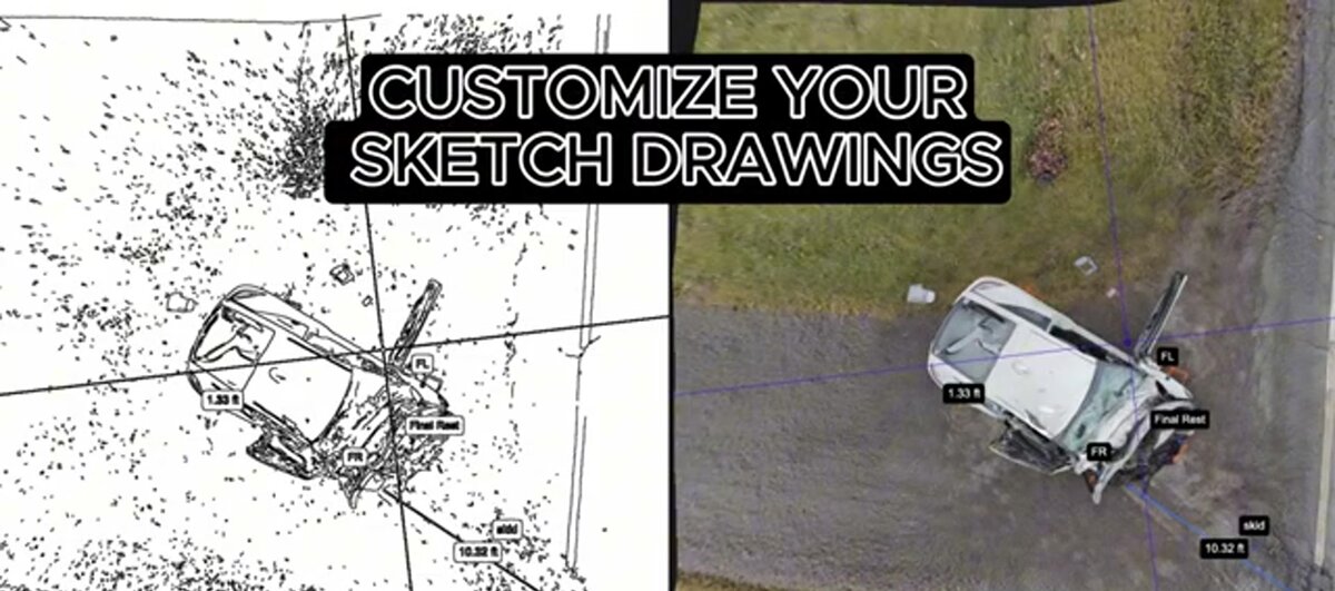
SkyeBrowse documents Manhattan Beach accident and crime scenes in about 10 minutes, preserving vehicle positions, pedestrian infrastructure, and street furniture in a measurable 3D model. Detectives, prosecutors, and expert witnesses access the same cloud-based model simultaneously, eliminating the need for return visits or physical walk-throughs.
Rosecrans Avenue serves as the primary east-west corridor connecting Manhattan Beach to neighboring Hawthorne and Lawndale. Collisions on Rosecrans often involve vehicles turning into commercial driveways where sightlines are limited by parked cars and landscaping. The 3D model captures those obstructions, giving analysts geometry that static photographs cannot convey.
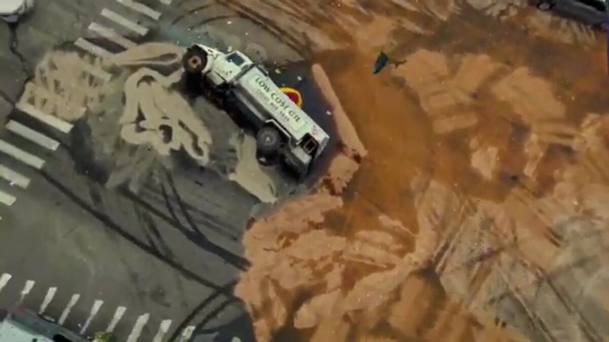
Near the pier, narrow streets and angled parking create incident scenes where traditional measurement teams physically cannot set up without blocking the only access lane. A drone orbit or handheld video walk captures the full scene context without requiring road closures that extend beyond the immediate incident area.
One officer documents these scenes in about 10 minutes. The model preserves vehicle positions, pedestrian infrastructure, lamp post locations, and street furniture so investigators measure and verify later without returning.
Residential break-in clusters, DUI arrest scenes with vehicle damage, and beach-adjacent altercations all produce a complete spatial record. Cloud-based access lets detectives, prosecutors, and expert witnesses review the same model simultaneously, with no scheduling of physical visits required.

CJIS-Compliant 3D Evidence for California Courts
SkyeBrowse Premium Advanced delivers measurement fidelity that defense counsel in high-value South Bay cases cannot credibly challenge, and protects evidence on AWS GovCloud (US) with FedRAMP Moderate alignment and CJIS-ready workflows. These capabilities allow Manhattan Beach PD evidence to withstand the aggressive expert cross-examination that characterizes high-profile civil and criminal proceedings in Los Angeles County Superior Court.
Manhattan Beach cases move through the Los Angeles County Superior Court system, where evidentiary standards demand accuracy, auditability, and reproducibility. Civil litigation connected to serious pier-area and Sepulveda corridor incidents frequently attracts experienced defense attorneys who specialize in challenging digital evidence. SkyeBrowse Premium Advanced produces forensic-grade models with the measurement fidelity that defense counsel in high-value South Bay cases cannot credibly challenge.
Security for LA County proceedings works differently than for rural jurisdictions. Defense attorneys in high-profile cases frequently challenge chain of custody for digital evidence, looking for gaps between field capture and courtroom presentation. SkyeBrowse closes those gaps structurally: data written to AWS GovCloud (US) at upload cannot be altered without generating an audit log entry, and role-based access controls mean only authorized personnel touch the model before it reaches the prosecutor or expert witness.
The retention period built into Premium and Premium Advanced tiers is particularly relevant for Manhattan Beach, where civil litigation connected to pier-area and Sepulveda corridor incidents can extend well beyond criminal case resolution. GLB format gives juries an interactive view of the scene's spatial relationships. Point cloud data in LAZ format supports the distance, sightline, and velocity calculations that reconstruction experts submit in written reports to the court.
Community Confidence Through High-Visibility Scene Management
In Manhattan Beach, how a department manages a crash scene is as visible as the crash itself. SkyeBrowse compresses documentation to one officer and 10 minutes, allowing the road to reopen before extended closures attract media coverage or community complaints. The same 3D model that serves the courtroom serves the public information officer — a factual spatial record for press briefings that replaces speculation with geometry.
Manhattan Beach PD serves an affluent community that funds a well-equipped department but still expects every officer on patrol. Losing multiple officers for hours to a single reconstruction strains coverage across a compact jurisdiction where residents notice response time changes immediately — and where local media outlets cover significant incidents the same day.
Under the traditional model, a serious collision near the pier or on Highland Avenue could draw reconstruction resources for most of a shift. Beach traffic backs up, residents call the non-emergency line, and the department absorbs overtime when the scene runs long. SkyeBrowse brings documentation down to one officer and about 10 minutes, returning the rest of the shift to service. Over a year, those savings compound: lower overtime expenditure, better shift coverage ratios, and budget headroom that redirects toward training or equipment.
The public communication benefit is real. When a high-profile crash becomes a press inquiry, a department that can share a 3D model — exact vehicle positions, measured sightlines, geometry anchored to fixed infrastructure — responds with authority. That spatial record closes the gap between what happened and what gets reported, and it holds up when civil attorneys start making demands months later.
Standardization matters too. Every officer on the department follows the same video capture protocol, and every model meets the same geometric standard. Any patrol officer can generate a court-ready model, and supervisors can compare scene geometry across years of records to identify recurring hazard patterns on specific corridors.
FAQ
How does SkyeBrowse help Manhattan Beach PD manage high-visibility crash scenes under media and public scrutiny?
One officer captures the scene with a drone orbit or handheld video walk in about 10 minutes, allowing the road to reopen before a prolonged closure becomes a community complaint or a news segment. The resulting 3D model also gives department public information officers a precise spatial record for press briefings — a factual anchor that reduces speculation during high-profile events. See workflow details at skyebrowse.com/tutorials.
Is SkyeBrowse CJIS-compliant for Los Angeles County court evidence in high-value civil litigation?
Yes. Manhattan Beach PD scene data is protected on AWS GovCloud (US) with FedRAMP Moderate authorization, generating a verifiable audit trail for LA County Superior Court proceedings. Premium Advanced delivers measurement fidelity that defense counsel in high-value South Bay cases cannot credibly challenge — answering the precise objections experienced civil defense attorneys raise in contested reconstruction hearings.
How does SkyeBrowse work near the Manhattan Beach Pier, where road closures affect the only coastal access route?
Near the pier, narrow streets and angled parking leave little room for a traditional measurement team. A handheld video walk or brief drone hover captures the full scene context — bollard locations, crosswalk geometry, vehicle positions — in about 10 minutes without requiring an extended road closure that would block beach access and strand residents. See supported equipment at skyebrowse.com/supported-drones.
Get a SkyeBrowse Quote for Manhattan Beach Police Department
Manhattan Beach PD operates in a jurisdiction where response quality, patrol presence, and public communication are all non-negotiable — and where a poorly managed crash scene becomes a news story. SkyeBrowse delivers court-ready 3D evidence from a workflow that closes scenes before they become community complaints, and gives the department a factual spatial record to stand on when scrutiny is highest.