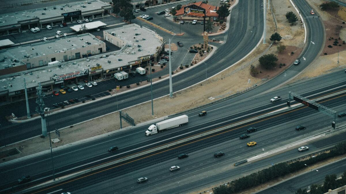
Highway 1 threads through California's Central Coast carrying tourists, agricultural haulers, and local commuters past the small city of Grover Beach. With roughly 13,500 residents in San Luis Obispo County, Grover Beach anchors the Five Cities area between Pismo Beach and Oceano. The Oceano Dunes State Vehicular Recreation Area draws off-road enthusiasts year-round, and Grand Avenue's commercial district generates pedestrian-vehicle conflicts that a small department must document thoroughly despite limited staffing.
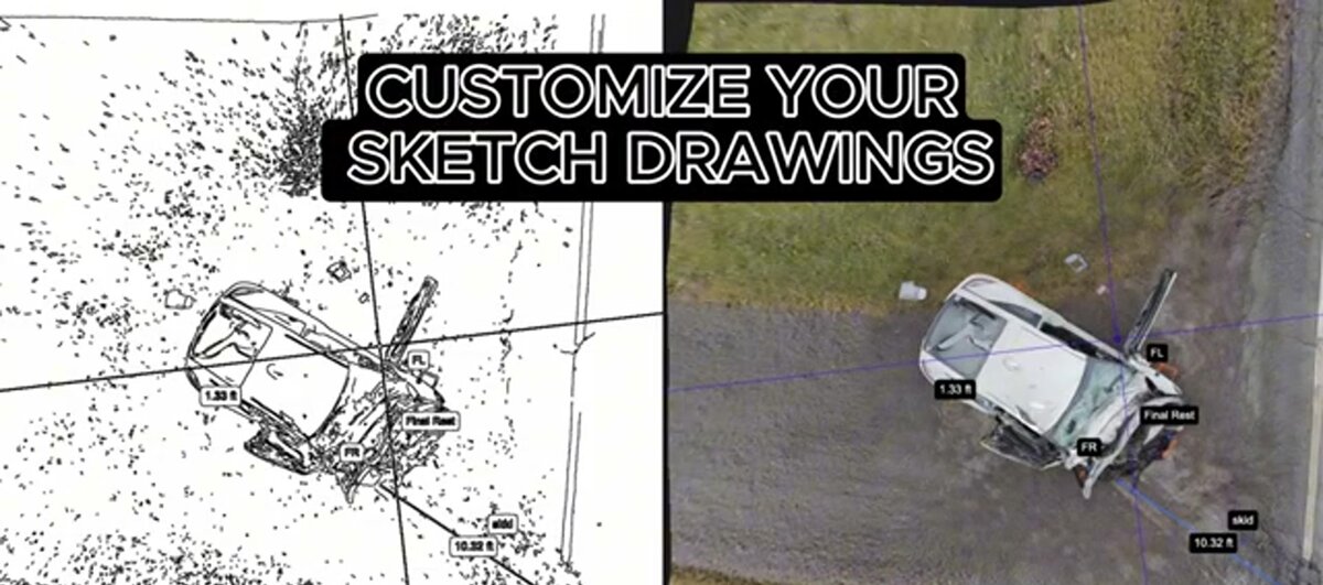
Grover Beach PD adopted SkyeBrowse — a videogrammetry platform that converts drone or smartphone video into court-ready 3D models — to give every patrol officer the ability to produce forensic-quality scene documentation without calling for a reconstruction team from outside the city.
Key Takeaways
- Before SkyeBrowse, a serious Highway 1 collision required Grover Beach PD to request reconstruction specialists from San Luis Obispo or Santa Maria — with wait times measured in hours while evidence sat exposed on the roadway.
- Central Coast morning fog compresses the window for capturing skid marks and debris; SkyeBrowse closes that documentation window in about 10 minutes, well before marine-layer moisture degrades the evidence.
- Scene clearance time on Highway 1 dropped significantly, reducing peak-season lane-closure minutes that otherwise back commuter traffic through Pismo Beach and into the agricultural corridor.
- Premium Advanced delivers measurement precision that Central Coast prosecutors can rely on without supplementary equipment, satisfying the standard San Luis Obispo County Superior Court applies to traffic fatality reconstructions.
- Any trained officer executes the capture, so documentation quality does not depend on whether the department's most experienced investigator happens to be on duty when a serious call comes in.
Contents
- Why Grover Beach Police Department Chose Videogrammetry
- Highway 1 and the Tourist Season Problem
- Accident and Crime Scene Documentation
- CJIS-Compliant 3D Evidence for California Courts
- Peak-Season Lane-Closure Minutes and Five Cities Traffic Flow
- FAQ
Why Grover Beach Police Department Chose Videogrammetry
Small departments face a staffing math problem. Pulling multiple officers to a multi-hour reconstruction can leave the rest of the city without adequate patrol coverage. Grover Beach PD operates with a lean roster, and mutual-aid requests for reconstruction specialists from San Luis Obispo or Santa Maria meant hours of wait time while evidence degraded. SkyeBrowse eliminates that dependency with a capture workflow that any trained officer can execute in about 10 minutes.
The mutual-aid dependency was the department's clearest pain point. Waiting hours for an outside reconstruction team to arrive means Highway 1 stays closed longer, evidence sits exposed to coastal weather, and patrol coverage thins as the on-scene crew grows. SkyeBrowse replaces that waiting with a capture any trained officer can execute immediately — drone footage or smartphone video uploaded directly to the cloud from the scene.
The video-to-3D pipeline is fast enough that the 3D model is typically ready for measurement before the officer has finished writing the incident narrative. That timeline matters on Highway 1, where extended closures back commuter traffic through Pismo Beach and into the agricultural corridor. Getting the road open faster is both a safety and a public-relations concern for the department.
The workflow is consistent enough for any trained officer to execute. A short capture checklist ensures repeatable results shift after shift, even when the department's most experienced investigators are off duty.
Highway 1 and the Tourist Season Problem
Highway 1 through the Five Cities area carries a collision mix that peaks during summer tourist season and Oceano Dunes weekends. Grover Beach PD needed a documentation solution that could absorb multiple simultaneous scenes without requiring specialist availability — a problem SkyeBrowse solves by distributing the capture capability across the entire patrol roster.
Oceano Dunes season reshapes Grover Beach's operational tempo. Weekend crowds double the population of the Five Cities corridor, Highway 1 backs up from Pismo Beach south through Oceano, and collision frequency climbs in the commercial district and on the Dunes approach roads. A department that needed specialist availability to document each scene was structurally unable to keep pace with peak-season demand.
SkyeBrowse distributes that capability across the entire roster. The first officer on any scene — whether a senior investigator or a first-year patrol officer — can begin documentation immediately. The department stops rationing scene documentation against specialist calendars. During high-volume summer weekends, that means each scene gets processed the same shift it occurs rather than queuing for the next available reconstruction-trained officer.
The seasonality creates a second pressure: Central Coast marine layer brings dense morning fog that reduces visibility and, after a collision, begins degrading tire marks and debris evidence. A documentation window that closes within minutes of the marine layer lifting cannot accommodate extended specialist wait times. A 10-minute capture workflow fits comfortably inside that window.
Accident and Crime Scene Documentation
Highway 1 through Grover Beach carries a volatile mix of high-speed through-traffic and local turns into shopping centers and residential streets. SkyeBrowse captures these scenes in about 10 minutes. The 3D model preserves the full roadway geometry, vehicle positions, skid marks, and traffic-control devices so analysts can reconstruct the event without a site return.
Left-turn collisions at the Grand Avenue intersection are common, and seasonal tourism spikes from the Oceano Dunes create congestion that amplifies rear-end chain reactions.
Foggy mornings along the Central Coast compress visibility and increase collision severity. Fast capture preserves tire marks and debris positions before marine-layer moisture washes them away. Officers no longer race the weather to finish manual measurements.
Crime scene documentation uses the same capture approach. Whether documenting a domestic-violence scene in a residential neighborhood or a theft scene along Grand Avenue, officers produce a spatial record that detectives and prosecutors access remotely through cloud-based sharing.

CJIS-Compliant 3D Evidence for California Courts
Cases from Grover Beach move through the San Luis Obispo County Superior Court, where prosecutors and defense attorneys expect precision and reproducibility. SkyeBrowse Premium Advanced delivers measurement precision that Central Coast prosecutors can rely on without supplementary equipment — meeting the bar for precise evidentiary documentation. The platform's security framework keeps evidence defensible from capture to verdict.
San Luis Obispo County Superior Court handles traffic fatality cases in which the precision of reconstruction measurements directly determines case outcomes. Defense experts in these proceedings challenge the methodology behind every measurement, and handcrafted scene diagrams rarely survive that scrutiny intact. SkyeBrowse gives Grover Beach prosecutors 3D models built from video data that can be independently verified — the underlying footage, the processing record, and the exported measurements are all part of the evidence package.
The platform stores all data on CJIS-compliant cloud infrastructure. That security architecture means the same controls used for federal law enforcement data protect the models Grover Beach officers upload from Highway 1 and Grand Avenue scenes. Every upload event is logged with a timestamp and user identity, creating the chain-of-custody record that SLO County prosecutors need when presenting 3D evidence to a jury. Long-term data retention ensures models remain accessible through the extended appellate timelines that serious California traffic cases can carry. A clean point cloud export integrates with the forensic CAD tools the county uses for trajectory and speed calculations.
Peak-Season Lane-Closure Minutes and Five Cities Traffic Flow
Every minute Highway 1 remains closed during peak tourist season ripples through the Five Cities area — backing up Pismo Beach's commercial district, delaying agricultural corridor haulers, and reducing Grover Beach PD's effective patrol coverage across a wider geography. SkyeBrowse's fast documentation cycle directly reduces the lane-closure window per incident, a measurable operational return for a department where every officer-minute is accounted for.
The staffing math at Grover Beach is unforgiving. When a major Highway 1 reconstruction holds a significant portion of the patrol roster on scene for an extended period, the rest of the Five Cities area — including the Dunes approach roads that generate their own pedestrian and vehicle conflicts — operates with whatever coverage remains. Recurring serious-collision calls represented a meaningful budget and coverage drain for a small-city department.
SkyeBrowse compresses that window to approximately 10 minutes of active capture. Officers clear the scene faster. The road reopens sooner. Supervisors stop burning through callback lists to backfill coverage during extended reconstruction holds. During peak Oceano Dunes season, when collision frequency along Highway 1 and in the Grand Avenue commercial district spikes, that efficiency margin becomes essential — the department can document multiple scenes per shift without the roster collapsing under simultaneous demands.
Peak-season lane-closure minutes saved is the clearest measure of SkyeBrowse's impact on Five Cities traffic flow. Each faster clearance is a shorter backup on a road that has no bypass when the primary lane closes. Training is also more equitable across the roster: a new officer follows the same capture checklist as a veteran and produces comparable results, reducing the department's historical dependency on reconstruction specialist availability.
FAQ
How does Grover Beach PD document Highway 1 collisions without a dedicated reconstruction team?
Any patrol officer on scene uploads footage from a department drone or smartphone to SkyeBrowse. The platform produces a measurable 3D model in about 10 minutes — fast enough to close the documentation before Central Coast morning fog burns off and washes away skid marks and debris evidence. The department no longer waits for reconstruction specialists from San Luis Obispo or Santa Maria. Learn more at skyebrowse.com.
Is SkyeBrowse evidence admissible in San Luis Obispo County Superior Court?
Yes. SkyeBrowse Premium Advanced delivers measurement precision that Central Coast prosecutors can rely on without supplementary equipment, and all data is stored on CJIS-compliant infrastructure. The immutable audit trail generated at upload documents chain of custody from field capture through presentation, meeting the evidentiary standards San Luis Obispo County Superior Court applies to traffic fatality and serious crime cases.
How does SkyeBrowse handle the Oceano Dunes tourism traffic surge that Grover Beach sees seasonally?
During peak Dunes season, Grover Beach PD sees elevated collision frequency on Highway 1 and in the Grand Avenue commercial district. SkyeBrowse's patrol-officer workflow means the department can document multiple scenes per shift without pulling the roster thin. Because any trained officer can execute the capture, the department is not dependent on a single specialist being available when calls stack up.
Get a SkyeBrowse Quote for Grover Beach Police Department
Grover Beach PD operates at the intersection of Central Coast tourism traffic, agricultural-corridor haulers, and seasonal Dunes visitors — all passing through a city with a roster that cannot sustain multi-hour, multi-officer reconstruction deployments. If the department is ready to move that documentation burden to a patrol-officer-executable workflow, contact SkyeBrowse to discuss how quickly the platform can be integrated into existing patrol operations.