Pike County, Kentucky, is the largest county in the Commonwealth by land area — 788 square miles of Appalachian ridgelines, narrow hollows, and winding two-lane roads that funnel roughly 58,000 residents' emergency calls into a single E-911 center in Pikeville. That center coordinates documentation requests across the county without the luxury of specialized reconstruction teams stationed in every hollow. When a coal truck overturns on a switchback grade 40 minutes from town, or flash flooding cuts off a community along Levisa Fork, the dispatch center needs a documentation solution that travels with whoever is already on scene — not one that requires summoning additional specialists from Pikeville. SkyeBrowse's videogrammetry platform gives Pike County E-911 exactly that: documentation detail that replaces the need for a specialized team to drive from the state capital, delivered by the officer or responder already present.

Key Takeaways
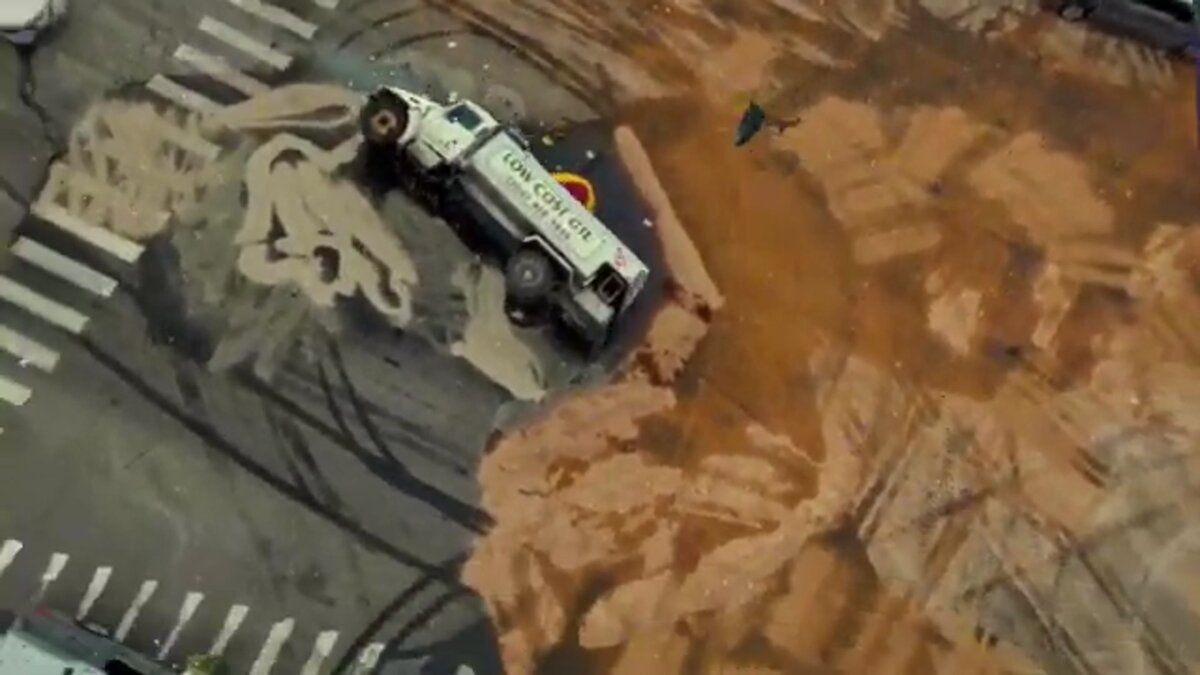
- Coal truck collisions on grades exceeding 10 percent — where debris fields scatter across road surface, embankment, and creek bed simultaneously — are fully documented in a single drone orbit, preserving elevation relationships that tape-and-sketch methods cannot capture.
- Pike County's position on the Kentucky-Virginia-West Virginia tri-state border means incidents on US-23 routinely require coordination with Kentucky State Police, Virginia State Police, and municipal departments across two state jurisdictions — SkyeBrowse's cloud sharing puts every agency on the same 3D record without anyone driving hours to a shared conference room.
- Flash flooding along Levisa Fork isolates communities faster than ground crews can reach them; aerial 3D capture documents flood extent and damage across otherwise inaccessible hollows for FEMA damage assessment workflows.
- SkyeBrowse provides documentation detail that replaces the need for a specialized team to drive from the state capital — any trained responder already on scene produces a court-ready model for the 35th Judicial Circuit.
- Because neighboring Floyd, Letcher, and Martin counties use the same SkyeBrowse workflow, models are compatible for joint review during multi-county investigations without any file conversion.
Contents
- Why Pike County E-911 Chose Videogrammetry
- County-Wide Documentation Reach from a Single Dispatch Center
- Cross-Agency Coordination and Rural Coverage
- Digital Evidence Standards for Kentucky's Rural Jurisdictions
- Documentation Requests Fulfilled Without Deploying Specialists from Pikeville
- FAQ
Why Pike County E-911 Chose Videogrammetry
Pike County's topography creates documentation challenges that flat-terrain agencies never encounter. Crash scenes on mountain roads often sit on grades exceeding 10 percent, with guardrails, rock cuts, and creek beds complicating measurement geometry. SkyeBrowse eliminates that geometric complexity by generating a measurable 3D model from a single drone orbit, preserving elevation data, slope angles, and spatial relationships between all evidence without requiring a total-station setup on a banked curve — and without requiring a specialist to travel from Pikeville.
The county's coal heritage means heavy truck traffic persists on narrow roads originally designed for much lighter loads. Collisions between loaded coal trucks and passenger vehicles produce complex debris fields that extend across multiple elevation changes. Traditional tape-and-photo methods struggle to capture vertical displacement between road surface, embankment, and creek bed — and traditional methods require personnel time that a county of 788 square miles cannot afford to concentrate at a single scene.
A responder launches a drone, flies a single orbit over the scene, and submits the footage from the field. The platform processes the video in real time — one minute of captured footage yields a finished model in roughly one minute — so by the time the responder is back in the vehicle, the 3D record is already building in the cloud. Pike County did not need to invest in specialized survey equipment. Responders use hardware they already carry.
County-Wide Documentation Reach from a Single Dispatch Center
Pike County's call volume spans accident reconstruction, criminal investigation, search and rescue in mountainous terrain, and flood damage assessment. SkyeBrowse serves all of those missions with a single capture workflow. The E-911 center in Pikeville fulfills documentation requests across the entire 788-square-mile county by dispatching the officer already on scene — no specialist convoy required, average response-to-documentation time determined by the responder on the ground rather than travel time from headquarters.
Accident reconstruction on US-23 and US-119 is the highest-volume use case. These corridors connect eastern Kentucky to Virginia and West Virginia, carrying commercial and passenger traffic through narrow mountain cuts. The NHTSA Traffic Safety Facts database consistently shows rural road fatality rates significantly higher than urban, underscoring the need for thorough and efficient documentation at scenes that may take 40 minutes or more for a second unit to reach.
Search and rescue operations in the county's hollows and ridgelines benefit from aerial 3D mapping. A drone capture of a search area provides ground teams with a spatial reference that accounts for canopy cover, terrain breaks, and access trails. The resulting model documents the search effort for after-action review and liability protection.
Flood response is a recurring need. Pike County's narrow valleys channel water from mountain tributaries into communities along Levisa Fork and its branches. TacBrowse supports tactical operations for high-risk warrant service in remote properties where aerial reconnaissance provides the only safe approach to pre-planning entry routes and perimeter positions.

Cross-Agency Coordination and Rural Coverage
Pike County borders Virginia and West Virginia, and incidents on US-23 near the state line involve multi-state coordination. SkyeBrowse's cloud-based sharing lets Pike County E-911, Kentucky State Police, Virginia State Police, and local municipal departments review the same 3D model without driving hours to a shared conference room. A standardized documentation platform means models captured by any participating agency meet the same forensic standards, simplifying evidence exchange and joint investigations.
Pikeville Medical Center, the region's Level II trauma center, serves a catchment area that extends well beyond county lines. Crash documentation that feeds quickly into the medical-legal pipeline helps trauma teams and prosecutors work from consistent evidence, reducing the delay between scene capture and case file completion.
Mutual aid with neighboring Floyd, Letcher, and Martin counties is routine. Because every participating agency uses the same SkyeBrowse workflow, models are compatible for collaborative review during joint investigations — the E-911 center in Pikeville can route documentation from any county boundary incident into a unified case file without format conversions or platform mismatches.
Digital Evidence Standards for Kentucky's Rural Jurisdictions
Evidence in Kentucky Circuit Courts must meet standards for accuracy, chain of custody, and scientific reliability. Pike County cases move through the 35th Judicial Circuit, where prosecutors and defense experts challenge measurement methodology. SkyeBrowse's CJIS-compliant workflows with audit trails provide the chain-of-custody documentation these proceedings require — and meet Kentucky's digital evidence standards for rural jurisdictions where the capturing officer may be the only witness to the scene's initial state.
For Pike County investigators working crash reconstruction on US-23 or criminal scene documentation in remote hollows, the chain-of-custody challenge is compounded by geography. Evidence is often captured miles from any courthouse, by a single responder, under time pressure from weather or traffic. CJIS-compliant audit trails record every access event on a model — capture timestamp, processing log, and every download or share — so investigators can testify to data integrity without relying on memory or field notes alone.
The 35th Judicial Circuit handles cases where defense experts regularly retain their own accident reconstructionists to challenge state measurements. SkyeBrowse's documented accuracy tiers give Commonwealth attorneys documentation detail that replaces the need for a specialized team to drive from the state capital — any trained responder in the field produces the same technically defensible foundation that survives cross-examination. Long-term data retention ensures case files remain accessible through appeals without risk of routine archival purges deleting key evidence.
Documentation Requests Fulfilled Without Deploying Specialists from Pikeville
In a county covering 788 square miles of mountain terrain, deploying a specialist from Pikeville to every documentation scene is not operationally viable. SkyeBrowse shifts the documentation capability to whoever is already on scene, so the E-911 center fulfills documentation requests across the entire county with the resources already dispatched — without pulling additional personnel off coverage to travel to a remote location.
Consider a coal truck collision on a KY-80 switchback 40 minutes from the nearest backup unit. Under traditional methods, thorough documentation required either waiting for a specialist to arrive or holding the responding officer on scene for an extended measurement session while coverage gaps opened across the rest of the county. With a drone capture completed in about 10 minutes, the officer completes documentation and is available for the next call before the wrecker has finished clearing the debris field — and no specialist ever had to leave Pikeville.
The savings extend beyond individual scenes. Eliminating the need to dispatch a second or third unit for measurement work reduces overtime exposure on complex scenes. Across dozens of annual incidents — reconstructions, flood assessments, search operations — the cumulative difference in personnel cost and coverage hours is substantial. The trained-responder model also removes the dependency on a specialist who may be hours away from a remote mountain hollow; any responder on scene produces the same court-ready output, and the E-911 center's average response-to-documentation time across the county's geography is determined by dispatch time, not specialist travel time.

FAQ
How does SkyeBrowse handle crash documentation on steep mountain roads?
SkyeBrowse eliminates the geometric complexity of mountain terrain by capturing the full scene from a drone orbit. The platform generates a measurable 3D model that preserves elevation data, slope angles, and spatial relationships between all evidence, including vertical displacement between road surface, embankment, and creek bed. Learn more about supported workflows at skyebrowse.com/tutorials.
Can SkyeBrowse support multi-state incident coordination for agencies near state lines?
Yes. SkyeBrowse's cloud-based sharing lets agencies in different states review the same 3D model without traveling to a shared conference room. For incidents on US-23 near Kentucky's border with Virginia and West Virginia, Pike County E-911, Kentucky State Police, and Virginia State Police can all access the same scene data from a single secure link.
How does Pike County E-911 use GeoTIFF outputs for flood damage documentation?
After flash floods along Levisa Fork and its tributaries, drone footage captured over affected communities is processed into GeoTIFF orthomosaics that layer directly into Pike County's emergency management GIS platform. The orthos provide a georeferenced aerial record of flood extent and structural damage that FEMA damage assessors use to verify and prioritize assistance applications — without requiring ground teams to physically access every isolated property. See skyebrowse.com/pricing-premium for tier details.