# DJI Mini 3 Pro Mapping: Specs, GSD, Flight App Setup and the 3D Workflow
> DJI Mini 3 Pro mapping guide: Orbit and WideBrowse with the DJI RC Pro, GSD by altitude, how the Mini 3 differs, and turning video into a 3D model.
Source: https://www.skyebrowse.com/news/posts/dji-mini-3-pro-mapping
Published: 2026-10-14
DJI Mini 3 Pro mapping gives small crews a sub-250 g aircraft that flies automated 3D capture missions, because the Mini 3 Pro paired with the DJI RC Pro is on the SkyeBrowse Flight App fully supported list. Videogrammetry, the technique of building a 3D model from continuous video frames, lets the drone record one clip instead of hundreds of overlapping stills. This guide covers the mapping specs, the controller rules, GSD by altitude, mission settings, how the standard Mini 3 differs, and what a model costs.
## Key Takeaways
- The Mini 3 Pro flies automated Orbit and WideBrowse missions in the SkyeBrowse Flight App only when paired with the DJI RC Pro; any other controller means manual flight plus Universal Upload.
- DJI lists a 1/1.3-inch 48MP sensor, a 24 mm equivalent f/1.7 lens and 4K video up to 60 fps at 150 Mbps, a strong mapping camera for its weight class.
- In 4K, each pixel covers about 1.2 cm of ground at 30 m and 2.3 cm at 60 m, and the frame spans roughly 1.5 times the flight height.
- The standard DJI Mini 3 is semi supported: with the RC Pro it flies automated Orbits but no WideBrowse grids, so larger areas go through Universal Upload.
- Fly low and close for detail: Commercial and Pro models measure to 0.5 inch, and Public Safety & Enterprise models reach 0.1 inch.
## Contents
- [What is the DJI Mini 3 Pro, and is it good for mapping?](#what-is-the-dji-mini-3-pro-and-is-it-good-for-mapping)
- [Does SkyeBrowse support the DJI Mini 3 Pro?](#does-skyebrowse-support-the-dji-mini-3-pro)
- [What GSD does the Mini 3 Pro deliver at common altitudes?](#what-gsd-does-the-mini-3-pro-deliver-at-common-altitudes)
- [What settings give the best Mini 3 Pro 3D models?](#what-settings-give-the-best-mini-3-pro-3d-models)
- [How does the DJI Mini 3 differ from the Mini 3 Pro for mapping?](#how-does-the-dji-mini-3-differ-from-the-mini-3-pro-for-mapping)
- [What jobs suit a Mini 3 Pro 3D model?](#what-jobs-suit-a-mini-3-pro-3d-model)
- [What does it cost to turn Mini 3 Pro video into a 3D model?](#what-does-it-cost-to-turn-mini-3-pro-video-into-a-3d-model)
- [FAQ](#faq)
## What is the DJI Mini 3 Pro, and is it good for mapping?
The DJI Mini 3 Pro is a folding camera drone that weighs under 249 g and carries a 1/1.3-inch 48MP sensor behind a 24 mm equivalent f/1.7 lens. It's good for small-site mapping: it records 4K video up to 60 fps, senses obstacles forward, backward and downward, and flies about half an hour per battery.
The figures below come from DJI's [Mini 3 Pro support and specifications page](https://www.dji.com/support/product/mini-3-pro).
| Spec | DJI Mini 3 Pro |
| --- | --- |
| Takeoff weight | Under 249 g with the standard battery |
| Image sensor | 1/1.3-inch CMOS, 48MP effective |
| Lens | 82.1° FOV, 24 mm equivalent, f/1.7 |
| Video | 4K at up to 60 fps, 150 Mbps max bitrate |
| Max flight time | 34 minutes (47 minutes with Intelligent Flight Battery Plus) |
| Wind resistance | 10.7 m/s (Level 5) |
| Obstacle sensing | Forward, backward and downward vision |
| Max transmission (FCC) | 12 km |
| Telemetry | Separate .SRT subtitle file per video |
That last row matters for mapping. DJI's FAQ confirms the Mini 3 Pro writes a separate .SRT subtitle file beside each clip, and that file carries the GPS track that georeferences the finished model.
## Does SkyeBrowse support the DJI Mini 3 Pro?
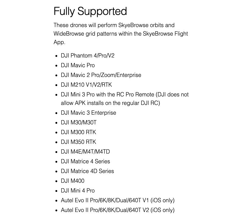
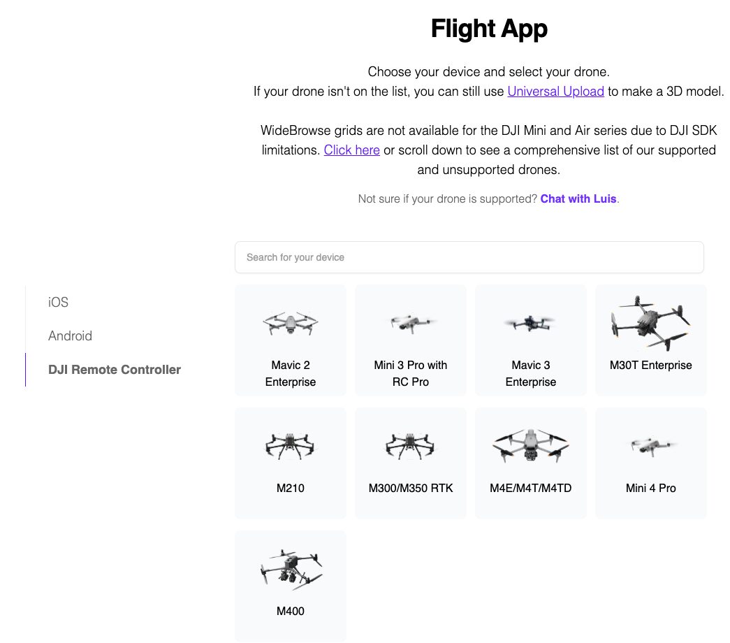
Yes, with one controller rule. The Mini 3 Pro with the DJI RC Pro is fully supported in the SkyeBrowse Flight App, so it flies automated Orbit and WideBrowse missions. DJI doesn't allow app installs on the standard DJI RC, so pilots on that controller or the RC-N1 fly manually and use Universal Upload.
Sideload the Android build of the Flight App onto the RC Pro from the [SkyeBrowse download page](https://www.skyebrowse.com/download), then confirm the pairing on the [supported drones page](https://www.skyebrowse.com/supported-drones). Our [Flight App tutorial](/news/posts/tutorial-skye-browse-flight-app) walks through a first mission.
Orbit flies two automated circles around a scene smaller than an acre, such as a house, a crash or a storefront. WideBrowse grids larger ground, with Cross Grids for structured scenes, Side Scan for facades, and Previous Flights to reload a site you revisit.
Without the RC Pro, the drone still makes good models. Fly in DJI Fly with Video Subtitles switched on, then upload the .MP4 and its .SRT through [Universal Upload](/news/posts/tutorial-universal-upload). Both paths finish in the same browser-based [drone mapping software](/news/posts/free-drone-mapping-software).
## What GSD does the Mini 3 Pro deliver at common altitudes?
Ground sample distance, or GSD, is the width of ground one pixel represents. Recording 4K on the Mini 3 Pro gives about 1.2 cm per pixel at 30 m, 2.3 cm at 60 m and 4.7 cm at 120 m. Each frame spans about 1.5 times the flight height on the ground.
GSD equals sensor width times altitude, divided by focal length times image width in pixels. Using DJI's 24 mm equivalent focal length, a 36 mm equivalent sensor width and 3,840-pixel 4K frames gives the values below. Our [ground sample distance guide](/news/posts/ground-sample-distance) explains the math in more depth.
| Altitude above ground | GSD, 4K video | Frame width on ground |
| --- | --- | --- |
| 20 m (66 ft) | 0.8 cm/pixel | 30 m |
| 30 m (98 ft) | 1.2 cm/pixel | 45 m |
| 40 m (131 ft) | 1.6 cm/pixel | 60 m |
| 60 m (197 ft) | 2.3 cm/pixel | 90 m |
| 120 m (394 ft) | 4.7 cm/pixel | 180 m |
The 120 m row sits just under the 400 ft ceiling the [FAA sets for Part 107 flights](https://www.faa.gov/uas/commercial_operators). Detail scales with capture distance, so a low pass at 20 to 30 m resolves the shingle lines and curb edges a higher flight blurs together.
## What settings give the best Mini 3 Pro 3D models?
Record 4K at 30 fps or higher, lock the zoom at 1x, and set exposure and white balance manually before launch. Use Orbit for a single structure or a scene under an acre and WideBrowse for larger ground. Keep ground speed modest and switch on Video Subtitles so every clip writes its .SRT file.
The Mini 3 Pro's digital zoom crops the sensor, which changes the effective lens between frames, so leave it at 1x for every mapping clip. A 1080p clip still processes, faster and at lower resolution; 4K gives the model more detail to work with.
Manual exposure keeps the texture even as the aircraft turns toward and away from the sun, and a fixed white balance stops color from shifting between the north and south sides of a building.
For hand-flown grids, plan about 70 to 80 percent overlap between lines, move around the subject instead of panning in place, and keep sky, glass and water out of frame. A small aircraft feels gusts more than a heavy one, so fly calm mornings when the forecast is near the 10.7 m/s limit.
## How does the DJI Mini 3 differ from the Mini 3 Pro for mapping?
The standard DJI Mini 3 shares the 1/1.3-inch 48MP sensor and 24 mm f/1.7 lens but records 4K only up to 30 fps at 100 Mbps and senses obstacles downward only. In SkyeBrowse, the Mini 3 with the RC Pro is semi supported: automated Orbits work, WideBrowse grids don't.
DJI's [Mini 3 specifications](https://www.dji.com/mini-3/specs) list 38 minutes of flight on the standard battery, a few minutes longer than the Mini 3 Pro. That extra time helps on manual grids, which is how Mini 3 pilots cover anything bigger than an Orbit.
| Feature | DJI Mini 3 Pro | DJI Mini 3 |
| --- | --- | --- |
| Sensor and lens | 1/1.3-inch 48MP, 24 mm f/1.7 | 1/1.3-inch 48MP, 24 mm f/1.7 |
| Max 4K frame rate | 60 fps | 30 fps |
| Max bitrate | 150 Mbps | 100 Mbps |
| Obstacle sensing | Forward, backward, downward | Downward |
| Max flight time | 34 min | 38 min |
| SkyeBrowse Flight App with RC Pro | Orbit and WideBrowse | Orbit only |
| Without RC Pro | Universal Upload | Universal Upload |
If you're shopping for a new aircraft rather than mapping with one you own, the newer [DJI Mini 4 Pro mapping guide](/news/posts/dji-mini-4-pro-mapping) and [Mini 5 Pro mapping guide](/news/posts/dji-mini-5-pro-mapping) cover the current generation, and our [mini drone surveying](/news/posts/mini-drone-surveying) guide compares the sub-250 g class.
## What jobs suit a Mini 3 Pro 3D model?
The Mini 3 Pro suits jobs where a small, quiet aircraft and fast setup matter more than payload options: residential roofs, insurance property documentation, small crash and incident scenes, real estate sites and construction progress on a single lot. Larger corridors and heavy wind call for an enterprise aircraft.
**Roofs and property claims.** An Orbit around a house gives a measurable model of slopes, ridges and damage areas without a ladder. Our [drone roof inspection](/news/posts/drone-roof-inspection) and [insurance claims documentation](/news/posts/insurance-claims-documentation) guides cover the deliverables.
**Small incident scenes.** A two-orbit capture records vehicle rest positions and debris before a road reopens. The [accident reconstruction drone mapping](/news/posts/accident-reconstruction-drone-mapping) guide shows the workflow end to end.
**Real estate and site progress.** A WideBrowse grid over a lot produces an orthomosaic, a scale-correct top-down map, that you can share by link. See our [real estate marketing](/news/posts/real-estate-marketing) guide for ideas.
On weight, the FAA lets drones of 250 g or less skip registration only when flown under the recreational exception; [all drones flown under Part 107 must be registered](https://www.faa.gov/uas/getting_started/register_drone) and comply with Remote ID. Paid mapping work is Part 107 work.
## What does it cost to turn Mini 3 Pro video into a 3D model?
Uploading Mini 3 Pro video and building models on Freemium costs nothing. For full resolution you pay per model: $24.99 for a Commercial model stored 3 months, $49.99 for a Pro model stored a year with exports, or $199 per model per year on Public Safety & Enterprise.
Commercial and Pro reconstruct at 8K with 0.5 inch accuracy, and annual billing drops them to $19.99 and $39.99. Only Pro adds LAZ point cloud, GLB mesh and GeoTIFF orthomosaic exports. Public Safety & Enterprise adds 16K Ultra processing at 0.1 inch, CJIS compliance, chain of custody and unlimited users. Freemium organizations that have never had a paid plan can get a first Commercial model for $5. Compare options on the [pricing page](https://www.skyebrowse.com/pricing) or in our [drone mapping app](/news/posts/drone-mapping-app) roundup.
## FAQ
**Can the DJI Mini 3 Pro do mapping?**
Yes. The Mini 3 Pro records 4K video on a 1/1.3-inch sensor, and with the DJI RC Pro it runs the SkyeBrowse Flight App's automated Orbit and WideBrowse missions. The video becomes a measurable 3D model and an orthomosaic in the browser. Check your pairing on the [supported drones list](https://www.skyebrowse.com/supported-drones).
**Does the Mini 3 Pro need the DJI RC Pro for SkyeBrowse?**
For automated Flight App missions, yes. DJI does not allow app installs on the standard DJI RC, so pilots using the DJI RC or RC-N1 fly manually in DJI Fly and send the clip and its .SRT file through Universal Upload instead.
**What altitude should I fly a Mini 3 Pro for a 3D model?**
Pick altitude from the detail you need. In 4K, the Mini 3 Pro covers about 1.2 cm per pixel at 30 m and 2.3 cm at 60 m. Lower flights give finer measurements, and every flight stays under the FAA's 400 ft ceiling.